Mount Tyrwhitt
Mount Tyrwhitt is a mountain in British Columbia and Alberta, Canada located between Highway 40 and Elk Pass in the Elk Range of the Canadian Rockies, west of the Highwood Pass parking lot in Kananaskis Country and south east of Upper Kananaskis Lake. Located on the Continental Divide, it is also therefore on the border between British Columbia and Alberta which follows the Divide in this area.
| Mount Tyrwhitt | |
|---|---|
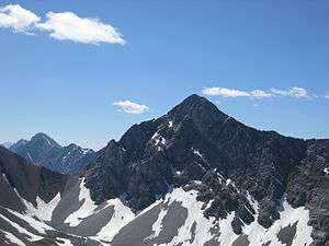 Mount Tyrwhitt's north face with Grizzly col to the left | |
| Highest point | |
| Elevation | 2,874 m (9,429 ft) [1] |
| Prominence | 216 m (709 ft) [2] |
| Coordinates | 50°34′57″N 115°00′58″W [3] |
| Geography | |
 Mount Tyrwhitt Location in eastern British Columbia | |
| Location | Alberta/British Columbia, Canada |
| Parent range | Elk Range |
| Topo map | NTS 82J/10 |
| Climbing | |
| First ascent | 1915 by the Interprovincial Boundary Commission[2] |
| Easiest route | Scramble (Moderate) |
The mountain was named in 1918 after First Admiral Reginald Tyrwhitt, a senior officer in the Royal Navy during the First World War.[3]
Gallery
 Mount Tyrwhitt from Kananaskis Trail
See also
- Mountains of Alberta
- Mountains of British Columbia
- List of peaks on the British Columbia-Alberta border
References
- "Mount Tyrwhitt". PeakFinder.com. Retrieved 2019-08-20.
- "Mount Tyrwhitt". Bivouac.com. Retrieved 2009-01-02.
- "Mount Tyrwhitt". BC Geographical Names. Retrieved 2013-06-12.
External links
This article is issued from Wikipedia. The text is licensed under Creative Commons - Attribution - Sharealike. Additional terms may apply for the media files.