Mount Richards
Mount Richards is a 2,377-metre (7,799-foot) summit located in Waterton Lakes National Park, in the Canadian Rockies of Alberta, Canada. It is situated just north of the Canada–United States border, with the south footing of the mountain at Boundary Creek just within Glacier National Park of the United States. Its nearest higher peak is Mount Alderson, 2.0 km (1.2 mi) to the northwest.[1] Bertha Lake and Bertha Peak are situated immediately to the north.
| Mount Richards | |
|---|---|
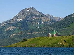 The northern end of Mount Richards seen with Prince of Wales Hotel | |
| Highest point | |
| Elevation | 2,377 m (7,799 ft) [1] |
| Prominence | 137 m (449 ft) [1] |
| Parent peak | Mount Alderson (2692 m) |
| Listing | Mountains of Alberta |
| Coordinates | 49°00′37″N 113°56′30″W [2] |
| Geography | |
 Mount Richards Location of Mount Richards in Alberta  Mount Richards Mount Richards (Canada) | |
| Location | Alberta, Canada |
| Parent range | Clark Range[3] Canadian Rockies |
| Topo map | NTS 82H04[2] |
| Geology | |
| Age of rock | Cambrian |
| Climbing | |
| Easiest route | Scrambling[4] |

History
Mount Richards was named in honor of Admiral Sir George Henry Richards (1820–1896), Hydrographer of the Navy who was the Second Commissioner of the British Boundary Commission which delineated the border from the Pacific to the Rockies.[5] It has also been called Sleeping Indian Mountain.[6] The mountain's name became official in 1943 by the Geographical Names Board of Canada.[2]
Geology
Like other mountains in Waterton Lakes National Park, Mount Richards is composed of sedimentary rock laid down during the Precambrian to Jurassic periods. Formed in shallow seas, this sedimentary rock was pushed east and over the top of younger Cretaceous period rock during the Laramide orogeny.[7]
Climate
Based on the Köppen climate classification, Mount Richards is located in a subarctic climate with cold, snowy winters, and mild summers.[8] Temperatures can drop below −20 °C with wind chill factors below −30 °C. Precipitation runoff from Mount Richards drains into Waterton Lake, thence Waterton River.
References
- "Mount Richards". Bivouac.com. Retrieved 2018-11-18.
- "Mount Richards". Geographical Names Data Base. Natural Resources Canada. Retrieved 2018-11-19.
- "Clark Range". Peakbagger.com. Retrieved 2020-06-25.
- Richards, Mount (Sleeping Indian)Explor8ion
- RichardsPlace-names of Alberta
- "Mount Richards". SummitPost.org. Retrieved 2020-06-25.
- Gadd, Ben (2008), Geology of the Rocky Mountains and Columbias
- Peel, M. C.; Finlayson, B. L. & McMahon, T. A. (2007). "Updated world map of the Köppen−Geiger climate classification". Hydrol. Earth Syst. Sci. 11: 1633–1644. ISSN 1027-5606.
See also
External links
- Mount Richards weather forecast
- Parks Canada web site: Waterton Lakes National Park