National Register of Historic Places listings in Morgan County, West Virginia
This is a list of the National Register of Historic Places listings in Morgan County, West Virginia.
This is intended to be a complete list of the properties and districts on the National Register of Historic Places in Morgan County, West Virginia, United States. The locations of National Register properties and districts for which the latitude and longitude coordinates are included below, may be seen in an online map.[1]
There are 14 properties and districts listed on the National Register in the county.
- This National Park Service list is complete through NPS recent listings posted June 26, 2020.[2]
Barbour - Berkeley - Boone - Braxton - Brooke - Cabell - Calhoun - Clay - Doddridge - Fayette - Gilmer - Grant - Greenbrier - Hampshire - Hancock - Hardy - Harrison - Jackson - Jefferson - Kanawha - Lewis - Lincoln - Logan - Marion - Marshall - Mason - McDowell - Mercer - Mineral - Mingo - Monongalia - Monroe - Morgan - Nicholas - Ohio - Pendleton - Pleasants - Pocahontas - Preston - Putnam - Raleigh - Randolph - Ritchie - Roane - Summers - Taylor - Tucker - Tyler - Upshur - Wayne - Webster - Wetzel - Wirt - Wood - Wyoming |
Current listings
| [3] | Name on the Register[4] | Image | Date listed[5] | Location | City or town | Description |
|---|---|---|---|---|---|---|
| 1 | Ambrose Chapel | December 15, 1998 (#98001470) |
Winchester Grade Rd. 39°31′42″N 78°13′53″W |
Stotlers Crossroads | ||
| 2 | Berkeley Springs State Park | 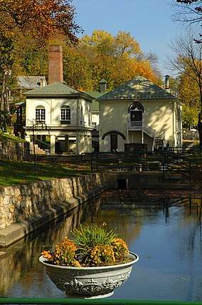 Berkeley Springs State Park |
May 24, 1976 (#76001943) |
S. Washington and Fairfax Sts. 39°37′35″N 78°13′44″W |
Berkeley Springs | |
| 3 | Berkeley Springs Train Depot | 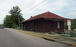 Berkeley Springs Train Depot |
March 23, 2001 (#00001313) |
504 N. Washington St. 39°37′52″N 78°13′28″W |
Berkeley Springs | |
| 4 | Chesapeake and Ohio Canal National Historical Park | 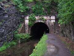 Chesapeake and Ohio Canal National Historical Park |
October 15, 1966 (#66000036) |
Bordering the Potomac River from Georgetown, D.C. to Cumberland, Maryland 38°53′59″N 77°03′28″W |
Harpers Ferry, Paw Paw, and Shepardstown | |
| 5 | T. H. B. Dawson House | 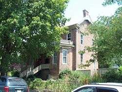 T. H. B. Dawson House |
February 10, 1983 (#83003247) |
300 S. Green St. 39°37′27″N 78°13′39″W |
Berkeley Springs | |
| 6 | Clarence Hovermale House | 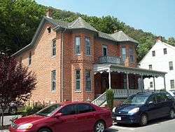 Clarence Hovermale House |
May 2, 2003 (#03000350) |
167 Wilkes St. 39°37′42″N 78°13′41″W |
Berkeley Springs | |
| 7 | Morgan County Courthouse | 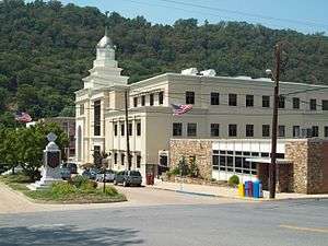 Morgan County Courthouse |
September 7, 2005 (#05001004) |
202 Fairfax St. 39°37′44″N 78°13′39″W |
Berkeley Springs | |
| 8 | New Deal Resources in Cacapon State Park Historic District | 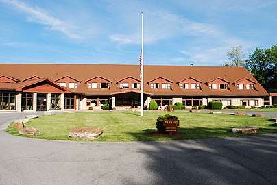 New Deal Resources in Cacapon State Park Historic District |
August 12, 2019 (#100002853) |
818 Cacapon Lodge Drive 39°30′21″N 78°18′07″W |
Berkeley Springs | |
| 9 | John Herbert Quick House | 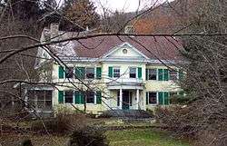 John Herbert Quick House |
August 23, 1984 (#84003639) |
Off U.S. Route 522 39°34′56″N 78°16′03″W |
Berkeley Springs | |
| 10 | Sloat-Horn-Rossell House | 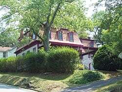 Sloat-Horn-Rossell House |
August 23, 1984 (#84003643) |
415 Fairfax St. 39°37′37″N 78°13′34″W |
Berkeley Springs | |
| 11 | Samuel Taylor Suit Cottage | 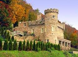 Samuel Taylor Suit Cottage |
November 28, 1980 (#80004035) |
WV 9 39°37′38″N 78°13′49″W |
Berkeley Springs | |
| 12 | Town of Bath Historic District | 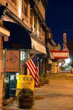 Town of Bath Historic District |
April 23, 2009 (#09000245) |
Roughly Washington and Fairfax Sts. and adjacent blocks 39°37′36″N 78°13′40″W |
Berkeley Springs | |
| 13 | Western Maryland Railroad Right-of-Way, Milepost 126 to Milepost 160 | 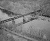 Western Maryland Railroad Right-of-Way, Milepost 126 to Milepost 160 |
July 23, 1981 (#81000078) |
Milepost 126 to Milepost 160 39°33′53″N 78°32′08″W |
Jerome | |
| 14 | Judge John W. Wright Cottage | 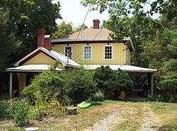 Judge John W. Wright Cottage |
April 28, 1986 (#86000896) |
305 S. Green St. 39°37′28″N 78°13′40″W |
Berkeley Springs |
See also
| Wikimedia Commons has media related to National Register of Historic Places in Morgan County, West Virginia. |
References
- The latitude and longitude information provided in this table was derived originally from the National Register Information System, which has been found to be fairly accurate for about 99% of listings. Some locations in this table may have been corrected to current GPS standards.
- "National Register of Historic Places: Weekly List Actions". National Park Service, United States Department of the Interior. Retrieved on June 26, 2020.
- Numbers represent an ordering by significant words. Various colorings, defined here, differentiate National Historic Landmarks and historic districts from other NRHP buildings, structures, sites or objects.
- "National Register Information System". National Register of Historic Places. National Park Service. April 24, 2008.
- The eight-digit number below each date is the number assigned to each location in the National Register Information System database, which can be viewed by clicking the number.
| Topics | ||
|---|---|---|
| Lists by county |
| |
| Other lists | ||
| ||
Municipalities and communities of Morgan County, West Virginia, United States | ||
|---|---|---|
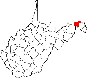
| Towns | Map of West Virginia highlighting Morgan County | |
| CDP | ||
| Unincorporated communities |
| |