Montpeyroux, Aveyron
Montpeyroux (in Occitan: Mont Peirós)is a commune in the Aveyron department in southern France. Residents of the commune are referred to as Montpeirosiens.
Montpeyroux | |
|---|---|
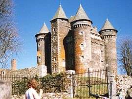 The Château of Bousquet | |
Location of Montpeyroux 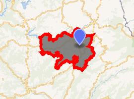
| |
 Montpeyroux  Montpeyroux | |
| Coordinates: 44°38′33″N 2°49′32″E | |
| Country | France |
| Region | Occitanie |
| Department | Aveyron |
| Arrondissement | Rodez |
| Canton | Aubrac et Carladez |
| Government | |
| • Mayor (2008–2014) | Gilbert Cestrieres |
| Area 1 | 61.71 km2 (23.83 sq mi) |
| Population (2017-01-01)[1] | 541 |
| • Density | 8.8/km2 (23/sq mi) |
| Time zone | UTC+01:00 (CET) |
| • Summer (DST) | UTC+02:00 (CEST) |
| INSEE/Postal code | 12156 /12210 |
| Elevation | 510–1,023 m (1,673–3,356 ft) (avg. 967 m or 3,173 ft) |
| 1 French Land Register data, which excludes lakes, ponds, glaciers > 1 km2 (0.386 sq mi or 247 acres) and river estuaries. | |
In 1790–1794, the commune absorbed Seignour Delcros, Engalenc and Esparou; in 1832, it absorbed Le Bousquet, Brionnès and Crozillac.
Population
| Historical population | ||
|---|---|---|
| Year | Pop. | ±% |
| 1793 | 1,731 | — |
| 1800 | 1,705 | −1.5% |
| 1806 | 1,970 | +15.5% |
| 1821 | 2,037 | +3.4% |
| 1831 | 2,032 | −0.2% |
| 1836 | 2,098 | +3.2% |
| 1841 | 1,943 | −7.4% |
| 1846 | 1,900 | −2.2% |
| 1851 | 1,834 | −3.5% |
| 1856 | 1,774 | −3.3% |
| 1861 | 1,772 | −0.1% |
| 1866 | 1,680 | −5.2% |
| 1872 | 1,785 | +6.2% |
| 1876 | 1,716 | −3.9% |
| 1881 | 1,731 | +0.9% |
| 1886 | 1,649 | −4.7% |
| 1891 | 1,466 | −11.1% |
| 1896 | 1,526 | +4.1% |
| 1901 | 1,405 | −7.9% |
| 1906 | 1,382 | −1.6% |
| 1911 | 1,257 | −9.0% |
| 1921 | 1,135 | −9.7% |
| 1926 | 1,100 | −3.1% |
| 1931 | 1,062 | −3.5% |
| 1936 | 1,035 | −2.5% |
| 1946 | 1,031 | −0.4% |
| 1954 | 925 | −10.3% |
| 1962 | 806 | −12.9% |
| 1968 | 787 | −2.4% |
| 1975 | 670 | −14.9% |
| 1982 | 610 | −9.0% |
| 1990 | 578 | −5.2% |
| 1999 | 551 | −4.7% |
| 2008 | 568 | +3.1% |
See also
References
- "Populations légales 2017". INSEE. Retrieved 6 January 2020.
| Wikimedia Commons has media related to Montpeyroux (Aveyron). |
| Authority control |
|
|---|
This article is issued from Wikipedia. The text is licensed under Creative Commons - Attribution - Sharealike. Additional terms may apply for the media files.