Asprières
Asprières is a commune in the Aveyron department in the Occitanie region of southern France.
Asprières | |
|---|---|
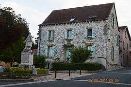 Asprières War Memorial | |
 Coat of arms | |
Location of Asprières 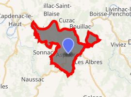
| |
 Asprières  Asprières | |
| Coordinates: 44°32′48″N 2°08′44″E | |
| Country | France |
| Region | Occitanie |
| Department | Aveyron |
| Arrondissement | Villefranche-de-Rouergue |
| Canton | Lot et Montbazinois |
| Intercommunality | CC Grand-Figeac - Haut-Ségala - Balaguier Olt |
| Government | |
| • Mayor (2014-2020) | Alain Casterot |
| Area 1 | 17.09 km2 (6.60 sq mi) |
| Population (2017-01-01)[1] | 733 |
| • Density | 43/km2 (110/sq mi) |
| Time zone | UTC+01:00 (CET) |
| • Summer (DST) | UTC+02:00 (CEST) |
| INSEE/Postal code | 12012 /12700 |
| Elevation | 167–546 m (548–1,791 ft) (avg. 430 m or 1,410 ft) |
| 1 French Land Register data, which excludes lakes, ponds, glaciers > 1 km2 (0.386 sq mi or 247 acres) and river estuaries. | |
The inhabitants of the commune are known as Aspriérois or Aspriéroises.[2]
Geography
Asprières is located some 10 km south-east of Figeac just east of Capdenac-Gare. Access to the commune is by the D40 road from Bouillac in the north-east passing south-west through the heart of the commune and the village and continuing south-west to Salles-Courbatiès. The D994 road from Capdenac-Gare passes down the western border of the commune then east to the village and onwards to Les Albres in the south-east. The tortuous D144 road from Bouillac to Les Albres passes through the neck of the commune in the north-east. A railway runs along the northern border of the commune going east from Capdenac-Gare but there is no station in the commune. The nearest station is in Bouillac. Apart from the village there are the hamlets of Bor, Vernet le Haut, La Coustille, Labrol, Querbes, Paysan, and La Montjouvie - all in the north of the commune - and La Marmiesse east of the village. The commune is mixed forest and farmland with particularly large forests in the north and north-east.[3]
The Lot river forms all of the northern border of the commune with the department of Lot on the other side of the river. The Lot flows from east to west eventually joining the Garonne north of Bordeaux. Several streams rise in the commune and flow north to join the Lot including the: Ruisseau de Prat Rigal, Ruisseau de Querbes, and the Ruisseau de Roucayrol. The Ruisseau de l'Estang forms the south-eastern border of the commune as it flows south-west to join the Ruisseau de Tournac which forms the southern border of the commune as it flows west.[3]
Neighbouring communes and villages[3]
Places adjacent to Asprières | |
|---|---|
History
In 1790 Asprières was the capital of a canton. In 1922 it lost its status as capital which was transferred to Capdenac-Gare.
Heraldry
Arms of Asprières |
Blazon: Azure, a tower of Argent turreted, masoned in Sable with port of Gules. |
Administration
List of Successive Mayors[4]
| From | To | Name | Party | Position |
|---|---|---|---|---|
| 1795 | 1799 | Pierre Frechet | ||
| 1800 | 1834 | Jean Baptiste Escudie | ||
| 1834 | 1838 | Joseph Gabriel Raynal | ||
| 1838 | 1839 | François Escudie | ||
| 1839 | 1843 | Jean Joulie | ||
| 1843 | 1848 | Jean Baptiste Andrieu | ||
| 1848 | 1848 | Augustin Delbies | ||
| 1848 | 1852 | François Escudie | ||
| 1852 | 1871 | Jean Baptiste Andrieu | ||
| 1871 | 1877 | Léon Piales | ||
| 1878 | 1892 | Auguste Escudie | ||
| 1892 | 1896 | Victor Aussel | ||
| 1896 | 1900 | Théophile Gazeau | ||
| 2001 | 2008 | Robert Marty | ||
| 2008 | 2013 | Alain Combes[5] | ||
| 2013 | 2014 | Jean Pierre Cantaloube | ||
| 2014 | 2020 | Alain Casterot |
(Not all data is known)
Demography
In 2010 the commune had 683 inhabitants. The evolution of the number of inhabitants is known from the population censuses conducted in the commune since 1793. From the 21st century, a census of communes with fewer than 10,000 inhabitants is held every five years, unlike larger towns that have a sample survey every year.[Note 1]
| 1793 | 1800 | 1806 | 1821 | 1831 | 1836 | 1841 | 1846 | 1851 |
|---|---|---|---|---|---|---|---|---|
| 578 | 685 | 1,418 | 1,512 | 1,443 | 1,459 | 1,464 | 1,643 | 1,620 |
| 1856 | 1861 | 1866 | 1872 | 1876 | 1881 | 1886 | 1891 | 1896 |
|---|---|---|---|---|---|---|---|---|
| 1,674 | 1,656 | 1,821 | 1,857 | 1,816 | 1,193 | 1,256 | 1,201 | 1,088 |
| 1901 | 1906 | 1911 | 1921 | 1926 | 1931 | 1936 | 1946 | 1954 |
|---|---|---|---|---|---|---|---|---|
| 989 | 912 | 896 | 883 | 859 | 774 | 715 | 675 | 678 |
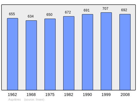
| 1962 | 1968 | 1975 | 1982 | 1990 | 1999 | 2006 | 2010 | - |
|---|---|---|---|---|---|---|---|---|
| 655 | 634 | 650 | 672 | 691 | 707 | 721 | 683 | - |
Sites and monuments
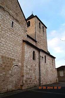
In the Parish Church of Saint-Martial is an item registered as a historical object:
- Painting and its frame: The last communion of Saint Jerome (1885)

Bibliography
- Christian-Pierre Bedel, preface by Jacques Dournes, Capdenac, Los Aures, Asprièras, Balaguièr, Bolhac, Causse-e-Diège, Foissac, Naussac, Salas, Sonnac / Christian-Pierre Bedel e los estatjants del canton de Capdenac, Rodez, Mission départementale de la culture, 1996, Al canton collection, 240 pages, ill., cover ill., 28 cm, ISBN 2-907279-23-8, ISSN 1151-8375, BnF 36688708h (Occitan) (in French)
See also
External links
- Asprières on Lion1906
- Asprières on Google Maps
- Asprières on Géoportail, National Geographic Institute (IGN) website (in French)
- Asprieres on the 1750 Cassini Map
- Asprières on the INSEE website (in French)
- INSEE (in French)
Notes and references
Notes
- At the beginning of the 21st century, the methods of identification have been modified by Law No. 2002-276 of 27 February 2002 Archived 6 March 2016 at the Wayback Machine, the so-called "law of local democracy" and in particular Title V "census operations" allows, after a transitional period running from 2004 to 2008, the annual publication of the legal population of the different French administrative districts. For communes with a population greater than 10,000 inhabitants, a sample survey is conducted annually, the entire territory of these communes is taken into account at the end of the period of five years. The first "legal population" after 1999 under this new law came into force on 1 January 2009 and was based on the census of 2006.
References
- "Populations légales 2017". INSEE. Retrieved 6 January 2020.
- Inhabitants of Aveyron (in French)
- Google Maps
- List of Mayors of France (in French)
- The Mayor Alain Combres is deceased, 6 August 2013, ladepeche.fr website, consulted on 16 October 2013 (in French)
- Ministry of Culture, Palissy IM12000210 Painting and its frame: The last communion of Saint Jerome (in French)
| Wikimedia Commons has media related to Asprières. |