Auriac-Lagast
Auriac-Lagast is a commune in the Aveyron department in the Occitanie region of southern France.
Auriac-Lagast | |
|---|---|
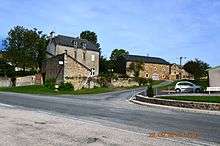
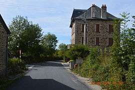 The road into Auriac-Lagast | |
Location of Auriac-Lagast 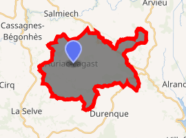
| |
 Auriac-Lagast  Auriac-Lagast | |
| Coordinates: 44°08′50″N 2°34′52″E | |
| Country | France |
| Region | Occitanie |
| Department | Aveyron |
| Arrondissement | Millau |
| Canton | Monts du Réquistanais |
| Intercommunality | CC Réquistanais |
| Government | |
| • Mayor (2014-2020) | Yves Latieule |
| Area 1 | 30.76 km2 (11.88 sq mi) |
| Population (2017-01-01)[1] | 229 |
| • Density | 7.4/km2 (19/sq mi) |
| Time zone | UTC+01:00 (CET) |
| • Summer (DST) | UTC+02:00 (CEST) |
| INSEE/Postal code | 12015 /12120 |
| Elevation | 574–930 m (1,883–3,051 ft) (avg. 680 m or 2,230 ft) |
| 1 French Land Register data, which excludes lakes, ponds, glaciers > 1 km2 (0.386 sq mi or 247 acres) and river estuaries. | |
The inhabitants of the commune are known as Aurigastois or Aurigastoises.[2]
Geography
Auriac-Lagast is located some 27 km south of Rodez and 35 km north by north-east of Carmaux. Access to the commune is by the D522 road from Cassagnes-Bégonhès in the north-west which passes through the heart of the commune and the village and continues south-east to Durenque. The D25 passes inside the eastern border of the commune as it goes from Salmiech to Villefranche-de-Panat. Apart from the village there are the hamlets of:
- Belle Sagne,
- Belvezet,
- La Cailholie,
- Castanies,
- La Garde,
- Ginestous,
- La Malborie,
- Moncan,
- Saint-Leon,
- Le Roube,
- La Roque,
- Randan,
- Les Salettes,
The commune is almost entirely farmland with a few forests.[3]
The Gladou river rises in the east of the commune and flows west forming part of the western border as it then flows north to join the Céar south of Cassagnes-Bégonhès. The Hunargues and the Ruisseau des Gazelles also rise in the commune and flow west to join the Gladou in the commune. The Ruisseau du Lagast rises in the south-eastern corner of the commune and forms most of the eastern border as it flows north to join the Céor. The Ruisseau de Miège Sole crosses the eastern arm of the commune and forms part of the northern border of the arm before continuing north to join the Ruisseau du Lagast just north of the commune.[3]
Neighbouring communes and villages[3]
Places adjacent to Auriac-Lagast | |
|---|---|
Administration
List of Successive Mayors[4]
| From | To | Name | Party | Position |
|---|---|---|---|---|
| 1833 | 1837 | Etienne Moudon | ||
| 1837 | 1838 | Adolphe Bonnefous | ||
| 1838 | 1848 | Hercule Bonnefous | ||
| 1848 | 1853 | Marie Henri Régis Bonnefous | ||
| 1853 | 1865 | Raymond Seguret | ||
| 1865 | 1883 | Henri Urbain Molnier | ||
| 2001 | 2008 | Yves Letieule | ||
| 2008 | 2014 | Jean Garrigues | ||
| 2014 | 2020 | Yves Latieule |
(Not all data is known)
Demography
In 2010 the commune had 241 inhabitants. The evolution of the number of inhabitants is known from the population censuses conducted in the commune since 1793. From the 21st century, a census of communes with fewer than 10,000 inhabitants is held every five years, unlike larger towns that have a sample survey every year.[Note 1]
| 1793 | 1800 | 1806 | 1821 | 1831 | 1836 | 1841 | 1846 | 1851 |
|---|---|---|---|---|---|---|---|---|
| 422 | 531 | - | - | - | 533 | 648 | 571 | 552 |
| 1856 | 1861 | 1866 | 1872 | 1876 | 1881 | 1886 | 1891 | 1896 |
|---|---|---|---|---|---|---|---|---|
| 527 | 538 | 585 | 616 | 583 | 614 | 600 | 612 | 620 |
| 1901 | 1906 | 1911 | 1921 | 1926 | 1931 | 1936 | 1946 | 1954 |
|---|---|---|---|---|---|---|---|---|
| 615 | 617 | 608 | 584 | 593 | 636 | 659 | 652 | 558 |
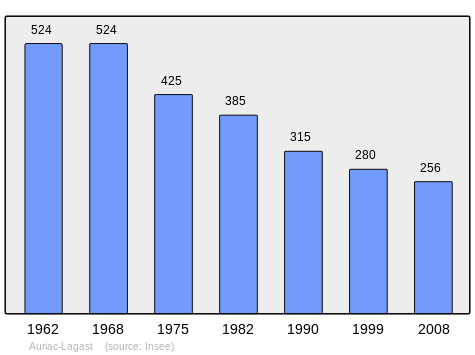
| 1962 | 1968 | 1975 | 1982 | 1990 | 1999 | 2006 | 2010 | - |
|---|---|---|---|---|---|---|---|---|
| 524 | 524 | 425 | 385 | 315 | 280 | 265 | 241 | - |
Distribution of Age Groups
Percentage Distribution of Age Groups in Auriac-Lagast and Aveyron Department in 2010
| Auriac | Auriac | Aveyron | Aveyron | |
|---|---|---|---|---|
| Age Range | Men | Women | Men | Women |
| 0 to 14 Years | 11.8 | 14.6 | 16.7 | 15.0 |
| 15 to 29 Years | 14.5 | 18.0 | 14.8 | 13.2 |
| 30 to 44 Years | 12.7 | 10.6 | 18.6 | 17.4 |
| 45 to 59 Years | 29.1 | 23.6 | 21.4 | 20.3 |
| 60 to 74 Years | 14.5 | 16.3 | 17.4 | 17.8 |
| 75 to 89 Years | 17.3 | 19.5 | 10.4 | 14.4 |
| 90 Years+ | 0.0 | 1.6 | 0.6 | 1.8 |
Sources:
Sites and monuments
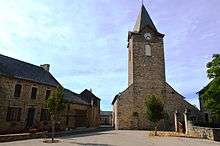
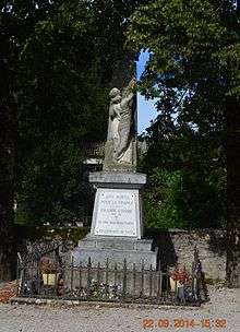
- The Parish Church of Saint-Léonard of Auriac: its steeple was struck by lightning and restored.
- Moncan (private area)
- The Chateau of Randan (private property - owned by the family of Raymond Bonnefous)
See also
Bibliography
- Christian-Pierre Bedel, preface by Bernard Destours, Cassanhas, Arviu, Auriac, Caumont, La Grand'Vila, Saumièg, Senta-Jaleda / Christian-Pierre Bedel e los estatjants del canton de Cassanhas, Rodez, Mission départementale de la culture, 1996, Al canton collection, 240 pages, ill., cov. ill., 28 cm, ISBN 2-907279-30-0, ISSN 1151-8375, BnF 366930046 (in Occitan and French)
External links
- Auriac-Lagast on Lion1906
- Auriac-Lagast on Google Maps
- Auriac-Lagast on Géoportail, National Geographic Institute (IGN) website (in French)
- Auriac on the 1750 Cassini Map
- Auriac-Lagast on the INSEE website (in French)
- INSEE (in French)
Notes and references
Notes
- At the beginning of the 21st century, the methods of identification have been modified by Law No. 2002-276 of 27 February 2002 Archived 6 March 2016 at the Wayback Machine, the so-called "law of local democracy" and in particular Title V "census operations" allows, after a transitional period running from 2004 to 2008, the annual publication of the legal population of the different French administrative districts. For communes with a population greater than 10,000 inhabitants, a sample survey is conducted annually, the entire territory of these communes is taken into account at the end of the period of five years. The first "legal population" after 1999 under this new law came into force on 1 January 2009 and was based on the census of 2006.
References
- "Populations légales 2017". INSEE. Retrieved 6 January 2020.
- Inhabitants of Aveyron (in French)
- Google Maps
- List of Mayors of France (in French)
| Wikimedia Commons has media related to Auriac-Lagast. |
| Authority control |
|
|---|