La Bastide-Pradines
La Bastide-Pradines is a French commune in the Aveyron department in the Occitanie region of southern France.[2]
La Bastide-Pradines | |
|---|---|
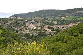 A general view of La Bastide-Pradines | |
Location of La Bastide-Pradines 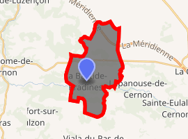
| |
 La Bastide-Pradines  La Bastide-Pradines | |
| Coordinates: 44°00′09″N 3°02′50″E | |
| Country | France |
| Region | Occitanie |
| Department | Aveyron |
| Arrondissement | Millau |
| Canton | Saint-Affrique |
| Intercommunality | Larzac-Templier Causses et Vallées |
| Government | |
| • Mayor (2008–2014) | Agnès Comby |
| Area 1 | 20.56 km2 (7.94 sq mi) |
| Population (2017-01-01)[1] | 101 |
| • Density | 4.9/km2 (13/sq mi) |
| Time zone | UTC+01:00 (CET) |
| • Summer (DST) | UTC+02:00 (CEST) |
| INSEE/Postal code | 12022 /12490 |
| Elevation | 460–862 m (1,509–2,828 ft) (avg. 574 m or 1,883 ft) |
| 1 French Land Register data, which excludes lakes, ponds, glaciers > 1 km2 (0.386 sq mi or 247 acres) and river estuaries. | |
The inhabitants of the commune are known as Bastidois or Bastidoises.[3]
Geography
La Bastide-Pradines is located some 50 km south-east of Rodez and 10 km north-east of Saint-Affrique in the heart of the Parc naturel régional des Grands Causses. Access to the commune is by the A75 autoroute which passes through the north of the commune from north-west to east with Exit ![]()
![]()
The Cernon river flows through the commune and the village from east to west and continues west then north joining the Tarn east of Comprégnac. The Ruisseau de Coufours rises in the north of the commune and flows south to join the Cernon near the village. The Ruisseau de Saute-Bouc rises in the north-east of the commune and flows south-west to join the Ruisseau de Coufours just north of the village. The Ruisseau des Clarous rises in the south of the commune and flows north to join the Cernon.[4][5]
Neighbouring communes and villages[4] | |
|---|---|
Toponymy
La Bastide-Pradines appears as la Baftide de Pradines on the 1750 Cassini Map[6] and as la Bastide de Pradines on the 1790 version.[7]
History
Formerly called La Bastide de Sernonenque, La Bastide-Pradines was once a Commandry of the Knights Hospitaller.
Administration
| From | To | Name |
|---|---|---|
| 1793 | 1795 | Antoine Bosc |
| 1795 | 1800 | Joseph Calvet |
| 1801 | 1815 | Jean Pierre Vernhes |
| 1816 | 1858 | Louis Marie Antoine Gasc de la Gineste |
| 1859 | 1865 | Auguste Soutou |
| 1865 | 1871 | Gédéon Joseph Paul Caylet |
| 1871 | 1876 | Pierre Gazel |
| 1876 | 1886 | Benjamin Sigaud |
| 1886 | 1888 | Etienne Lacoste |
| 1888 | 1896 | Gualy de la Gineste |
| 1896 | 1900 | Auguste Malzac |
| 1900 | 1908 | Auguste Malzac |
| 1908 | 1925 | Jules Soutou |
- Mayors from 1925
| From | To | Name | Party | Position |
|---|---|---|---|---|
| 1925 | 1956 | Emile de Gualy | ||
| 1956 | 1977 | Gabriel Malric | ||
| 1977 | 1983 | Augustin Mailhe | ||
| 1983 | 1995 | Alain Arnal | ||
| 2001 | 2008 | Emilien Boutonnet | ||
| 2008 | 2014 | Agnès Comby | ||
| 2014 | 2020 | Yves Malric |
(Not all data is known)
Demography
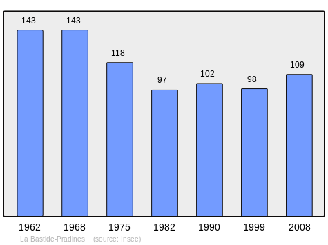
In 2010 the commune had 111 inhabitants. The evolution of the number of inhabitants is known from the population censuses conducted in the commune since 1793. From the 21st century, a census of communes with fewer than 10,000 inhabitants is held every five years, unlike larger communes that have a sample survey every year.[Note 1]
| 1793 | 1800 | 1806 | 1821 | 1831 | 1836 | 1841 | 1846 | 1851 |
|---|---|---|---|---|---|---|---|---|
| 347 | 417 | - | - | - | - | 467 | 486 | 463 |
| 1856 | 1861 | 1866 | 1872 | 1876 | 1881 | 1886 | 1891 | 1896 |
|---|---|---|---|---|---|---|---|---|
| 466 | 455 | 435 | 480 | 446 | 463 | 929 | 543 | 385 |
| 1901 | 1906 | 1911 | 1921 | 1926 | 1931 | 1936 | 1946 | 1954 |
|---|---|---|---|---|---|---|---|---|
| 345 | 332 | 333 | 253 | 258 | 257 | 235 | 189 | 163 |
| 1962 | 1968 | 1975 | 1982 | 1990 | 1999 | 2006 | 2010 | - |
|---|---|---|---|---|---|---|---|---|
| 143 | 143 | 118 | 97 | 102 | 98 | 106 | 111 | - |
Sites and Monuments
- The Granieyras, a fortified granary dating from the 14th century, at the time of the Knights Hospitaller.
- Houses from the 12th century.
- A Two-arch Bridge 17.60 m long, one arch forming a slight donkeyback and the other semicircular.
Notable people linked to the commune
- Emma Calvé, singer, has stayed at La Bastide-Pradines with her aunt.
Bibliography
- Christian-Pierre Bedel, preface by Jean-Luc Malet, Sent-Africa, La Bastida, Caumèls-e-Lo Vialar, Ròcafòrt, Sant-Faliç, Sent-Esèri, Sent-Jan, D'Aucàpias, Sent-Roma de Sarnon, Tornamira, Vabre, Verzòls-e-La Pèira / Christian-Pierre Bedel e los estatjants del canton de Sent-Africa, Rodez, Mission départementale de la culture, 2002, Al canton collection, 429 pages, ill., cov. ill. 28 cm, ISBN 2-907279-54-8, ISSN 1151-8375, BnF 38977452h (in Occitan)
See also
Notes and references
Notes
- At the beginning of the 21st century, the methods of identification have been modified by Law No. 2002-276 of 27 February 2002, the so-called "law of local democracy" and in particular Title V "census operations" allows, after a transitional period running from 2004 to 2008, the annual publication of the legal population of the different French administrative districts. For communes with a population greater than 10,000 inhabitants, a sample survey is conducted annually and the entire territory of these communes is taken into account at the end of the period of five years. The first "legal population" after 1999 under this new law came into force on 1 January 2009 and was based on the census of 2006.
References
- "Populations légales 2017". INSEE. Retrieved 6 January 2020.
- La Bastide-Pradines on Lion1906
- Inhabitants of Aveyron (in French)
- La Bastide-Pradines on Google Maps
- La Bastide-Pradines on the Géoportail from National Geographic Institute (IGN) website (in French)
- la Baftide de Pradines on the 1750 Cassini Map
- la Bastide de Pradines on the 1790 Cassini Map
- List of Mayors of France (in French)
| Wikimedia Commons has media related to La Bastide-Pradines. |
| Authority control |
|
|---|