Mihalgazi
Mihalgazi, formerly Gümele (Before 1927), is a town and district of Eskişehir Province in the Black Sea Anatolia region of Turkey. According to 2010 census, population of the district is 3,876 of which 1,730 live in the town of Mihalgazi.[3][4] The district covers an area of 131 km2 (51 sq mi), and the town lies at an average elevation of 328 m (1,076 ft). She borders İnhisar to the west, Yenipazar to the northwest, Sarıcakaya to the east and Tepebaşı (Eskişehir) to the south. Mihalgazi has four boroughs and five villages. Alpagut and Sakarılıca, who are 2 of these villages, have a municipality. She 35 km away from Eskişehir. She was part of Eskişehir sanjak between 1292- second half of 15th century. She was part of Göynük township of Bursa sanjak between second half of 15th one - 16th one, her of Bolu sanjak between 16th century - 1894. She bounded to İnhisar nahiya in Söğüt township of Bilecik sanjak between 1894–1923. She was part of Söğüt district of Bilecik Province between 1923-1946 and became a township and changed her name as Mihalgazi in 1927 after People of Gümele repulsed attacks of Greeks troops, who marched from Söğüt and Eskişehir during Turkish War of Independence in 1921. She bounded to Central District of Eskişehir Province in 1946[5] and Sarıcakaya district of her in 1958. She had a municipality in 1967. She finally a district of Eskişehir Province in 1990. She is famous with hot spring in Sakarılıca.
Mihalgazi | |
|---|---|
District | |
 Location of Mihalgazi within Turkey. | |
 Mihalgazi Location of Mihalgazi within Turkey. | |
| Coordinates: 40°01′N 30°34′E | |
| Country | |
| Region | Central Anatolia |
| Province | Eskişehir |
| Government | |
| • Governor | Selim Palamut |
| Area | |
| • District | 130.83 km2 (50.51 sq mi) |
| Elevation | 328 m (1,076 ft) |
| Population (2012)[2] | |
| • Urban | 1,515 |
| • District | 3,505 |
| • District density | 27/km2 (69/sq mi) |
| Time zone | UTC+2 (EET) |
| • Summer (DST) | UTC+3 (EEST) |
| Postal code | 26xxx |
| Area code(s) | 0222 |
| Licence plate | 26 |
| Website | www.mihalgazi.gov.tr |
Notes
- "Area of regions (including lakes), km²". Regional Statistics Database. Turkish Statistical Institute. 2002. Retrieved 2013-03-05.
- "Population of province/district centers and towns/villages by districts - 2012". Address Based Population Registration System (ABPRS) Database. Turkish Statistical Institute. Retrieved 2013-02-27.
- Statistical Institute
- GeoHive. "Statistical information on Turkey's administrative units". Archived from the original on 2007-10-19. Retrieved 2008-04-05.
- http://www.resmigazete.gov.tr/arsiv/6279.pdf
References
- Falling Rain Genomics, Inc. "Geographical information on Mihalgazi, Turkey". Retrieved 2008-04-05.
- Governorship of Eskişehir, Directorate of Provincial Environment and Forestry (2006). "Environmental Status Report for Eskişehir Province" (PDF) (in Turkish). Archived from the original (PDF) on March 5, 2009. Retrieved 2008-04-05.
External links
- District governor's official website (in Turkish)
- District municipality's official website (in Turkish)
- Map of Mihalgazi district
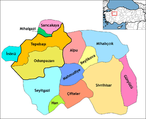
Mihalgazi in Eskişehir Province of Turkey | |||||||||||||||||||||||||||
|---|---|---|---|---|---|---|---|---|---|---|---|---|---|---|---|---|---|---|---|---|---|---|---|---|---|---|---|
| Districts | Districts of Eskişehir | ||||||||||||||||||||||||||
| |||||||||||||||||||||||||||
Metropolitan municipalities are bolded. | |||||||||||||||||||||||||||
| |||||||||||||||||||
| |||||||||||||||||||
| |||||||||||||||||||
| |||||||||||||||||||