Sakarya River
The Sakarya (Turkish: Sakarya Irmağı; Greek: Σαγγάριος, romanized: Sangarios; Latin: Sangarius) is the third longest river in Turkey. It runs through the region known in ancient times as Phrygia. It was considered one of the principal rivers of Asia Minor (Anatolia) in classical antiquity, and is mentioned in the Iliad[1] and in Theogony.[2] Its name appears in different forms as Sagraphos,[3] Sangaris,[4] or Sagaris.[5]
| Sakarya River | |
|---|---|
 | |
| Location | |
| Country | Turkey |
| Physical characteristics | |
| Source | |
| ⁃ location | Bayat Plateau |
| Mouth | |
⁃ location | Black Sea |
| Length | 824 km (512 mi) |
| Basin size | 55,300 km2 (21,400 sq mi) |
| Discharge | |
| ⁃ average | 193 m3/s (6,800 cu ft/s) |
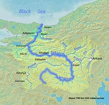
In Geographica, Strabo wrote that during classical antiquity, the river had its sources on Mount Adoreus, near the town of Sangia in Phrygia, not far from the Galatian frontier,[6] and flowed in a very tortuous course, first in an eastern, then in a northern, then in a northwestern, and lastly again in a northern direction through Bithynia into the Euxine (Black Sea). In one part of its course it formed the boundary between Phrygia and Bithynia; and in early times Bithynia was bounded on the east by the river. The Bithynian part of the river was navigable, and was celebrated for the abundance of fish found in it. Its principal tributaries were the Alander, Bathys, Thymbres, and Gallus.[7]
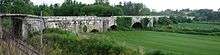
The source of the river is the Bayat Yaylası (Bayat Plateau) which is located to the northeast of Afyon. Joined by the Porsuk Çayı (Porsuk Creek) close to the town of Polatlı, the river runs through the Adapazarı Ovası (Adapazarı Plains) before reaching the Black Sea. The Sakarya was once crossed by the Sangarius Bridge, constructed by the East Roman Emperor Justinian I (r. 527–565).
In the 13th century, the valley of the Sakarya was part of the frontier between the Byzantine Empire and the home of the Söğüt tribe. By 1280, Byzantine Emperor Michael VIII had constructed a series of fortifications along the river to control the area, but a flood in 1302 changed the course of the river and made the fortifications useless.[8] The Söğüt tribe migrated across the river and went on to establish the Ottoman Empire.
From downstream to upstream, the Sakarya has four dams: Akçay, Yenice, Gökçekaya and Sarıyar.
References
- Homer. Iliad. 3.187, 16.719.
- Hesiod, Theogony, 344.
- Schol. ad Apollon. Rhod. 2.724.
- Constantine VII, De Administrando Imperio 1.5
- Ovid, ex Pont. 4.10 17; Solin 43; Pliny. Naturalis Historia. 6.1.
- Strabo. Geographica. xii. p.543. Page numbers refer to those of Isaac Casaubon's edition.
- Periplus of Pseudo-Scylax, p. 34; Apollon. 2.724; Scymnus. 234, foil.; Strab. xii. pp. 563, 567; Dionys. Perieg. 811; Ptol. 5.1.6; Steph. B. sub voce Liv. 38.18; Plin. Nat. 5.43; Amm. Marc. 22.9.
- Imber, Colin. The Ottoman Empire, 1300-1650 : the structure of power (Third ed.). London. p. 6. ISBN 1352004968. OCLC 1034613389.
![]()
See also
| Wikimedia Commons has media related to Sakarya river. |
| Authority control |
|
|---|