Han, Eskişehir
Han, formerly Hanköy and Hüsrevpaşa, is a town and district of Eskişehir Province in the Central Anatolia region of Turkey. According to a 2010 census, population of the district is 2,165 of which 1,057 live in the town of Han.[3][4] The district covers an area of 250 km2 (97 sq mi), and the town lies at an average elevation of 1,207 m (3,960 ft).
Han | |
|---|---|
District | |
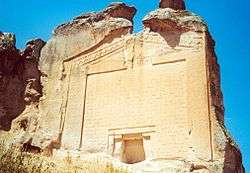 Midas Tomb in Yazılıkaya village | |
 Location of Han, Eskişehir within Turkey. | |
 Han Location of Han, Eskişehir within Turkey. | |
| Coordinates: 39°10′N 30°52′E | |
| Country | |
| Region | Central Anatolia |
| Province | Eskişehir |
| Government | |
| • Governor | Veysel Yüksel |
| • Mayor | Mustafa Pekak (AKP) |
| Area | |
| • District | 249.57 km2 (96.36 sq mi) |
| Elevation | 1,207 m (3,960 ft) |
| Population (2012)[2] | |
| • Urban | 1,059 |
| • District | 2,108 |
| • District density | 8.4/km2 (22/sq mi) |
| Time zone | UTC+2 (EET) |
| • Summer (DST) | UTC+3 (EEST) |
| Postal code | 26xxx |
| Area code(s) | 0222 |
| Licence plate | 26 |
| Website | www.han.gov.tr |
Notes
- "Area of regions (including lakes), km²". Regional Statistics Database. Turkish Statistical Institute. 2002. Retrieved 2013-03-05.
- "Population of province/district centers and towns/villages by districts - 2012". Address Based Population Registration System (ABPRS) Database. Turkish Statistical Institute. Retrieved 2013-02-27.
- Statistical Institute
- GeoHive. "Statistical information on Turkey's administrative units". Retrieved 2008-04-04.
References
- Falling Rain Genomics, Inc. "Geographical information on Hanköy, Turkey". Retrieved 2008-04-04.
- Governorship of Eskişehir, Turkey. "General information on Han, Eskişehir" (in Turkish). Archived from the original on 2010-11-26. Retrieved 2008-04-04.
- Governorship of Eskişehir, Directorate of Provincial Environment and Forestry (2006). "Environmental Status Report for Eskişehir Province" (PDF) (in Turkish). Archived from the original (PDF) on 2009-03-05. Retrieved 2008-04-04.
External links
- District governor's official website (in Turkish)
- Map of Han district
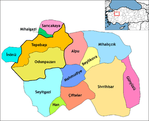
Han, Eskişehir in Eskişehir Province of Turkey | |||||||||||||||||||||||||||
|---|---|---|---|---|---|---|---|---|---|---|---|---|---|---|---|---|---|---|---|---|---|---|---|---|---|---|---|
| Districts | Districts of Eskişehir | ||||||||||||||||||||||||||
| |||||||||||||||||||||||||||
Metropolitan municipalities are bolded. | |||||||||||||||||||||||||||
| |||||||||||||||||||
| |||||||||||||||||||
| |||||||||||||||||||
| |||||||||||||||||||
This article is issued from Wikipedia. The text is licensed under Creative Commons - Attribution - Sharealike. Additional terms may apply for the media files.