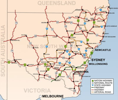
List of road routes in New South Wales
Road routes in New South Wales assist drivers navigating roads in urban, rural, and scenic areas of the state. Today, all numbered routes in the state are allocated a letter (M, A or B) in addition to a one- or -two digit number, with 'M' routes denoting motorways, 'A' routes denoting routes of national significance, and 'B' routes denoting routes of state significance. The route system includes the officially designated highways, urban and intercity motorways and arterial roads, and important cross-state roads that have not been declared highways.

History
Route numbers have been allocated to NSW roads since 1955. National Route 1 ('Highway 1') was one of the best known numbered national routes, likely because of its fame for circumnavigating the continent. The insignia of national routes was a five-sided black and white shield, chosen as it is the shape of the Australian national coat of arms.
To supplement the national route number system, three ring roads were introduced to Sydney in 1964.[1] These were numbered 1, 3 and 5, with relatively (but not proportionately) increasing radii. While they were officially decommissioned in 1974, some old ring road 3 signs remained posted into the 1980s, and ring road 1 signs into the 1990s.
In 1973, a system of freeway numbering was introduced to the state to complement the national routes and ring roads. The shields were replicas of the red, white and blue U.S. Interstate Highway shields, and were numbered F1 to F8:
- F1: Warringah Freeway, and its never-built extensions
- F2: reserved for the Castlereagh Freeway, a corridor similar to today's M2 Hills Motorway
- F3: Sydney–Newcastle Freeway (now Pacific Motorway), and the never-built Lane Cove Valley Expressway and North Western Expressway
- F4: Western part of today's M4 Western Motorway (formerly Western Freeway)
- F5: the freeway section of National Highway 31 (now Hume Motorway)
- F6: Southern Freeway (now Princes Motorway), and its never-built extensions to the Sydney CBD
- F7: reserved for a corridor similar to today's Cahill Expressway, Eastern Distributor and Bondi Junction Bypass
- F8: a section of Wollongong's Northern Distributor (now Memorial Drive)[2]
Most of these routes were replaced with other numbers over the decades, and by the 1990s, only the F1, F3 and F6 were still marked as such, with simpler, green-on-white shields. None of these shields remain, but the F3 and F6 are still usually called by those names.
In 1974, the National Highway network was defined, which in New South Wales included the Hume Highway, Federal Highway, Barton Highway, Sydney-Newcastle Freeway (now Pacific Motorway) and New England Highway.[3] National highways were marked with the same shield as the national routes, except for their green and gold colour and the word 'national' added across the top.
Also in 1974, the three ring roads, 1, 3 and 5, were decommissioned and replaced by new State Routes, which had the same shields as the new freeways but without the red crest. Scores of other State Routes were also designated across New South Wales, marking out urban arterial routes and secondary rural highways. They were allocated as follows:
- 11, 33 and 55: Respectively replaced ring roads 1, 3 and 5. In 1988, state route 77 was commissioned as an additional primary circumferential route.
- 12-76: Greater Sydney. Even numbers were radial while odd numbers were circumferential, roughly increasing in value anticlockwise around the City. Exceptions were State Route 31 (which replaced Metroad 5 when the South Western Motorway was extended easterly; Metroad 5 was a replacement of the metropolitan part of National Highway 31) and state route 60 (which is in Wollongong). Routes 36, 40, 56, 68 and 69 extended beyond the bounds of Greater Sydney. While most State Routes still appear on maps and in street directories, they were haphazardly removed and covered up in Sydney in 1998 and 2004, leaving only routes 29, 31, 40, 44, 54, 56, 60 and 69.
- 78-99: Rural Areas. There was no discernible pattern with these routes. State route 83 was commissioned in 1979 and state route 89 was commissioned in 1980.
- 111, 121-124, 128, 131-133, 135: Greater Newcastle. 111 was added in 1988 following National Highway 1's relocation to the F3 Freeway.
- 151, 153, 155 and 157: Greater Wollongong, in addition to state routes 60, 68, 69 and 88.
- 2: In 2008, Queensland's state route 2 from the Gold Coast was extended a short distance into far northern NSW.
In 1993, Sydney's Metroad system was introduced, with its prominent, blue-on-white hexagonal shields. There were initially six metroads: Metroad 1 replaced National Route 1 within the metropolitan area, Metroad 2 replaced parts of State Routes 28 and 30 (and was subsequently absorbed by the M2 Hills Motorway), Metroad 3 replaced State Route 33 (once Ring Road 3), Metroad 4 replaced the F4 Freeway and the metropolitan part of National Route 32, Metroad 5 replaced part of the metropolitan part of National Highway 31 and Metroad 7 replaced State Route 77. Later, Metroad 6 replaced State Route 45, Metroad 9 replaced the metropolitan part of State Route 69 and Metroad 10 replaced State Route 14 south of Mona Vale. There was never a Metroad 8.
In 2013, the state replaced its entire system of State Routes, National Routes, National Highways and Metroads with an alphanumeric route numbering system.[4] All numbered routes are allocated a letter (M, A or B) in addition to its number, with 'M' routes denoting motorways, 'A' routes denoting routes of national significance, and 'B' routes denoting routes of state significance. Instead of shields, the route numbers are displayed as yellow text on green rectangular background outlined in white. The changeover to alphanumeric routes was announced from March 2013 and signs were updated throughout 2013, either by removing old "shield" coverplates installed on newer signs, or installing new alphanumeric coverplates on old shielded signs. In 2020, the styling of the markers was modified to remove the white border, aligning with all other states except the ACT.[5]
Motorways (M routes)
| Route | Component roads | From | To | Length | Notes |
|---|---|---|---|---|---|
M1 |
Pacific Motorway | Queensland border | Ballina | 89 km (55 mi) | |
| Pacific Motorway | Dirty Creek | Sapphire Beach | 35 km (22 mi) | ||
| Pacific Motorway | Bonville | Thrumster | 141 km (88 mi) | ||
| Pacific Motorway | Newcastle | Wahroonga | 127 km (79 mi) | ||
| Gore Hill Freeway | Artarmon | Naremburn | 3 km (2 mi) | ||
| Warringah Freeway | Naremburn | North Sydney | 4 km (2 mi) | ||
| Sydney Harbour Tunnel | North Sydney | Sydney (City) | 2.8 km (2 mi) | TOLL Citybound | |
| Cahill Expressway | Sydney | Woolloomooloo | 900 m (984 yd) | ||
| Eastern Distributor | Woolloomooloo | Kensington | 6 km (4 mi) | TOLL Citybound | |
| Princes Motorway | Waterfall | Yallah | 53 km (33 mi) | ||
M2 |
Lane Cove Tunnel | Artarmon | North Ryde | 3.6 km (2 mi) | TOLL |
| Hills Motorway | North Ryde | Seven Hills | 21 km (13 mi) | TOLL | |
M4 |
Western Motorway | North Strathfield | Lapstone | 46 km (29 mi) | TOLL from North Strathfield to Merrylands |
| M4 East | Homebush | Haberfield | 5.5 km (3 mi) | TOLL | |
M5 |
M5 East | Mascot | Berverly Hills | 10 km (6 mi) | |
| South-West Motorway | Beverly Hills | Prestons | 21 km (13 mi) | TOLL from Beverly Hills to Glenfield | |
M7 |
Westlink M7 | Prestons | Seven Hills | 40 km (25 mi) | TOLL |
M8 |
M8 Motorway | Kingsgrove | St Peters | 9 km (6 mi) | TOLL |
M15 |
Hunter Expressway | Cameron Park | Belford | 39 km (24 mi) | |
M23 |
Federal Highway | Yarra | ACT border | 66 km (41 mi) | Not a Motorway |
M31 |
Hume Motorway | Prestons (Sydney) | Berrima | 86 km (53 mi) | |
| Hume Highway | Berrima | Victorian Border | 425 km (264 mi) | Not a Motorway |
Routes of national significance (A routes)
| Route | Component roads | From | To | Length | Notes |
|---|---|---|---|---|---|
A1 |
Pacific Highway | Ballina | Dirty Creek | 161 km (100 mi) | |
| Pacific Highway | Sapphire Beach | Bonville | 16 km (10 mi) | ||
| Pacific Highway | Thrumster | Hexham | 218 km (135 mi) | ||
| Pacific Highway (Sydney) | Wahroonga | Artarmon | 15 km (9 mi) | ||
| General Holmes Drive
The Grand Parade |
Kyeemagh | Brighton-Le-Sands | 3 km (5 mi) | ||
| President Avenue | Brighton-Le-Sands | Kogarah | 2 km (3 mi) | ||
| Princes Highway | Kogarah | Waterfall | 28 km (17 mi) | ||
| Princes Highway | Albion Park | NSW-Vic Border | 420 km (261 mi) | ||
A2 |
Old Windsor Road | Seven Hills | Windsor | 21 km (13 mi) | |
A3 |
Mona Vale Road
Devlin Street Church Street Concord Road Homebush Bay Drive Centenary Drive Roberts Road |
Mona Vale | Blakehurst | 52 km (32 mi) | |
A4 |
Bradfield Highway
City West Link Road Dobroyd Parade Wattle Street |
North Sydney | Ashfield | 12 km (7 mi) | TOLL on Bradfield Highway |
A6 |
Marsden Road | Carlingford | West Ryde | 2 km (1 mi) | |
| Stewart Street
Kissing Point Road |
West Ryde | Dundas Valley | 850 m (930 yd) | ||
| Silverwater Road | Dundas Valley | Auburn | 6 km (4 mi) | ||
| Boorea Street
Olympic Drive Joseph Street Rookwood Road Stacey Street Fairford Road Davies Road Alfords Point Road New Illawara Road |
Auburn | Lucas Heights | 26 km (16 mi) | ||
| Heathcote Road | Lucas Heights | Engadine | 5 km (3 mi) | ||
A8 |
Pittwater Road
Condamine Street Manly Road Spit Road |
Mona Vale | Mosman | 20 km (12 mi) | |
| Military Road | Mosman | North Sydney | 3 km (2 mi) | ||
A9 |
Narellan Road
The Northern Road Parker Street |
Campbelltown | Cranebrook | 59 km (37 mi) | |
| The Northern Road | Llandilo | Berkshire Park | 8 km (5 mi) | ||
| Richmond Road | Berkshire Park | Londonderry | 250 m (273 yd) | ||
| George Street
Macquarie Street |
South Windsor | Windsor | 5 km (3 mi) | ||
A15 |
New England Highway | Branxton | Queensland Border | 541 km (336 mi) | |
|
Cameron Park | Newcastle West | 15 km (9 mi) | ||
A20 |
Sturt Highway | Gundagai | Victoria Border | 597 km (371 mi) | |
A22 |
Parramatta Road | Chippendale | Summer Hill | 6 km (4 mi) | |
| Hume Highway
Liverpool Road Sydney Road |
Summer Hill | Liverpool | 30 km (19 mi) | ||
A25 |
Barton Highway | ACT border | Yass | 40 km (25 mi) | |
A28 |
Cumberland Highway | Wahroonga | Prestons | 42 km (26 mi) | |
A32 |
Barrier Highway | Lapstone | Cockburn | 1,146 km (712 mi) | |
A34 |
Milperra Road
Canterbury Road New Canterbury Road |
Liverpool | Newtown | 26 km (16 mi) | |
A36 |
Princes Highway | Kogarah | Sydney | 11 km (7 mi) | |
A37 |
Newcastle Inner City Bypass | Windale | Sandgate | 16 km (10 mi) | |
A38 |
Delhi Road
Millwood Avenue Fullers Road Boundary Street Baggage Road Warringah Road |
North Ryde | Dee Why | 18 km (11 mi) | |
A39 |
Newell Highway | Victoria border | Queensland border | 1,059 km (658 mi) | |
A40 |
Victoria Road | Rozelle | West Baulkham Hills | 29 km (18 mi) | |
A41 |
Mid-Western Highway | Bathurst | Albury | 423 km (263 mi) | |
A43 |
New England Highway
Pacific Highway Motorway Link |
Warnervale | Branxton | 115 km (71 mi) | |
A44 |
Great Western Highway (Sydney) | Strathfield | Emu Plains | 45 km (28 mi) | |
A48 |
Illawarra Highway | Sutton Forest | Wollongong | 62 km (39 mi) | |
A49 |
Central Coast Highway | Doyalson | Kariong | 50 km (31 mi) |
Routes of state significance (B routes)
| Route | Component roads | From | To | Length | Notes |
|---|---|---|---|---|---|
B23 |
Monaro Highway | ACT border | Victoria border | 204 km (127 mi) | |
B51 |
Kamilaroi Highway | Willow Tree | Narrabri | 188 km (117 mi) | |
B52 |
Kings Highway | ACT border | Batemans Bay | 115 km (71 mi) | |
B53 |
|
Wallsend | Morisset | 35.2 km (22 mi) | |
B55 |
Castlereagh Highway | Marrangaroo | Queensland border | 631 km (392 mi) | |
B56 |
Oxley Highway | Port Macquarie | Coonabarabran | 448 km (278 mi) | |
B57 |
|
Speers Point | Charlestown | 9.5 km (6 mi) | |
B58 |
Riverina Highway | Deniliquin | Victorian border | 220 km (137 mi) | |
B59 |
Groves Avenue
Hawkesbury Valley Way Windsor Street East Market Street Kurrajong Road Chifley Road Mort Street Lithgow Street Main Street |
Vineyard | Lithgow | 89.8 km (56 mi) | |
B60 |
Bruxner Highway | Ballina | Tenterfield | 185 km (115 mi) | |
B62 |
Bangalow-Lismore Road | Ewingsdale | Lismore | 39.6 km (25 mi) | |
B63 |
|
Kotara | Nelson Bay | 59.7 km (37 mi) | |
B64 |
Mid-Western Highway | Cowra | Hay | 413 km (257 mi) | |
B65 |
|
Bulli Tops | Shellharbour | 38.6 km (24 mi) | |
B68 |
Cessnock Road
John Renshaw Drive |
Beresfield | Cessnock | 29.4 km (18 mi) | |
B69 |
Appin Road | Campbelltown | Bulli Tops | 34.1 km (21 mi) | |
B70 |
Sparks Road
Wallarah Road Main Road |
Warnervale | Noraville | 14 km (9 mi) | |
B71 |
Mitchell Highway | Nyngan | Queensland border | 338 km (210 mi) | |
B72 |
Snowy Mountains Highway | Steeple Flat | Stony Creek | 287 km (178 mi) | Separate eastern and northern sections |
B73 |
|
Mittagong | Nowra | 68.2 km (42 mi) | |
B74 |
Wyong Road | Tuggerah | Bateau Bay | 11.4 km (7 mi) | |
B75 |
Cobb Highway | Wilcannia | Victoria border | 598 km (372 mi) | |
B76 |
Gwydir Highway | South Grafton | Bourke | 804 km (500 mi) | |
B78 |
Waterfall Way | Urunga | Armindale | 165 km (103 mi) | |
B79 |
Silver City Highway | Curlwaa | Broken Hill | 297 km (185 mi) | |
B81 |
Lachlan Valley Way
Canowindra Road Peabody Road Wellington Street EdwardStreet |
Yass | Molong | 215 km (134 mi) | |
B82 |
Freemans Drive
Wine Country Drive |
Freemans Waterhole | Branxton | 50.4 km (31 mi) | |
B83 |
Pacific Highway | Wahroonga | Somersby | 54.6 km (34 mi) | |
B84 |
Golden Highway | Belford | Dubbo | 314 km (195 mi) | |
B85 |
Goldfields Way | West Wylong | Junee | 113 km (70 mi) | |
B87 |
Kidman Way | Jerilderie | Bourke | 644 km (400 mi) | |
B88 |
Picton Road | Picton | Wollongong | 45 km (28 mi) | |
B89 |
|
West Wallsend | Belmont | 22.9 km (14 mi) | |
B91 |
Summerland Way | Grafton | Queensland border | 199 km (124 mi) | |
B94 |
Burley Griffin Way | Bowning | Griffith | 289 km (180 mi) | |
B95 |
Fossickers Way | Tamworth | Yetman | 274 km (170 mi) |
Minor arterial roads
See also
- Highways in Australia for highways in other states and territories
- Highways in New South Wales for details about officially gazetted highways
References
- "Sydney Ring Roads". Ozroads. 28 August 1964. Retrieved 28 September 2013.
- "Northern Distributor". Ozroads. Retrieved 28 September 2013.
- "The National Highway System". Ozroads. 20 September 1974. Retrieved 28 September 2013.
- "Alpha Numeric route numbers - A new Road Numbering System". Transport for NSW - Roads and Maritime. Retrieved 9 June 2020.
- "Harmonisation of alpha numeric route markers with Australian Standard AS 1742.15" (PDF). 15 April 2020.
- "NSW alpha-numeric routes". Ozroads. 1 September 2013. Retrieved 28 September 2013.