List of districts of Maharashtra
The Indian State of Maharashtra came into existence on 1 May 1960. It is also known as Maharashtra Day, initially with 26 districts. 10 new districts have been created since then, and currently the number of districts in the state is 36. These districts are grouped into six administrative divisions shown below.
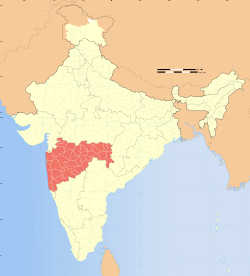
Location of Maharashtra in India
Regions and Divisions
Maharashtra is divided into 36 districts, which are grouped into six divisions. (In the following map, the recently created Palghar district has not been shown)[1]
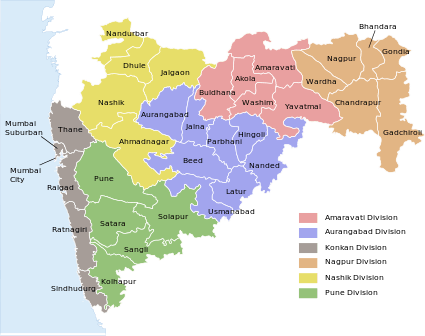
Districts and divisions of Maharashtra (without Palghar district)
Regions
Geographically, historically, politically, and according to cultural sentiments, Maharashtra has five main regions:
- Konkan - (Konkan Division)
- Paschim Maharashtra better known as Desh - (Pune Division)
- Khandesh - (Nashik Division)[lower-alpha 1]
- Marathwada - (Aurangabad Division)
- Vidarbha - (Nagpur and Amravati divisions) - formerly part of (Central Provinces and Berar)[lower-alpha 2]
Divisions
| Name of Division (Headquarter) | Region | Districts | Largest City |
|---|---|---|---|
| Amravati Division (HQ: Amravati) | Vidarbha (Varhad) |
|
Amravati |
| Aurangabad Division (HQ: Aurangabad) | Marathwada |
|
Aurangabad |
| Konkan Division (HQ: Mumbai) | Konkan |
|
Mumbai |
| Nagpur Division (HQ: Nagpur) | Vidarbha |
|
Nagpur |
| Nashik Division (HQ: Nashik) | Khandesh |
|
Nashik |
| Pune Division (HQ: Pune) | Paschim Maharashtra |
|
Pune |
- Nashik district culturally does not belong to Khandesh region. Culturally, Nashik, Ahmednagar and Aurangabad districts share a same pattern which was called Gangathadi.
- Amravati Division used to be a separate region of Central Provinces and Berar as Berar Division known as "Varhad" in Marathi before becoming part of Vidharbha Division of Maharashtra.
Districts
The table below lists important geographic and demographic parameters for all 36 districts. Population data are extracted from the 2001 Census of India.
| No | Name | Code | Formed | Headquarters | Administrative Division | Area (km2) | Population (2011 Census) | Population (2001 census) | % of State Population | Density (per km2) | Urban (%) | Literacy (%) | Sex ratio | Tehsils | Source |
|---|---|---|---|---|---|---|---|---|---|---|---|---|---|---|---|
| 1 | Ahmednagar | AH | 1 May 1960 | Ahmednagar | Nashik | 17,413 | 4,088,077 | 4.22% | 234.77 | 19.67 | 80.22 | 941 | 14 | District website | |
| 2 | Akola | AK | 1 May 1960 | Akola | Amravati | 5,417 | 1,818,617 | 1.68% | 300.78 | 44.04 | 88.05 | 938 | 7 | District website | |
| 3 | Amravati | AM | 1 May 1960 | Amravati | Amravati | 12,626 | 2,606,063 | 2.69% | 206.40 | 34.50 | 82.5 | 838 | 14 | District website | |
| 4 | Aurangabad | AU | 1 May 1960 | Aurangabad | Aurangabad | 10,100 | 2,897,013 | 2.99% | 286.83 | 37.53 | 61.15 | 924 | 9 | District website | |
| 5 | Beed | BI | 1 May 1960 | Beed | Aurangabad | 10,439 | 2,161,250 | 2.23% | 207.04 | 17.91 | 68 | 936 | 11 | District website | |
| 6 | Bhandara | BH | 1 May 1960 | Bhandara | Nagpur | 3,717 | 1,135,835 | 1.17% | 305.58 | 15.44 | 68.28 | 982 | 7 | District website | |
| 7 | Buldhana | BU | 1 May 1960 | Buldhana | Amravati | 9,680 | 2,486,258 | 2,232,480 | 2.3% | 230.63 | 21.2 | 75.8 | 946 | 13 | District website |
| 8 | Chandrapur | CH | 1 May 1960 | Chandrapur | Nagpur | 10,695 | 2,071,101 | 2.14% | 193.65 | 32.11 | 73.03 | 948 | 15 | District website | |
| 9 | Dhule | DH | 1 May 1960 | Dhule | Nashik | 8,063 | 1,707,947 | 1.76% | 211.83 | 26.11 | 71.6 | 944 | 4 | District website | |
| 10 | Gadchiroli | GA | 26 August 1982 | Gadchiroli | Nagpur | 14,412 | 970,294 | 1% | 67.33 | 6.93 | 60.1 | 976 | 12 | District website | |
| 11 | Gondia | GO | 1 May 1999 | Gondia | Nagpur | 4,843 | 1,200,151 | 1.24% | 247.81 | 11.95 | 67.67 | 1005 | 8 | District website | |
| 12 | Hingoli | HI | 1 May 1999 | Hingoli | Aurangabad | 4,526 | 987,160 | 1.02% | 218.11 | 15.2 | 66.86 | 953 | 5 | District website | |
| 13 | Jalgaon | JG | 1 May 1960 | Jalgaon | Nashik | 11,765 | 3,679,936 | 3.8% | 312.79 | 71.4 | 76.06 | 932 | 15 | District website | |
| 14 | Jalna | JN | 1 May 1981 | Jalna | Aurangabad | 7,612 | 1,612,357 | 1.66% | 211.82 | 19.09 | 64.52 | 952 | 8 | District website | |
| 15 | Kolhapur | KO | 1 May 1960 | Kolhapur | Pune | 7,685 | 3,515,413 | 3.63% | 457.44 | 29.65 | 77.23 | 949 | 12 | District website | |
| 16 | Latur | LA | 16 August 1982 | Latur | Aurangabad Division | 7,372 | 2,080,285 | 2.15% | 282.19 | 23.57 | 71.54 | 935 | 10 | District website | |
| 17 | Mumbai City | MC | 1 May 1960 | Mumbai | Konkan | 157 | 3,326,837 | 3.43% | 49,140.9 | 100 | 86.4 | 777 | 0 | District website | |
| 18 | Mumbai Suburban | MU | 1 October 1990 | Bandra | Konkan | 446 | 8,587,000 | 8.86% | 23,271 | 100 | 86.9 | 822 | 3 | District website | |
| 19 | Nagpur | NG | 1 May 1960 | Nagpur | Nagpur | 9,897 | 4,051,444 | 4.18% | 409.36 | 64.33 | 84.18 | 933 | 14 | District website | |
| 20 | Nanded | ND | 1 May 1960 | Nanded | Aurangabad | 10,422 | 2,876,259 | 2.97% | 275.98 | 28.29 | 68.52 | 942 | 16 | District website | |
| 21 | Nandurbar | NB | 1 July 1998 | Nandurbar | Nashik | 5,035 | 1,309,135 | 1.35% | 260 | 15.5 | 46.63 | 975 | 6 | District website | |
| 22 | Nashik | NS | 1 May 1960 | Nashik | Nashik | 15,530 | 4,993,796 | 5.15% | 321.56 | 38.8 | 74.4 | 927 | 15 | District website | |
| 23 | Osmanabad | OS | 1 May 1960 | Osmanabad | Aurangabad | 7,512 | 1,486,586 | 1.53% | 197.89 | 15.7 | 54.27 | 932 | 8 | District website | |
| 24 | Palghar | PL | 1 August 2014 | Palghar | Konkan | 5,344 | 2,990,116 (2011) | 3.09% (2011) | 562 | 50 | 80 | 900 | 8 | District website | |
| 25 | Parbhani | PA | 1 May 1960 | Parbhani | Aurangabad | 6,251 | 1,527,715 | 1.58% | 244.4 | 31.8 | 55.15 | 958 | 9 | District website | |
| 26 | Pune | PU | 1 May 1960 | Pune | Pune | 15,642 | 7,224,224 | 7.46% | 461.85 | 58.1 | 80.78 | 919 | 14 | District website | |
| 27 | Raigad | RG | 1 May 1960 | Alibag | Konkan | 7,148 | 2,207,929 | 2.28% | 308.89 | 24.2 | 77 | 976 | 15 | District website | |
| 28 | Ratnagiri | RT | 1 May 1960 | Ratnagiri | Konkan | 8,208 | 1,696,777 | 1.75% | 206.72 | 11.3 | 65.13 | 1,136 | 9 | District website | |
| 29 | Sangli | SN | 1 May 1960 | Sangli | Pune | 8,578 | 2,583,524 | 2.67% | 301.18 | 24.5 | 62.41 | 957 | 10 | District website | |
| 30 | Satara | ST | 1 May 1960 | Satara | Pune | 10,484 | 2,796,906 | 2.89% | 266.77 | 14.2 | 78.52 | 995 | 11 | District website | |
| 31 | Sindhudurg | SI | 1 May 1981 | Oros | Konkan | 5,207 | 868,825 | 0.9% | 166.86 | 9.5 | 80.3 | 1,079 | 8 | District website | |
| 32 | Solapur | SO | 1 May 1960 | Solapur | Pune | 14,845 | 3,849,543 | 3.97% | 259.32 | 31.8 | 71.2 | 935 | 11 | District website | |
| 33 | Thane | TH | 1 May 1960 | Thane | Konkan | 9,558 | 8,131,849 | 8.39% | 850.71 | 72.58 | 80.67 | 858 | 7 | District website | |
| 34 | Wardha | WR | 1 May 1960 | Wardha | Nagpur | 6,310 | 1,230,640 | 1.27% | 195.03 | 25.17 | 80.5 | 936 | 8 | District website | |
| 35 | Washim | WS | 1 July 1998 | Washim | Amravati | 5,150 | 1,020,216 | 1.05% | 275.98 | 17.49 | 74.02 | 939 | 6 | District website | |
| 36 | Yavatmal | YTL | 1 May 1960 | Yavatmal | Amravati | 13,584 | 2,077,144 | 2.14% | 152.93 | 18.6 | 57.96 | 951 | 16 | District website | |
| Maharashtra | - | - | - | - | - | 307,713 | 96,878,627 | - | 314.42 | 42.43 | 77.27 | 922 | - | - |
See also
- Tehsils in Maharashtra
- Maharashtra
References
- gddrrrtgyyydaweeeList of districts and divisions
| Topics | |||||||||||||
|---|---|---|---|---|---|---|---|---|---|---|---|---|---|
| Regions | |||||||||||||
| Divisions and Districts |
| ||||||||||||
| Million-plus cities in Maharashtra | |||||||||||||
| Other cities with municipal corporations | |||||||||||||
Portal:India | |||||||||||||
| States | ||
|---|---|---|
| Union territories | ||
| Related topics |
| |
This article is issued from Wikipedia. The text is licensed under Creative Commons - Attribution - Sharealike. Additional terms may apply for the media files.