Aurangabad
Aurangabad (![]()
Aurangabad | |
|---|---|
Metropolis | |
Clockwise from top left: Grishneshwar, Ajanta Caves, Daulatabad Fort, Bibi Ka Maqbara, Aurangabad Caves | |
| Nickname(s): | |
 Aurangabad  Aurangabad  Aurangabad | |
| Coordinates: 19.88°N 75.32°E | |
| Country | India |
| State | Maharashtra |
| Region | Marathwada |
| Division | Aurangabad |
| District | Aurangabad |
| Established | A.D. 1610 |
| Founded by | Malik Ambar |
| Government | |
| • Divisional Commissioner of Aurangabad | Purushottam Bhapkar |
| • Police Commissioner of Aurangabad | Chiranjeev Prasad (IPS) |
| • MP | Imtiyaz Jaleel (AIMIM) |
| • Mayor | Nandkumar Ghodele |
| • MLAs |
|
| Area | |
| • Metropolis | 139 km2 (54 sq mi) |
| Elevation | 568 m (1,864 ft) |
| Population (2011)[1] | |
| • Metropolis | 1,175,116 |
| • Rank | India: 32nd Maharashtra: 6th Marathwada: 1st |
| • Density | 8,500/km2 (22,000/sq mi) |
| • Metro | 1,593,167 |
| Demonym(s) | Aurangabadi |
| Time zone | UTC+5:30 (IST) |
| PIN | 431 XXX |
| Telephone code 0240 | 0240 |
| Vehicle registration | MH 20 |
| Official Language | Marathi,Urdu & Hindi [3] |
.jpg)
.JPG)
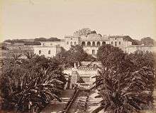
Paithan, the imperial capital of the Satavahana dynasty (1st century BCE–2nd century CE), as well as Daulatabad or Dēvagirī, the capital of the Yadava dynasty (9th century CE–14th century CE), are located within the limits of modern Aurangabad. In 1308, the region was annexed by the Delhi Sultanate during the rule of Sultan Alauddin Khalji. In 1327, the capital of the Delhi Sultanate was shifted from Delhi to Daulatabad (in present-day Aurangabad) during the rule of Sultan Muhammad bin Tughluq, who ordered a mass migration of Delhi's population to Daulatabad. However, Muhammad bin Tughluq reversed his decision in 1334 and the capital was shifted back to Delhi. In 1499, Daulatabad became a part of the Ahmadnagar Sultanate. In 1610, a new city named Khaḍkī was established at the location of modern Aurangabad to serve as the capital of the Ahmadnagar Sultanate by the Ethiopian military leader Malik Ambar, who was brought to India as a slave but rose to become a popular Prime Minister of the Ahmadnagar Sultanate. Malik Ambar was succeeded by his son Fateh Khan, who changed the name of the city to Fatehnagar. In 1636, Aurangzeb, who was then the Mughal viceroy of the Deccan region, annexed the city into the Mughal Empire. In 1653, Aurangzeb renamed the city as "Aurangabad" and made it the capital of the Deccan region of the Mughal Empire. In 1724, the Mughal governor of the Deccan, Nizam Asaf Jah I, seceded from the Mughal Empire and founded his own Asaf Jahi dynasty. The dynasty established the State of Hyderabad with their capital initially at Aurangabad, until they transferred their capital to the city of Hyderabad in 1763. Hyderabad State became a princely state during the British Raj, and remained so for 150 years (1798–1948). Until 1956, Aurangabad remained part of Hyderabad State. In 1960, Aurangabad and the larger Marathi-speaking Marathwada region became a part of the state of Maharashtra.
History
Khaḍkī was the original name of the village which was made a capital city by Malik Ambar, the Prime Minister of Murtaza Nizam Shah II, Sultan of Ahmednagar. Within a decade, Khaḍkī grew into a populous and imposing city. Malik Ambar died in 1626.[8] He was succeeded by his son Fateh Khan, who changed the name of Khaḍkī to Fatehnagar. With the capture of Daulatabad Fort by the imperial troops in 1633, the Nizam Shahi dominions, including Fatehnagar, came under the possession of the Mughals.[9]
In 1653 when Mughal prince Aurangzeb was appointed the Viceroy of the Deccan for the second time, he made Fatehnagar his capital and renamed it Aurangabad. Aurangabad is sometimes referred to as Khujista Bunyad by the Chroniclers of Aurangzeb's reign.
In 1724, Asaf Jah, a Turkic general and Nizam al-Mulk of the Mughals in the Deccan region, decided to secede from the crumbling Mughal Empire, with the intention of founding his own dynasty in the Deccan and decided to make Aurangabad his capital. His son and successor, Nizam Ali Khan Asaf Jah II transferred his capital from Aurangabad to Hyderabad in 1763.[10] In 1795, the city came under the Maratha rule, following the Maratha victory in the Battle of Kharda,[11] along with an indemnity of 30 million rupees paid by Ali Khan Asaf Jah II, Nizam of Hyderabad to the Marathas. However, Maratha rule lasted only eight years before the city came under the rule of the Nizam of Hyderabad, under the protection of the British East India Company, following the British victory in the Second Anglo-Maratha War. During the period of the British Raj, the city was known as Aurungábád.[12]
Aurangabad was a part of the Princely State of Hyderabad during the British Raj, until its annexation into the Indian Union after the Indian Independence in 1947, and thereafter a part of Hyderabad state of India until 1956. In 1956 it became a part of newly formed bilingual Bombay State and in 1960 it became a part of Maharashtra state.[13]
Climate
| Climate data for Aurangabad (Aurangabad Airport) 1981–2010, extremes 1952–2012 | |||||||||||||
|---|---|---|---|---|---|---|---|---|---|---|---|---|---|
| Month | Jan | Feb | Mar | Apr | May | Jun | Jul | Aug | Sep | Oct | Nov | Dec | Year |
| Record high °C (°F) | 34.2 (93.6) |
37.8 (100.0) |
40.6 (105.1) |
43.6 (110.5) |
43.6 (110.5) |
43.0 (109.4) |
37.1 (98.8) |
35.6 (96.1) |
37.0 (98.6) |
37.6 (99.7) |
34.6 (94.3) |
33.6 (92.5) |
43.6 (110.5) |
| Average high °C (°F) | 29.2 (84.6) |
31.8 (89.2) |
35.7 (96.3) |
38.6 (101.5) |
39.4 (102.9) |
34.7 (94.5) |
30.2 (86.4) |
29.0 (84.2) |
30.4 (86.7) |
31.6 (88.9) |
30.2 (86.4) |
28.7 (83.7) |
32.5 (90.5) |
| Average low °C (°F) | 12.2 (54.0) |
14.2 (57.6) |
18.5 (65.3) |
22.4 (72.3) |
24.4 (75.9) |
23.4 (74.1) |
22.2 (72.0) |
21.5 (70.7) |
21.2 (70.2) |
18.5 (65.3) |
14.7 (58.5) |
11.8 (53.2) |
18.8 (65.8) |
| Record low °C (°F) | 1.2 (34.2) |
1.9 (35.4) |
7.1 (44.8) |
10.2 (50.4) |
14.2 (57.6) |
18.5 (65.3) |
18.4 (65.1) |
17.2 (63.0) |
12.6 (54.7) |
8.3 (46.9) |
1.9 (35.4) |
1.2 (34.2) |
1.2 (34.2) |
| Average rainfall mm (inches) | 3.3 (0.13) |
2.2 (0.09) |
6.0 (0.24) |
3.9 (0.15) |
19.5 (0.77) |
137.4 (5.41) |
164.8 (6.49) |
170.7 (6.72) |
175.8 (6.92) |
76.8 (3.02) |
19.2 (0.76) |
10.1 (0.40) |
789.7 (31.09) |
| Average rainy days | 0.3 | 0.3 | 0.5 | 0.3 | 1.7 | 7.4 | 10.8 | 10.3 | 8.7 | 4.0 | 1.2 | 0.7 | 46.2 |
| Average relative humidity (%) (at 17:30 IST) | 37 | 31 | 26 | 25 | 28 | 54 | 70 | 73 | 66 | 48 | 44 | 41 | 45 |
| Source: India Meteorological Department[14][15] | |||||||||||||
The co-ordinates for Aurangabad are N 19° 53' 47" – E 75° 23' 54". The city is surrounded by hills on all directions.
Aurangabad features a semiarid climate under the Köppen climate classification.
Annual mean temperatures range from 17 to 33°C, with the most comfortable time to visit in the winter – October to February. The highest maximum temperature ever recorded was 46°C (114°F) on 25 May 1905. The lowest recorded temperature was 2°C (36°F) on 2 February 1911. In the cold season, the district is sometimes affected by cold waves in association with the eastward passage of western disturbances across north India, when the minimum temperature may drop down to about 2°C to 4°C (35.6°F to 39.2°F).[16]
Most of the rainfall occurs in the monsoon season from June to September. Thunderstorms occur between November to April. Average annual rainfall is 710 mm. The city is often cloudy during the monsoon season and the cloud cover may remain together for days. The daily maximum temperature in the city often drops to around 22 °C due to the cloud cover and heavy rains.[17]
Geology
The entire area is covered by the Deccan Traps lava flows of Upper Cretaceous to Lower Eocene age. The lava flows are overlain by thin alluvial deposits along the Kham and Sukhana river. The basaltic lava flows belonging to the Deccan Trap is the only major geological formation occurring in Aurangabad. The lava flows are horizontal and each flow has two distinct units. The upper layers consist of vesiculara and amygdaloidal zeolitic basalt while the bottom layer consists of massive basalt. The lava flows are individually different in their ability to receive as well as hold water in storage and to transmit it. The difference in the productivity of groundwater in various flows arises as a result of their inherent physical properties such as porosity and permeability. The groundwater occurs under water table conditions and is mainly controlled by the extent of its secondary porosity i.e. thickness of weathered rocks and spacing of joints and fractures. The highly weathered vesicular trap and underlying weathered jointed and fractured massive trap constitutes the main water-yielding zones. The soil is mostly formed from igneous rocks and is black, medium black, shallow and calcareous types having different depths and profiles.[18]
Demographics
| Population growth | |||
|---|---|---|---|
| Census | Population | %± | |
| 1901 | 10,000 | — | |
| 1911 | 34,902 | 249.0% | |
| 1921 | 36,876 | 5.7% | |
| 1931 | 36,870 | 0.0% | |
| 1941 | 50,924 | 38.1% | |
| 1951 | 66,636 | 30.9% | |
| 1961 | 97,701 | 46.6% | |
| 1971 | 165,253 | 69.1% | |
| 1981 | 301,000 | 82.1% | |
| 1991 | 592,000 | 96.7% | |
| 2001 | 902,179 | 52.4% | |
| 2011 | 1,421,879 | 57.6% | |
| Source:Census of India[2][19] | |||
According to the 2011 Indian Census, Aurangabad has a population of 1,175,116, of which 609,206 are males and 565,910 are females. Population in the age range of 0 to 6 years is 158,779. The total number of literates in Aurangabad was 889,224, which constituted 75.67% of the population with male literacy of 79.34% and female literacy of 71.72%. The effective literacy rate of 7+ population of Aurangabad was 87.5%, of which male literacy rate was 92.2% and female literacy rate was 82.5%. The Scheduled Castes and Scheduled Tribes population is 229,223 and 15,240 respectively. There were 236659 households in Aurangabad in 2011.[1]
Language
Marathi is the official language of the city.[3] Marathi is also the most commonly spoken language in the city, followed by Hindi.[20]
Economy
Industry
Aurangabad is considered to be a classic example of efforts of state government towards balanced industrialisation of state.[22] The city was a major silk and cotton textile production center. A fine blend of silk with locally grown cotton was developed as Himroo textile. Paithani silk saris are also made in Aurangabad. With the opening of the Hyderabad-Godavari Valley Railways in the year 1900 several ginning factories were started.[23] After 1960, Maharashtra Industrial Development Corporation (MIDC) began acquiring land and setting up industrial estates. The Maharashtra Center For Entrepreneurship Development's main office is in Aurangabad.[24]
Aurangabad is surrounded by the industrial areas (MIDCs) of Chikhalthana, Shendra and Waluj MIDC. A new industrial belt namely Shendra - Bidkin Industrial Park is being developed under DMIC.[25]
Administration and politics
Local administration
Aurangabad Municipal Corporation (AMC) is the local civic body. It is divided into six zones. The Municipal Council was established in 1936, the Municipal Council area was about 54.5 km2. It was elevated to the status of Municipal Corporation from 8 December 1982, and simultaneously including eighteen peripheral villages, making the total area under its jurisdiction to 138.5 km2 extended its limits.
The city is divided in 115 electoral wards called as Prabhag, and each ward is represented by a Corporator elected by the people from each ward. There are two Committees, General Body and Standing Committee headed by the Mayor and the chairman respectively. AMC is responsible for providing basic amenities like drinking water, drainage facility, road, street lights, healthcare facilities, primary schools, etc. AMC collects its revenue from the urban taxes which are imposed on citizens. The administration is headed by the Municipal Commissioner; an IAS Officer, assisted by the other officers of different departments.
State and central administration
Aurangabad division is one of the six administrative divisions of Maharashtra state in India. Aurangabad divisions almost completely coincides with the Marathwada region of Maharashtra.Aurangabad contributes one seat to the Lok Sabha – Aurangabad (Lok Sabha constituency). In 2019 general election, AIMIM candidate Sayed Imtiyaz Jaleel was elected as a member of parliament from Aurangabad.[26]
Aurangabad will also contribute three state assembly seats namely Aurangabad East, Aurangabad West and Aurangabad Central. The latest MLAs being – Aurangabad (East) – Atul Moreshwar Save(BJP), Aurangabad (Central) – Imtiyaz Jaleel (AIMIM) and Aurangabad (West) Sanjay Shirsat of Shiv-Sena.[27][28]
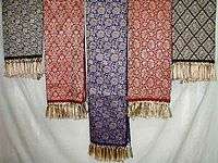 Himroo Shawl
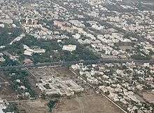 Bombay High Court Aurangabad Bench, ITC Welcomgroup's The Rama International, Ajanta Ambassador & Cidco Town Center – Aerial view
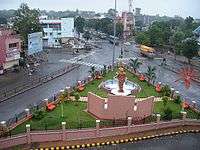
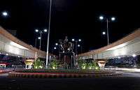 Kranti Chowk
Transport
Air
Aurangabad Airport is an airport serving the city and has connecting flights to Hyderabad, Delhi, Mumbai, Bangalore, Ahmedabad, Udaipur, Tirupati, Visakhapatnam and Thiruvananthapuram. In 2008, flights were made available to the people travelling to the Hajj pilgrimage.[29][30]
Rail
Aurangabad railway station is the major railway station under Nanded railway division of the South Central Railway zone. It is located on the Secunderabad-Manmad section and has rail connectivity with major cities such as Hyderabad, Delhi, Nizamabad, Nagpur, Nashik, Pune, Nanded and Latur Road.
Road
Central Bus Stand, Aurangabad of MSRTC is the main public transport centre. Buses are available to every major bus depots of Maharashtra. Ola Cabs service is available in city. Major long route Aurangabad buses reach Delhi, Jaipur, Gandhinagar and Hyderabad in 2–3 days.
 Aurangabad Airport
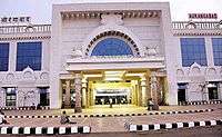 Aurangabad Railway Station
Education
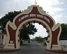
Dr. Babasaheb Ambedkar Marathwada University (BAMU) is located in Aurangabad city. Many colleges in the region are affiliated to it. The University has 101 Colleges affiliated in Aurangabad and 99 Colleges in Beed, 53 & 55 Colleges affiliated in Jalna & Osmanabad.[31]
Government College of Engineering, Aurangabad is an autonomous engineering college. It was affiliated to the Dr. Babasaheb Ambedkar Marathwada University and was established in 1960. The construction of the college was started in 1957 and was completed in 1960. Marathwada Institute of Technology and Jawaharlal Nehru Engineering College are two other engineering colleges in Aurangabad.
Maharashtra National Law University, Aurangabad is a state university[32] located in Aurangabad. It was established in 2017 by the Government of Maharashtra, the third and final university to be installed through the Maharashtra National Law University Act, 2014[33]
Maulana Azad College of Arts and Science was founded in 1963 by Rafiq Zakaria, who formed a trust called Maulana Azad Education Society to manage the affairs. The College is affiliated to Dr. Babasaheb Ambedkar Marathwada University of Aurangabad.
National Institute of Electronics & Information Technology Aurangabad (NIELIT Aurangabad) is located inside the Dr. B.A.M. university campus. It is a central government engineering institute under the Ministry of Communication & Information Technology Government of India. It offers DEPM, B.TECH (Electronics Engineering), M.tech (Electronics Design Technology), Ph.D, and short-term courses.
Aurangabad has schools run by the Aurangabad Municipal Corporation (AMC) and private schools owned and run by trusts and individuals. Government Polytechnic Aurangabad is one of the polytechnic institutions in Marathwada region.
Institute of Hotel Management, Aurangabad, is affiliated to University of Huddersfield. Students have internships in the Vivanta, Taj in Aurangabad.[34]
In 1903, a treaty was signed between British and the Nizam to train the Nizam's Army and it was decided to establish a proper cantonment. Today the cantonment is spread across 2,584 acres (10.46 km2) with civil population of 19,274 as per 2001 census.[35]
Tourist attractions
Aurangabad is a historical city along with its surrounding towns and villages.[36]
Indian religions
Indian rock-cut architecture
- Ajanta Caves, Aurangabad Caves and Ellora Caves
.jpg) The Ajanta Caves are 30 rock-cut Buddhist cave monument built under the Vakatakas.
The Ajanta Caves are 30 rock-cut Buddhist cave monument built under the Vakatakas. Buddhist "Chaitya Griha" or prayer hall, with a seated Buddha, Cave 26 of the Ajanta Caves.
 Various sculptors next to an entrance at Aurangabad Caves.
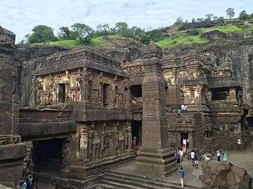 Central pillar near Kailasa temple at Ellora Caves.
 Statue of the Buddha seated. A part of the Carpenter's cave (Buddhist Cave 10).
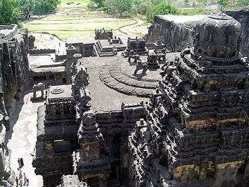 Kailasa temple, Ellora, Aurangabad
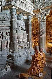 Buddhist monks praying in front of the Dagoba of Chaitya Cave 26 of the Ajanta Caves.
- Ajanta Caves and Ellora: The Ellora and Ajanta Caves are situated at 29 km (18 mi) and 107 km (66 mi) respectively from Aurangabad city and come within the Aurangabad district. The Ellora Caves consist of 34 caves built between 5th and 10th century CE under the patronage of Rashtrakuta Dynasty. They represent the epitome of Indian rock cut architecture.[37] The Ajanta Caves are also 30 rock cut caves around a gorge, built by the Satavahana, Vakataka and Chalukya dynasties between 2nd and 5th century CE.[38] They contain the rarest and finest surviving examples of ancient Indian art, especially painting.[39] Both the Ellora and Ajanta Caves are UNESCO World Heritage Sites.
- Aurangabad Caves: These are situated at a distance of 5 km (3 mi), nestled amidst the hills are 12 Buddhist caves dating back to 3 A.D. Of particular interest are the Tantric influences evident in the iconography and architectural designs of the caves.
Hindu and Jain temples
 View of Grishneshwar temple
 Idol of Lord Shri Parshvanath at Kachner temple
- Grishneshwar Temple: It is one of the 12 Jyotirlinga shrines in India. The present temple was built by Ahilyabhai Holkar in the 18th century CE. The structure is a unique example of Bhoomija architecture with a Maratha style influence.[40]
- Kachner Jain Temple: This is a 250 years old temple dedicated to Parshvanath. The idol here is called Chintamani Parshvanath.
- Shuli bhanjan: It is believed that Saint Eknath Maharaj carried his tapasya at this place.
Gates and Forts
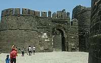 Front view of Daulatabad Fort
 Bhadkal Gate, part of Gates in Aurangabad.
- Daulatabad Fort: The Daulatabad Fort (aka Devagiri Fort), located about 15 km (9 mi) north-west of Aurangabad was one of the most powerful forts during the medieval period. Built in the 12th century CE by the Yadava Dynasty, it's a citadel that was never conquered by any military force. Built on a 200-metre-high (660 ft) conical hill, the fort was defended by moats and trenches running around the hill at its foot besides the most complex and intricate defence system. The fort has two fixed massive canons which can be pivoted. The fortifications comprise three encircling walls with bastions.[41]
- Gate: The city is also known for the 52 gates built during Mughal era which gives it the name of "City of Gates".[42]
Mughal architecture
_2.jpg)
- Bibi Ka Maqbara: The Aurangabad city is known for the Bibi Ka Maqbara situated about 3 km (2 mi) from the city which is the burial mausoleum of Emperor Aurangzeb's wife, Dilras Banu Begum also known as Rabia-ud-Daurani. It is an imitation of the Taj Mahal at Agra and due to its similar design, it is popularly known as the "Taj of the Deccan".[43]
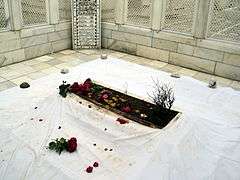
- Tomb of Aurangzeb: The tomb of the last great[44] Mughal emperor Aurangzeb is located in the village of Khuldabad, 24 km (15 mi) to the north-west of Aurangabad in Aurangabad district[45] It is located in the south-eastern corner of the complex of the dargah of Sheikh Zainuddin.[45]
Other
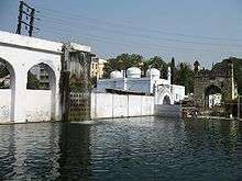 Panchakki, was designed to generate energy via water brought down from a spring on a mountain. It displays the scientific thought process put in medieval Indian architecture.
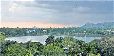
 Siddharth Garden near bus stand Aurangabad
- Panchakki: Panchakki, which literally means water mill, is a 17th-century watermill situated within the old city is known for its underground water channel, which traverses more than 8 km from nearby hills. The channel culminates into an artificial waterfall that powers the mill.
- Salim Ali Lake & Bird Sanctuary: Popularly known as Salim Ali Talab (lake) is located in the northern part of the city near Delhi Darwaza, opposite Himayat Bagh. During the Mughal period, it was known as Khiziri Talab. It has been renamed after the great ornithologist and naturalist Salim Ali. It also has a bird Sanctuary and a garden maintained by the Aurangabad Municipal Corporation.
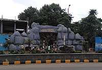
- Siddharth Garden and Zoo: is a park and zoo situated in near of the central bus station in Aurangabad. This is the only zoo in Marathwada region. There are various types of animals, birds, flowers and trees. The name of "Siddhartha" has been kept on the name of Gautama Buddha.[46][47][48]
Culture
The culture of Aurangabad city is heavily influenced by the culture of Hyderabad. The old city still retains the cultural flavour and charms of Muslim culture of Hyderabad. Its influence is reflected in the language and cuisine of the locals. Although Marathi and Urdu are the principal languages of the city, they are spoken in Dakhni – Hyderabadi Urdu dialect.[49]
- Wali Dakhni also known as Wali Aurangabadi (1667–1731 or 1743) was a classical poet of Urdu from Aurangabad. He was the first established poet to have composed in Urdu language. Prominent poets like Shah Hatem, Shah Abro, Mir Taqi Mir, Zauq and Sauda were among his admirers.[49] Other prominent poets from Aurangabad include Siraj Aurangabadi, Azad Bilgrami and Sikandar Ali Wajd.
- Abul Ala Maududi one of the Muslim scholars (1903–1979) was born in Aurangabad, India. Syed Abul A'ala Maududi was born to Maulana Ahmad Hasan, a lawyer by profession.[50] His father was "descended from the Chishti line of saints.[51] He was also the founder of Jamaat-e-Islami, the Islamic revivalist party.[52]
Mashru and Himroo
- Himroo: The fabric is said to have originated in Persia, though not conclusively proved, Himroo is associated with the times of Mohammad Tughlaq who ruled in the 14th century. Fabrics and shawls from Aurangabad are much in demand for their unique style and design.[53]
- Kaghzipura: A place situated near Daulatabad made first handmade paper in India after the technology was brought here by Mongol invaders. However, the use of paper was not widespread there until the 12th century.
Cuisine
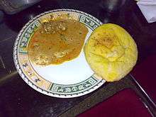
Aurangabadi food is much like Mughlai or Hyderabadi cuisine with its fragrant pulao and biryani. Meat cooked in fresh spices and herbs is a speciality, as are the delectable sweets. The local cuisine is a blend of Mughlai and Hyderabadi cuisine, with an influence of the spices and herbs of the Marathwada region.[54]
- Naan Qalia is a dish that is associated with Aurangabad in India. It is a concoction of mutton and a variety of spices. Naan is the bread made in tandoor (Hot furnace) while Qalia is a mixture of mutton and various spices.
- Aurangabad/Marathwada/Dakhni cuisine is a blend of the Puneri and the Hyderabadi cuisine (which blends the use of typical South Indian ingredients such as curry leaves, tamarind and coconut into their celebrated culinary practices).[55]
Sports
Garware Stadium is the municipal stadium in the city.[56] International-standard cricket stadium at Aurangabad District Cricket Association Stadium is under construction. Jawaharlal Nehru Engineering College Sports Complex is a sports complex with in Jawaharlal Nehru Engineering College mainly used by college sports event.
Notable people
- Ankit Bawne, cricketer
- Tarang Jain, businessman
- Imtiyaz Jaleel, Indian politician and member of the All India Majlis-e-Ittehadul Muslimeen
- Mayuri Kango, film actress
- Chandrakant Khaire, Indian politician and member of Shiv Sena
- Abul A'la Maududi, Pakistani theologian and philosopher of Islam
- Bashar Nawaz, Urdu Poet
- Dulari Qureshi, art historian
- Iqbal Siddiqui, cricketer
- Vineet Verma, film director
- Rafiq Zakaria, Indian politician
See also
References
- "Census of India: Aurangabad". censusindia.gov.in. Retrieved 1 October 2019.
- "Census of India : Provisional Population Totals Paper 2 of 2011 : India (Vol II)". Archived from the original on 1 November 2011. Retrieved 29 October 2011.
- "52nd REPORT OF THE COMMISSIONER FOR LINGUISTIC MINORITIES IN INDIA" (PDF). nclm.nic.in. Ministry of Minority Affairs. p. 108. Archived from the original (PDF) on 25 May 2017. Retrieved 14 January 2019.
- Sohoni, Pushkar (2015). Aurangabad with Daulatabad, Khuldabad and Ahmadnagar. Mumbai: Jaico. ISBN 9788184957020.
- Gopal, Madan (1990). K.S. Gautam (ed.). India through the ages. Publication Division, Ministry of Information and Broadcasting, Government of India. p. 174.
- "India's first industrial integrated smart city set for inauguration". The Times of India. 6 September 2019. Retrieved 6 September 2019.
- "PM Modi opens first greenfield industrial smart city in Aurangabad". India Today. 7 September 2019. Retrieved 7 September 2019.
- Qureshi Dulari, "Tourism Potential in Aurangabad," p.6
- Sohoni, Pushkar (2015). Aurangabad with Daulatabad, Khuldabad, and Ahmadnagar. Aurangabad: Deccan Heritage Foundation; Jaico. ISBN 9788184957020.
- Govt of Maharashtra – Aurangabad Gazetteer Archived 9 August 2011 at the Wayback Machine
- "Hyderabad Rulers with their Coinage details". Chiefacoins.com. Archived from the original on 15 June 2012. Retrieved 27 February 2014.
- "

- Green, Nile (2004). "Stories of saints and sultans remembering history at the Sufi shrines of Aurangabad" (PDF). Archived from the original (PDF) on 17 September 2016. Retrieved 7 September 2016.
- "Station: Aurangabad (Chikalthana)(A) Climatological Table 1981–2010" (PDF). Climatological Normals 1981–2010. India Meteorological Department. January 2015. pp. 55–56. Archived from the original (PDF) on 5 February 2020. Retrieved 3 April 2020.
- "Extremes of Temperature & Rainfall for Indian Stations (Up to 2012)" (PDF). India Meteorological Department. December 2016. p. M137. Archived from the original (PDF) on 5 February 2020. Retrieved 3 April 2020.
- Maharashtra government web site Archived 9 August 2011 at the Wayback Machine
- "Marathwada – SANDRP". Archived from the original on 14 April 2019. Retrieved 14 April 2019.
- Aher K.R. 'Groundwater Quality studies of Chikalthana area of Aurangabad', PhD Thesis, Dr.B.A.M.University, Aurangabad(Maharashtra State), India,2012 page-38
- [Govt of Maharashtra Aurangabad Gazetteer. Section – The People (population)]
- "C-1 Population By Linguistic Community – Maharashtra". Census. Retrieved 29 December 2019.
- "C-1 Population By Religious Community – Maharahstra". Census. Retrieved 29 December 2019.
- TOI (12 April 2009). "History revisited at Aurangabad". The Times of India. Archived from the original on 6 May 2009. Retrieved 20 January 2010.
- "Hyderabad" by Mirza Mehdy Khan, Imperial Gazetteer of India, Government Printing Press, Calcutta, 1909.
- "Maharashtra Centre For Entrepreneurship Development". mced.in. Retrieved 26 May 2019.
- Ashar, Sandeep (15 October 2011). "Share on emailShare on printShare on redditMore Sharing Services Four mega industrial towns". The Times of India. Bennett, Coleman & Co. Ltd. Archived from the original on 1 May 2013. Retrieved 31 May 2012.
- "AIMIM's Jaleel wins Aurangabad seat, beats Khaire". The Asian Age. 24 May 2019. Retrieved 25 May 2019.
- "Map of Aurangabad Loksabha and Assembly seats" (PDF). Archived from the original (PDF) on 30 September 2011. Retrieved 5 July 2018.
- Election Commission of India Archived 21 May 2009 at the Wayback Machine
- "Direct Haj flights from Aurangabad". Daily News and Analysis. 22 November 2008. Archived from the original on 16 September 2012. Retrieved 14 August 2014.
- "Aurangabad Airport AAI website". Archived from the original on 5 July 2017. Retrieved 5 July 2018.
- "List of Affiliated Colleges and Institutions". Archived from the original on 2 December 2011. Retrieved 13 December 2011.
- "List of State Universities as on 18.09.2017" (PDF). University Grants Commission. 18 September 2017. Retrieved 27 September 2017.
- "Maharashtra National Law University Act, 2014" (PDF). Maharashtra Gazette. Government of Maharashtra. 20 March 2014. Archived from the original (PDF) on 28 September 2017. Retrieved 28 September 2017.
- "National Institute of Electronics and Information Technology, Aurangabad". Aurangabad.nielit.gov.in. Archived from the original on 5 May 2015. Retrieved 29 May 2015.
- "Aurangabad". Aurangabad Cantonment Board. Archived from the original on 25 February 2012. Retrieved 31 May 2012.
- "Tourist Places | District Aurangabad". Archived from the original on 14 April 2019. Retrieved 14 April 2019.
- "Ellora Caves, Maharashtra – Archaeological Survey of India". Archived from the original on 7 October 2015. Retrieved 29 October 2015.
- "Indian Heritage – Ajanta Cave paintings – Period of Excavation, Patronage, Re-discovery". Archived from the original on 28 February 2015. Retrieved 29 October 2015.
- "Archaeological Survey of India". Archived from the original on 9 October 2015. Retrieved 29 October 2015.
- "Archived copy". Archived from the original on 25 December 2015. Retrieved 9 August 2018.CS1 maint: archived copy as title (link)
- "Daulatabad Fort – Ticketed Monument – Archaeological Survey of India". Archived from the original on 29 April 2015. Retrieved 29 October 2015.
- Banerjee, Rajiv (12 April 2009). "History revisited at Aurangabad the 'city of gates'". The Economic Times. Archived from the original on 24 March 2014. Retrieved 27 February 2014.
- P., Bhaskar. "The Taj of Deccan". Deccan Herald. Archived from the original on 3 March 2014. Retrieved 27 February 2014.
- "Archived copy". Archived from the original on 20 July 2018. Retrieved 19 July 2018.CS1 maint: archived copy as title (link)
- "Tomb of Aurangzeb" (PDF). Archaeological Survey of India, Aurangabad. Archived (PDF) from the original on 23 September 2015. Retrieved 29 October 2015.
- "Archived copy". Archived from the original on 12 January 2019. Retrieved 12 January 2019.CS1 maint: archived copy as title (link)
- https://abpmajha.abplive.in/aurangabad/animal-museum-in-siddhartha-garden-of-aurangabad-will-be-closed-609661
- "Siddharth Garden Zoo". Archived from the original on 6 January 2016. Retrieved 29 October 2015.
- "Dakhni – The Language of India's Composite Culture". Archived from the original on 2 October 2011. Retrieved 19 September 2009.
- Sayyid Abul A'la Maududi. Official website of the Jamaat-e-Islami. Archived 15 March 2010 at the Wayback Machine
- Adams, p.100-101
- Archived 20 August 2011 at the Wayback Machine
- Qureshi, Dulari (1 January 1999). Tourism Potential in Aurangabad. Delhi: Bhartiya Kala Prakashan. p. 65. ISBN 978-81-86050-44-6.
- The cuisine of Auguranbad Archived 27 August 2007 at the Wayback Machine
- "Upper Crust ::: India's food, wine and style magazine". Archived from the original on 17 July 2011. Retrieved 15 September 2009.
- "Garware stadium set for a facelift". The Times of India. Retrieved 14 April 2019.
External links
| Wikimedia Commons has media related to Aurangabad. |

- . Encyclopædia Britannica. 2 (11th ed.). 1911. p. 922.
- Aurangabad District website
- Gazetteer of Aurangabad. Bombay: Times of India. 1884.
- Aurangabad Encyclopædia Britannica entry
Places adjacent to Aurangabad | ||||||||||
|---|---|---|---|---|---|---|---|---|---|---|
| ||||||||||
| Districts of Marathwada | |
|---|---|
| Cities with municipal corporations | |
| Topics | |
Portal:India | |

| Topics | |||||||||||||
|---|---|---|---|---|---|---|---|---|---|---|---|---|---|
| Regions | |||||||||||||
| Divisions and Districts |
| ||||||||||||
| Million-plus cities in Maharashtra | |||||||||||||
| Other cities with municipal corporations | |||||||||||||
Portal:India | |||||||||||||