Alibag
Alibag is a coastal town and a municipal council in Raigad District of Maharashtra, India. It is the headquarters of the Raigad district and is south of the city of Mumbai. Alibag is part of Mumbai Metropolitan Region and is situated at a distance of about 96km from Mumbai and 143km from Pune.
Alibag Ramnath | |
|---|---|
Coastal City Mumbai Metropolitan City | |
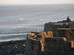 Alibag Fort in Alibag | |
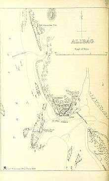
 Alibag Location of Alibag | |
| Coordinates: 18.64°N 72.88°E | |
| Country | India |
| State | Maharashtra |
| District | Raigad |
| Elevation | 0 m (0 ft) |
| Population (2011) | |
| • Total | 20,743 |
| Languages | |
| • Official | Marathi |
| Time zone | UTC+5:30 (IST) |
| Postal Index Number | 402 201 |
| Telephone code | 02141 |
| Climate | Tropical savanna climate |
History
Alibag is a coastal town and municipal council in Raigad district of Maharashtra, India. It is the headquarters of the Raigad district.
Revdanda, Chaul, Nagaon, Akshi, Varsoli, Thal, Navgaon, Kihim, and Aawas villages were known as "Ashtagare".
Alibag and its surrounding villages are the historic hinterlands of Bene Israeli Jews. There is a synagogue in the "Israel Ali" (Marathi इस्राएल आळी meaning Israel lane) area of the town.[1] A Bene Israelite named Ali used to live there at that time. He was a rich man and owned many plantations of mangoes and coconuts in his gardens. Hence the locals used to call the place "Alichi Bagh"(Marathi for "Ali's Garden"), or simply "Alibag", and the name stuck.[1]
Alibag houses a magnetic observatory which was set up in 1904.[2] It serves as one of the significant observatories forming part of a global network now run by Indian Institute of Geomagnetism. The observatory has two buildings; the first building has magnetometers that record changes occurring in the geomagnetic fields. The second building consists of precision recording instruments, which give data about geomagnetic storms caused by solar storms which are shared with other countries.[2]
Geography
Alibag is located about 120 km south of Mumbai, at 18°38′29″N 72°52′20″E. The average elevation is 0 metres (0 feet).The District Government offices are located along the sea coast road. Alibag is the center place of Raigad District.
Transport
Road
One can reach Alibag via Pen (30 km), which is on the Mumbai (78 km) – Goa road. From Mumbai, one can reach Alibag by traveling on the Mumbai-Goa highway (NH-66) till Wadkhal (or Vadkhal) and taking the right fork from Wadkhal to continue on (NH-166A)– the left fork being the road to Goa.[3] It is approximately 108 km from Mumbai. Alibag is 50 km away from Murud. By boat service from Mumbai one can reach Alibag by 1 and half hour's journey. one can reach alibag also with speedboat with a journey of 10-15 minuts from Gateway of India to mandva.
Railways
The nearest rail railway station is at Pen. Through Pen, it is connected to Panvel and onwards to Mumbai and the Indian Railways network. Now pen-panvel trains are also started from 4 November 2018 now it is easier to reach alibag easily.
Boat services
The nearest jetty is Mandwa from where catamaran/ferry services are available to the Gateway of India, Mumbai. Another port in the vicinity is Rewas, from where a ferry service is available to Ferry Wharf (Bhau cha Dhakka) (Dockyard Road). There is a jetty at Custom Bandar from where fishermen in Alibag set sail.
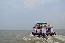
One can reach Alibag by catamaran through Gateway of India to Mandwa or from Bhaucha Dhakka to Rewas and from Mandwa/Rewas to Alibag by bus. Ticket includes journey from Gateway to Mandwa and bus journey from Mandwa to Alibag bus stop. The well known operators of these catamarans are PNP, Maldar and Ajanta and tickets can be purchased at their booth at the Gateway of India. From Rewas to Alibag one needs to take State Transport bus or a rickshaw. Take the ferry from Gateway to Mandwa. Services are usually available from 6:00am till 6:00pm. The trip takes 40 to 55 minutes depending on the type of boat. From Mandwa operators carry passengers to Alibag in their own chartered buses. The bus journey time is 45 minutes. Alibag beach is walking distance from the bus-stop.
Another option is to take a ferry from "Bhaucha Dhakka" to Rewas. Timings are the same but schedule may change depending on the tide. From Rewas take state transport bus or rickshaw to Alibag.
Speedboats from the Gateway of India to Mandwa Jetty take roughly 20–25 minutes depending on the weather and can be hired at the Gateway of India at Jetty No. 5 opposite the Taj Mahal Hotel. The new jetty installed in 2014 at Mandwa ensures safety of guests traveling by speedboat.
Air
The nearest airport is in Mumbai which is 140 km away by road. Alibag has no airport.
Demographics
As of 2001 India census,[4] Alibag had a population of 19,491. Males constitute 52% of the population and females 48%. Alibag has an average literacy rate of 79%, higher than the national average of 59.5%; with 54% of the males and 46% of females literate. 11% of the population is under 6 years of age.
The Alibag Municipal Council has population of 20,743 of which 10,646 are males while 10,097 are females as per report released by Census India 2011. Population of Children with age of 0-6 is 1833 which is 8.84% of total population of Alibag.
Climate
| Climate data for Alibag (1981–2010, extremes 1933–2012) | |||||||||||||
|---|---|---|---|---|---|---|---|---|---|---|---|---|---|
| Month | Jan | Feb | Mar | Apr | May | Jun | Jul | Aug | Sep | Oct | Nov | Dec | Year |
| Record high °C (°F) | 35.9 (96.6) |
38.5 (101.3) |
40.1 (104.2) |
40.0 (104.0) |
38.6 (101.5) |
37.2 (99.0) |
36.5 (97.7) |
33.6 (92.5) |
34.9 (94.8) |
37.6 (99.7) |
37.6 (99.7) |
36.1 (97.0) |
40.1 (104.2) |
| Average high °C (°F) | 29.1 (84.4) |
29.3 (84.7) |
30.8 (87.4) |
32.0 (89.6) |
33.4 (92.1) |
31.9 (89.4) |
30.2 (86.4) |
29.7 (85.5) |
30.4 (86.7) |
32.6 (90.7) |
33.0 (91.4) |
31.0 (87.8) |
31.1 (88.0) |
| Average low °C (°F) | 17.5 (63.5) |
18.3 (64.9) |
21.0 (69.8) |
23.9 (75.0) |
26.6 (79.9) |
26.2 (79.2) |
25.5 (77.9) |
25.1 (77.2) |
24.4 (75.9) |
23.5 (74.3) |
21.1 (70.0) |
18.8 (65.8) |
22.7 (72.9) |
| Record low °C (°F) | 9.4 (48.9) |
11.2 (52.2) |
14.2 (57.6) |
17.6 (63.7) |
21.7 (71.1) |
18.3 (64.9) |
20.0 (68.0) |
20.4 (68.7) |
20.1 (68.2) |
16.2 (61.2) |
14.5 (58.1) |
12.7 (54.9) |
9.4 (48.9) |
| Average rainfall mm (inches) | 0.6 (0.02) |
0.1 (0.00) |
0.2 (0.01) |
0.2 (0.01) |
16.4 (0.65) |
584.7 (23.02) |
730.7 (28.77) |
555.9 (21.89) |
345.4 (13.60) |
76.2 (3.00) |
7.2 (0.28) |
3.1 (0.12) |
2,320.7 (91.37) |
| Average rainy days | 0.0 | 0.0 | 0.1 | 0.0 | 1.0 | 15.4 | 21.3 | 20.4 | 13.1 | 3.5 | 0.5 | 0.3 | 75.6 |
| Average relative humidity (%) (at 17:30 IST) | 62 | 63 | 65 | 70 | 72 | 80 | 84 | 83 | 79 | 70 | 65 | 63 | 71 |
| Source: India Meteorological Department[5][6] | |||||||||||||
Notable people
Notable people born in Alibag include:
- Kanhoji Angre - Indian admiral, Maratha Navy's Chief (18th-century India)
- Ashwini Bhave - Indian actress
- Devdatta Nage - Indian actor
- Nana Patekar - Celebrated film actor and writer
- Sanjay Raut - Indian journalist & politician.
- Ramesh Tendulkar - Noted marathi poet and Sachin Tendulkar's father
- Arun Shridhar Vaidya - Indian Army general, notable for his contribution in Operation Blue Star
- Mugdha Vaishampayan - Indian singer
- Nanasaheb Dharmadhikari - Indian spiritual Guru
- Mukri - Indian Actor
References
- Kaimal, Dr.Mohankumar C. (2014). ICT For Rural Development. Laxmi Book Publications. p. 17. ISBN 978-1-312-71081-8. Retrieved 25 April 2019.
- Colaba-Alibag magnetic observatory and Nanabhoy Moos: the influence of one over the other - Harvard.edu
- Road Maps of Raigad District
- "Census of India 2001: Data from the 2001 Census, including cities, villages and towns (Provisional)". Census Commission of India. Archived from the original on 16 June 2004. Retrieved 1 November 2008.
- "Station: Alibagh Climatological Table 1981–2010" (PDF). Climatological Normals 1981–2010. India Meteorological Department. January 2015. pp. 25–26. Archived from the original (PDF) on 5 February 2020. Retrieved 30 March 2020.
- "Extremes of Temperature & Rainfall for Indian Stations (Up to 2012)" (PDF). India Meteorological Department. December 2016. p. M136. Archived from the original (PDF) on 5 February 2020. Retrieved 30 March 2020.
External links
