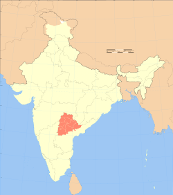
List of districts of Telangana
History
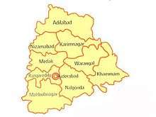
Telangana region of Hyderabad State did consist of 8 Districts in 1948 when it was inducted in Dominion of India; they are Atraf-i-Baldah (Hyderabad), Mahbubnagar district, Medak district, Nalgonda district (Nalgundah), Nizamabad districts, Adilabad, Karimnagar, and Warangal districts.[2] Khammam district was created by bifurcation of Warangal district on 1 October 1953.[3] Andhra Pradesh was formed by merging Telangana region of Hyderabad State and Andhra state on 1 November. Bhadrachalam division and Aswaraopet taluka parts was merged in Khammam district from Godavari districts for better Administration.[3] Hyderabad district was split into Hyderabad Urban District and Hyderabad Rural District on 15 August 1978.Hyderabad Urban District was made by 4 Talukas are Charminar, Golkonda, Mushirabad and Secunderabad Talukas which consist of only MCH area, Secunderabad cantonment and Osmania University. Hyderabad rural district was later renamed as Ranga Reddy District.[4]
Telangana carved out from with 10 districts from Andhra Pradesh. Seven mandals of Bhadrachalam division were given back to East Godavari district.[5][6] 21 new districts were created on 11 October 2016, which lead to 31 districts in Telangana. All districts were divided into minimum 2 to maximum 5 except Hyderabad district which was untouched.[7] Two new districts, Mulugu and Narayanpet were created on 17 February 2019, taking the total number of districts to 33.[8] Narayanpet district has 11 mandals.
District statistics
In terms of area, Bhadradri Kothagudem is the largest district with an area of 7,483 km2 (2,889 sq mi) and Hyderabad is the smallest with 217 km2 (84 sq mi). Hyderabad district is the most populated district with a population of 39,43,323 and Mulugu is the least populated with 2,94,671. Telangana consist of 68 Revenue Divisions and 584 Revenue Mandals(Tehsil).[9]
| S. No. | Name | Headquarters | Area (km2) | Population (2011 census) |
No.of mandals | Density (per km2) |
Urban (%) | Literacy (%) | Sex ratio | Map |
|---|---|---|---|---|---|---|---|---|---|---|
| 1 | Adilabad | Adilabad | 4,153 | 708,972 | 18 | 171 | 23.66 | 63.46 | 978 | .svg.png) |
| 2 | Bhadradri Kothagudem | Kothagudem | 7,483 | 1,069,261 | 23 | 143 | 31.71 | 66.40 | 1008 |  |
| 3 | Hyderabad | Hyderabad | 217 | 3,943,323 | 16 | 18172 | 100 | 83.25 | 954 | .svg.png) |
| 4 | Jagitial | Jagitial | 2,419 | 985,417 | 18 | 407 | 22.46 | 60.26 | 1036 |  |
| 5 | Jangaon | Jangaon | 2,188 | 566,376 | 13 | 259 | 12.60 | 61.60 | 997 | 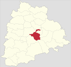 |
| 6 | Jayashankar Bhupalpally | Bhupalpally | 6,175 | 711,434 | 20 | 115 | 7.57 | 58.97 | 1009 |  |
| 7 | Jogulamba Gadwal | Gadwal | 2,928 | 609,990 | 12 | 208 | 10.36 | 49.87 | 972 | 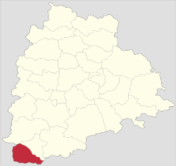 |
| 8 | Kamareddy | Kamareddy | 3,652 | 972,625 | 22 | 266 | 12.71 | 56.51 | 1033 | 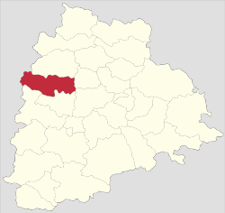 |
| 9 | Karimnagar | Karimnagar | 2,128 | 1,005,711 | 16 | 473 | 30.72 | 69.16 | 993 | 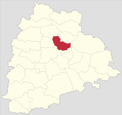 |
| 10 | Khammam | Khammam | 4,361 | 1,401,639 | 21 | 321 | 22.60 | 65.95 | 1005 | .svg.png) |
| 11 | Komaram Bheem | Komaram Bheem | 4,878 | 515,812 | 15 | 106 | 16.86 | 56.72 | 998 |  |
| 12 | Mahabubabad | Mahabubabad | 2,877 | 774,549 | 16 | 269 | 9.86 | 57.13 | 996 | 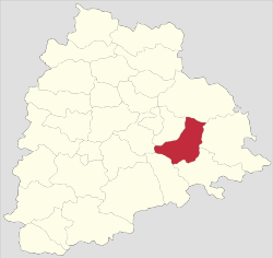 |
| 13 | Mahabubnagar | Mahabubnagar | 5,285 | 1,486,777 | 26 | 281 | 20.73 | 60.97 | 995 |  |
| 14 | Mancherial | Mancherial | 4,016 | 807,037 | 18 | 201 | 43.85 | 64.35 | 977 | 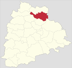 |
| 15 | Medak | Medak | 2,786 | 767,428 | 20 | 275 | 7.67 | 56.12 | 1027 | .svg.png) |
| 16 | Medchal–Malkajgiri | Shamirpet | 1,084 | 2,440,073 | 14 | 2251 | 91.40 | 82.48 | 957 | 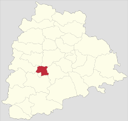 |
| 17 | Mulugu | Mulugu | 3,881 | 294,671 | 09 | 124 | 05 | 62.26 | 968 |  |
| 18 | Nagarkurnool | Nagarkurnool | 6,545 | 893,308 | 22 | 142 | 10.19 | 54.38 | 968 | 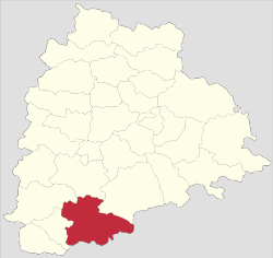 |
| 19 | Narayanpet | Narayanpet | 2336.44 | 5,66,874 | 11 | 243 | 7.36 | 49.93 | 1009 | 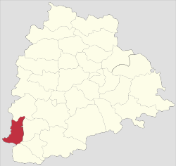 |
| 20 | Nalgonda | Nalgonda | 7,122 | 1,618,416 | 31 | 227 | 22.76 | 63.75 | 978 | .svg.png) |
| 21 | Nirmal | Nirmal | 3,845 | 709,418 | 19 | 185 | 21.38 | 57.77 | 1046 | 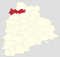 |
| 22 | Nizamabad | Nizamabad | 4,288 | 1,571,022 | 27 | 366 | 29.58 | 64.25 | 1044 | .svg.png) |
| 23 | Peddapalli | Peddapalli | 2,236 | 795,332 | 14 | 356 | 38.22 | 65.52 | 992 | 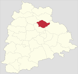 |
| 24 | Rajanna Sircilla | Sircilla | 2,019 | 552,037 | 13 | 273 | 21.17 | 62.71 | 1014 | 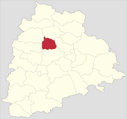 |
| 25 | Ranga Reddy | Shamshabad | 5,031 | 2,446,265 | 27 | 486 | 58.05 | 71.88 | 950 |  |
| 26 | Sangareddy | Sangareddy | 4,403 | 1,527,628 | 26 | 347 | 34.69 | 64.08 | 965 |  |
| 27 | Siddipet | Siddipet | 3,632 | 1,012,065 | 22 | 279 | 13.74 | 61.61 | 1008 |  |
| 28 | Suryapet | Suryapet | 3,607 | 1,099,560 | 23 | 305 | 15.56 | 64.11 | 996 |  |
| 29 | Vikarabad | Vikarabad | 3,386 | 927,140 | 18 | 274 | 13.48 | 57.91 | 1001 |  |
| 30 | Wanaparthy | Wanaparthy | 2,152 | 577,758 | 14 | 268 | 15.97 | 55.67 | 960 |  |
| 31 | Warangal Rural | Warangal | 2,175 | 718,537 | 15 | 330 | 6.99 | 61.26 | 994 | 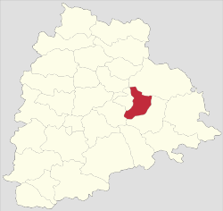 |
| 32 | Warangal Urban | Warangal | 1,309 | 1,080,858 | 11 | 826 | 68.51 | 76.17 | 997 | 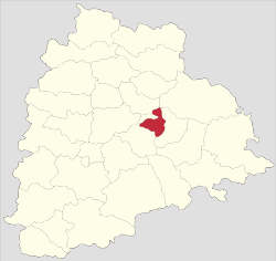 |
| 33 | Yadadri Bhuvanagiri | Bhongir | 3,092 | 739,448 | 16 | 239 | 16.66 | 65.2402221 | 973 | 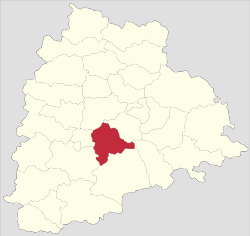 |
| Total | – | – | 112,077 | 35,003,674 | 584 | 312 | 38.88 | 66.54 | 988 | – |
See also
- List of mandals in Telangana
- List of districts in India
References
- "Telangana State Portal Districts". www.telangana.gov.in. Retrieved 23 April 2019.
- Yazdani, Ghulam. "Hyderabad State". Atlantic Publishers & Distri – via Google Books.
- "Know Your Corporation".
- Law, Gwillim (25 September 2011). "Districts of India". Statoids. Retrieved 11 October 2011.
- "The Andhra Pradesh Reorganisation (Amendment) Bill, 2014" Accessed 13 July 2014
- "Protests against Centre, Andhra Pradesh in Khammam over Polavaram Bill". Deccan Chronicle, 12 July 2014. Accessed 13 July 2014.
- "New districts". Andhra Jyothy.com. 8 October 2016. Retrieved 8 October 2016.
- "Telangana gets two new districts: Narayanpet and Mulugu". The New Indian Express. Retrieved 31 March 2019.
- "Archived copy". Archived from the original on 8 July 2017. Retrieved 17 December 2016.CS1 maint: archived copy as title (link)
External links
| portal | |
|---|---|
| Dynasties |
|
| Districts |
|
| Commissionerates |
|
| Major cities | |
| Tourism |
|
| Municipal corporations | |
| Related lists |
|
Template:Districts of Telangana