List of crossings of the Missouri River

This is a list of bridges and other crossings of the Missouri River from the Mississippi River upstream to its source(s).
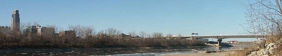
The I-480 bridge over the Missouri River between Council Bluffs, Iowa and Downtown Omaha, Nebraska.

Crossings

Crossing Carries Location Coordinates

Missouri

Mouth of Missouri River

38°49′01″N 90°07′18″W
Lewis Bridge US 67 Spanish Lake and West Alton 38°50′33″N 90°14′08″W
Bellefontaine Bridge BNSF Railway 38°50′37″N 90°14′11″W
Discovery Bridge Route 370 Bridgeton and Saint Charles 38°47′53″N 90°28′01″W
Wabash Bridge Norfolk Southern Railway
Former Wabash Railroad
38°47′51″N 90°28′02″W
Old St. Charles Bridge (demolished) Former Route 115
Former US 40
38°47′00″N 90°28′36″W
Blanchette Memorial Bridge Interstate 70 Maryland Heights and Saint Charles 38°45′52″N 90°28′57″W
Veterans Memorial Bridge Route 364 38°44′11″N 90°31′19″W
Daniel Boone Bridge Interstate 64
US 40
US 61
Chesterfield and Weldon Spring 38°41′13″N 90°39′46″W
Washington Bridge Route 47 Washington 38°33′27″N 90°59′54″W
Hermann Bridge (demolished) Hermann 38°42′34″N 91°26′18″W
Christopher S. Bond Bridge Route 19 38°42′34″N 91°26′20″W
Jefferson City Bridge US 54
US 63
Jefferson City 38°35′15″N 92°10′42″W
Rocheport Bridge Interstate 70 11 miles west of Columbia 38°57′35″N 92°32′41″W
Boonslick Bridge US 40
Route 5
Route 87
Boonville 38°58′51″N 92°44′45″W
Missouri-Kansas-Texas (MKT) Bridge Abandoned Railway 38°58′45″N 92°45′16″W
Glasgow Bridge (Old bridge was replaced in 2009) Route 240 Glasgow 39°13′21″N 92°51′00″W
Glasgow Railroad Bridge Kansas City Southern Railway 39°13′22″N 92°51′03″W
Miami Bridge (Old bridge was replaced in 2010) Route 41 Miami 39°19′45″N 93°13′31″W
Waverly Bridge (Old bridge was replaced in 2005) US 24
US 65
Waverly 39°12′54″N 93°30′56″W
Ike Skelton Bridge Route 13 Lexington 39°12′35″N 93°51′48″W
Lexington Bridge (demolished) 39°11′13″N 93°53′47″W
Sibley Railroad Bridge BNSF Railway Sibley 39°10′48″N 94°10′45″W
Liberty Bend Bridge Route 291 Sugar Creek and River Bend 39°10′06″N 94°23′43″W
Harry S. Truman Bridge Union Pacific
Canadian Pacific
Kansas City 39°08′41″N 94°29′05″W
I-435 Bridge Interstate 435 Kansas City and Randolph 39°09′04″N 94°29′54″W
Chouteau Freeway Bridge Route 269 Kansas City and North Kansas City 39°08′42″N 94°32′03″W
Paseo Bridge (Demolished) Interstate 29
Interstate 35
US 71
39°07′22″N 94°33′58″W
Christopher S. Bond Bridge Interstate 29
Interstate 35
US 71
39°07′21″N 94°33′59″W
Heart of America Bridge Route 9 Kansas City and North Kansas City 39°06′59″N 94°34′47″W
ASB Bridge BNSF Railway 39°07′02″N 94°34′44″W
Hannibal Bridge (demolished) Hannibal & St. Joseph Railroad
BNSF Railway
39°06′46″N 94°35′20″W
Second Hannibal Bridge BNSF Railway
Norfolk Southern Railway
39°06′46″N 94°35′20″W
Broadway Bridge US 169 39°06′43″N 94°35′22″W

Kansas - Missouri

US 69 Missouri River Bridge US 69 Kansas City, Kansas and Riverside, Missouri 39°09′23″N 94°37′24″W
Platte Purchase Bridge (demolished) US 69 North 39°09′23″N 94°37′23″W
Fairfax Bridge (demolished) US 69 South 39°09′23″N 94°37′24″W
I-635 Bridge I-635 39°09′14″N 94°39′03″W
I-435 Bridge I-435 Kansas City, Kansas and Parkville, Missouri 39°11′31″N 94°46′13″W
Terminal Bridge (demolished) Railway Leavenworth and Platte County, Missouri 39°19′02″N 94°54′24″W
Centennial Bridge Route 92
K-92
39°19′47″N 94°54′32″W
Kansas and Missouri Bridge (demolished) Route 92
K-92
Leavenworth County, Kansas and Platte County, Missouri 39°20′59″N 94°54′38″W
Amelia Earhart Bridge US 59 Atchison and Buchanan County, Missouri 39°33′35″N 95°06′48″W
Atchison Rail bridge BNSF Railway 39°33′37″N 95°06′47″W
Pony Express Bridge US 36 Elwood, Kansas and St. Joseph 39°44′56″N 94°51′34″W
St. Joseph Swing Bridge Union Pacific 39°44′57″N 94°51′34″W

Nebraska - Missouri

Rulo Bridge (Old Bridge was replaced in 2013) US 159 Rulo, Nebraska and Holt County, Missouri 40°03′15″N 95°25′15″W
Rulo Rail Bridge BNSF Railway 40°03′16″N 95°25′15″W
Brownville Bridge US 136 Brownville, Nebraska and Atchison County, Missouri 40°23′57″N 95°39′06″W

Nebraska - Iowa

Nebraska City Bridge NE 2
IA 2
Nebraska City, Nebraska 40°40′14″N 95°49′51″W
Railroad bridge (demolished)
Waubonsie Bridge (demolished)
Pontoon bridge (demolished)
Plattsmouth Bridge Former US 34 Plattsmouth, Nebraska 41°00′03″N 95°52′01″W
Burlington and Missouri River Railroad Bridge BNSF Railway 41°00′06″N 95°52′02″W
Pipeline Bridge 41°00′10″N 95°52′06″W
US 34 Missouri River Bridge US 34 Near Bellevue, Nebraska and Glenwood, Iowa
Bellevue Bridge Former NE 370
Former IA 370
Bellevue, Nebraska 41°08′19″N 95°52′46″W
South Omaha Veterans Memorial Bridge (Old bridge was replaced in 2010) US 275
NE 92
IA 92
Omaha and Council Bluffs 41°12′40″N 95°55′35″W
Interstate 80 Bridge I-80 41°13′54″N 95°54′39″W
Union Pacific Missouri River Bridge Union Pacific Railroad 41°14′59″N 95°55′02″W
Ak-Sar-Ben Bridge (demolished) 41°15′32″N 95°55′17″W
Grenville Dodge Memorial Bridge/Gerald R. Ford Freeway I-480
US 6
41°15′35″N 95°55′18″W
Bob Kerrey Pedestrian Bridge 41°15′17″N 95°55′31″W
Illinois Central Missouri River Bridge 41°16′41″N 95°53′28″W
Mormon Bridge I-680 North Omaha 41°20′44″N 95°57′26″W
Blair Bridge (Abraham Lincoln Memorial Bridge) US 30 Blair, Nebraska 41°33′04″N 96°05′44″W
Blair Bridge Union Pacific Railroad 41°33′05″N 96°05′44″W
Burt County Missouri River Bridge NE 51
IA 175
Decatur, Nebraska 42°00′24″N 96°14′31″W
Sergeant Floyd Memorial Bridge I-129
US 20
US 75
South Sioux City, Nebraska and Sioux City 42°26′49″N 96°22′48″W
Rail Bridge BNSF Railway 42°28′29″N 96°23′07″W
Siouxland Veterans Memorial Bridge US 77 42°29′15″N 96°24′49″W

Nebraska - South Dakota

Vermillion-Newcastle Bridge NE 15
SD 19
4 miles south of Vermillion, South Dakota. 42°43′08″N 96°57′06″W
Meridian Highway Bridge Former US 81, now pedestrian bridge Yankton, South Dakota. 42°51′53″N 97°23′38″W
Discovery Bridge US 81 42°51′56″N 97°23′49″W
Gavins Point Dam Crest Road 5 miles west of Yankton
Lewis and Clark Lake.
42°51′45″N 97°29′06″W
Chief Standing Bear Memorial Bridge NE 14
SD 37
3 miles east of Niobrara, Nebraska. 42°46′00″N 97°59′15″W

South Dakota

Fort Randall Dam US 18
US 281
West of Pickstown
Lake Francis Case
43°04′01″N 98°33′10″W
Bridge SD 44 14 miles west of Platte 43°23′12″N 99°07′56″W
Chamberlain Rail Bridge Dakota Southern Railway Oacoma and Chamberlain 43°47′56″N 99°21′33″W
Lewis and Clark Memorial Bridge I-90 43°48′06″N 99°21′12″W
Chamberlain Bridge I-90 Business
Former US 16
43°48′48″N 99°20′33″W
Big Bend Dam SD 47 Just south of Fort Thompson
Lake Sharpe
44°02′53″N 99°26′53″W
Bridge US 14
US 83
SD 34
Fort Pierre and Pierre 44°22′15″N 100°22′10″W
Chicago and North Western Railroad Bridge Rapid City, Pierre and Eastern Railroad 44°22′25″N 100°22′10″W
Oahe Dam SD 1804 8 miles north of Pierre
Lake Oahe
44°27′00″N 100°24′13″W
Highway Bridge US 212 18 miles west of Gettysburg 45°01′04″N 100°17′41″W
Highway Bridge US 12
SD 20
Mobridge 45°33′55″N 100°28′08″W
Rail Bridge BNSF Railway 45°34′10″N 100°27′33″W

North Dakota

Expressway Bridge ND 810 Mandan and Bismarck 46°47′47″N 100°49′12″W
New Liberty Memorial Bridge (Open; Under Construction) I-94 Business 46°48′28″N 100°49′09″W
Liberty Memorial Bridge (demolished October 29, 2008)[1][2] I-94 Business 46°48′29″N 100°49′10″W
BNSF Rail Bridge BNSF Railway 46°49′05″N 100°49′37″W
Grant Marsh Bridge I-94 46°49′24″N 100°49′49″W
Bridge Alt. ND 200 Washburn 47°17′19″N 101°02′33″W
Garrison Dam ND 200 Pick City and Riverdale 47°29′53″N 101°24′38″W
Four Bears Bridge ND 23 New Town 47°58′46″N 102°33′42″W
Bridge US 85 Williston 48°06′31″N 103°43′00″W
Bridge ND 58 Buford 47°59′02″N 104°00′56″W

Montana[3]

Burlington Northern Rail Bridge (also known as Snowden Bridge, Nohly Bridge, and Great Northern Railroad Bridge)[4] BNSF Railway, originally Great Northern Railway (U.S.) Nohly 48°00′00″N 104°05′45″W
Culbertson Bridge MT 16 Culbertson 48°07′29″N 104°28′29″W
Highway Bridge Roosevelt Co. Rd. 480 South of Sprole 48°03′53″N 105°01′55″W
Lewis and Clark Bridge MT 13 East of Wolf Point 48°03′54″N 105°01′54″W
Fort Peck Dam MT 24 17 miles southeast of Glasgow, MT 48°00′13″N 106°24′41″W
Highway Bridge US 191 72 miles south of Malta, MT 47°37′52″N 108°41′04″W
McClelland Ferry Blaine Co. Rd. Road 300 / Fergus Co. Rd. 101 12 miles north of Winifred 47°44′15″N 109°23′29″W
Highway Bridge S-236 64 miles southeast of Big Sandy 47°44′20″N 109°37′33″W
Virgelle Ferry Chouteau Co. Rd. 430 Virgelle, MT 48°00′04″N 110°15′14″W
Loma Bridge Chouteau Co. Rd. 303 Loma, MT 47°55′17″N 110°29′43″W
Ft. Benton Old Bridge Pedestrian Bridge Ft. Benton 47°49′02″N 110°39′58″W
Chouteau County Memorial Bridge MT 80 47°48′54″N 110°40′02″W
Carter Ferry Chouteau Co. Rd. 100 5 miles southeast of Carter, MT 47°45′37″N 110°53′46″W
Moroney Dam 15 miles northeast of Great Falls, MT 47°34′53″N 111°03′36″W
Ryan Dam 12 miles northeast of Great Falls 47°34′11″N 111°07′29″W
Cochrane Dam 10 miles northeast of Great Falls 47°33′12″N 111°08′57″W
Rainbow Dam 8 miles east of Great Falls 47°32′05″N 111°12′17″W
Rail Bridge BNSF Railway Just above Rainbow Dam 47°32′06″N 111°12′18″W
Black Eagle Dam Just north of Great Falls 47°31′11″N 111°15′49″W
15th Street Bridge US 87 Great Falls 47°31′14″N 111°16′54″W
Historic 10th Street Bridge Pedestrian Bridge 47°31′14″N 111°17′26″W
9th Street Bridge 47°31′14″N 111°17′28″W
Central Avenue Bridge 47°30′26″N 111°18′46″W
Railroad Bridge BNSF Railway 47°30′9″N 111°18′43″W
Interstate Bridge I-315

US 89
MT 3
MT 200

47°29′36″N 111°18′48″W
Highway Bridge S-330 Ulm, Montana 47°25′49″N 111°30′09″W
Highway Bridge S-330 Cascade, Montana 47°16′11″N 111°41′46″W
Freeway Bridge I-15 1 mile south of Hardy 47°10′40″N 111°48′45″W
Hardy Bridge Former US 91 2.5 miles south of Hardy 47°10′02″N 111°50′05″W
Freeway Bridge I-15 2 miles north of Dearborn Exit 47°08′19″N 111°51′40″W
Freeway Bridges I-15 3/4 miles north of Dearborn Exit 47°07′54″N 111°52′28″W
Freeway Bridges I-15 1/4 mile north of Dearborn Exit 47°07′58″N 111°53′11″W
Freeway Bridge I-15 1½ miles south of Dearborn Exit, at mouth of Dearborn River 47°07′41″N 111°54′41″W
Freeway Bridge I-15 2½ miles north of Craig 47°06′02″N 111°56′58″W
Highway Bridge Lewis and Clark Co. Rd. 13 B Craig 47°04′28″N 111°57′41″W
Highway Bridge Craig Frontage Road
Possibly former US 91
3½ miles northeast of Wolf Creek 47°01′08″N 112°00′44″W
Holter Dam 4 miles southeast of Wolf Creek
Holter Lake
Gates of the Mountains Wilderness
46°59′28″N 112°00′17″W
Hauser Dam 6 miles north of the east end of

S-453

46°45′54″N 111°53′13″W
Trout Creek Canyon Bridge York Road / S-280 15 miles northeast of Helena 46°42′48″N 111°48′23″W
Canyon Ferry Dam S-284 19 miles east of Helena 46°38′55″N 111°43′41″W
Highway Bridge US 12

US 287

1 mile north of Townsend 46°20′07″N 111°31′54″W
Railroad Bridge Montana RailLink 1 mile north of Townsend 46°20′05″N 111°31′58″W
Highway Bridge US 287 1/2 mile north of Toston 46°10′27″N 111°26′45″W
Toston Bridge Broadwater Co. Rd. 415C (formerly US 287) Toston 46°10′19″N 111°26′38″W
Toston Dam 8 miles south of Toston 46°07′12″N 111°24′30″W
Abandoned Rail Bridge Old Milwaukee Road Line At mouth of Sixteen Mile Creek 46°06′21″N 111°24′01″W

Mouth of Gallatin River

45°56′19″N 111°29′35″W

Confluence of the Jefferson and the Madison Rivers
Beginning of the Missouri River

45°55′36″N 111°30′18″W

See also

References

  1. "Bridge rubble should be gone by Friday". Bismarck Tribune. Archived from the original on August 22, 2009. Retrieved October 9, 2008.
  2. "Archived copy". Archived from the original on January 1, 2009. Retrieved December 1, 2008.CS1 maint: archived copy as title (link)
  3. Montana Department of Transportation County Maps
  4. "Snowden Bridge, Spanning Missouri River, Nohly, Richland County, MT". Library of Congress.
This article is issued from Wikipedia. The text is licensed under Creative Commons - Attribution - Sharealike. Additional terms may apply for the media files.