North Dakota Highway 23
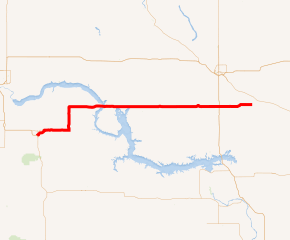
North Dakota Highway 23 (ND 23) is a 122.581-mile-long (197.275 km) east–west highway in northwestern North Dakota. ND 23's eastern terminus is at ND 41 near Velva, and its western terminus at U.S. Route 85 (US 85) in Watford City.
| ||||
|---|---|---|---|---|
ND 23 highlighted in red | ||||
| Route information | ||||
| Maintained by NDDOT | ||||
| Length | 122.581 mi[1] (197.275 km) | |||
| Existed | before 1940–present | |||
| Major junctions | ||||
| West end | ||||
| East end | ||||
| Location | ||||
| Counties | McKenzie, Mountrail, Ward, McHenry | |||
| Highway system | ||||
| ||||
.svg.png)
The only cities that ND 23 runs directly through are New Town and Watford City. It also runs through the unincorporated community of Keene. Other cities near the route include Makoti, Parshall, Plaza, Ryder, and Velva. Minot is 16 miles (26 km) north of the highway at its intersection with US 83.
Route description
ND 23 has its western terminus at a junction with US 85 and ND 200 in Watford City. The route starts concurrently with U.S. Route 85 Business (US 85 Bus.) for a short distance. It starts running north for less than a mile, then east outside of the city limits. After leaving Watford City, the route intersects with the first section of ND 1806, to which it serves as the southern terminus. The route then turns due north for about six miles at an intersection with ND 73. ND 23 then runs north through the small community of Keene. After turning eastward once more, the route shares another intersection with ND 1806 serving as the southern terminus of its second section. ND 23 intersects with ND 22 before leaving McKenzie County and entering Mountrail County by crossing Lake Sakakawea on the Four Bears Bridge.[2]
Just after entering Mountrail County, ND 23 has a junction with ND 1804 in New Town. This is the western end of a concurrency with ND 1804 in which ND 1804 is unsigned. Heading eastward seven more miles, the route serves as the southern terminus of ND 8. Just north of Parshall the route serves as the northern terminus of ND 37. This junction is also the eastern end of the route's concurrency with ND 1804. The route then runs three miles south of Plaza before entering Ward County.[2]
Two miles east of the county line, ND 23 runs just north of Makoti. The highway then serves as the northern terminus of ND 28, a short route that connects ND 23 to the small city of Ryder. Ten miles north of Max and sixteen miles south of Minot, ND 23 intersects US 83 before entering McHenry County. In McHenry County the highway travels east for about fifteen miles before meeting its eastern terminus south of Velva at ND 41.[2]
Suffixed routes
ND 23 has three suffixed routes.
- ND 23 Bus. (5.767 miles or 9.281 kilometres) is a business route of ND 23 in Watford City in McKenzie County. The route intersects ND 23 at each end and runs concurrent with US 85 Bus. for part of its length.
- ND 23A (1.526 miles or 2.456 kilometres) is an alternate route of ND 23 in Watford City in McKenzie County. The route intersects ND 23 Bus. and US 85 Bus. at its western terminus and ND 23 Bus. at the eastern terminus.
- ND 23B Truck (3.183 miles or 5.123 kilometres) is a truck route of ND 23 by New Town in Mountrail County. The route intersects ND 1804 at its western terminus and ND 23 at the eastern terminus.
Major intersections
| County | Location | mi[1] | km | Destinations | Notes |
|---|---|---|---|---|---|
| McKenzie | | 0.000 | 0.000 | Western terminus; southern terminus of US 85 Bus. | |
| | 0.533 | 0.858 | Eastern end of US 85 Bus. concurrency, western terminus of ND 23 Bus. | ||
| | 3.701 | 5.956 | Southern terminus of segment of ND 1806, eastern terminus of ND 23 Bus. | ||
| | 16.397 | 26.388 | Western terminus of ND 73 | ||
| | 31.339 | 50.435 | Southern terminus of segment of ND 1806 | ||
| | 38.209 | 61.491 | Northern terminus of ND 22 | ||
| Mountrail | New Town | 49.420 | 79.534 | Western end of ND 1804 concurrency | |
| | 51.446 | 82.794 | Eastern terminus of ND 23B Truck | ||
| | 56.405 | 90.775 | Southern terminus of ND 8 | ||
| | 66.370 | 106.812 | Western terminus of ND 37 Eastern end of ND 1804 concurrency | ||
| Ward | | 87.261 | 140.433 | Northern terminus of ND 28 | |
| | 105.517 | 169.813 | |||
| McHenry | | 122.581 | 197.275 | Eastern terminus | |
1.000 mi = 1.609 km; 1.000 km = 0.621 mi
| |||||
References
- Cartography Section, Planning/Asset Management Section (2015). Route and Mileage Map (PDF) (Map). c. 1:1,900,800. Bismarck: North Dakota Department of Transportation. Retrieved July 18, 2016.
- "Google Maps".
External links
| Wikimedia Commons has media related to North Dakota Highway 23. |
- The North Dakota Highways Page by Chris Geelhart
- North Dakota Signs by Mark O'Neil