Lake Quivira, Kansas
Lake Quivira /ˈleɪk kwɪˈvɪərə/ is a city in Johnson and Wyandotte counties in the State of Kansas, and part of the Kansas City Metropolitan Area. As of the 2010 census, the city population was 906.[6]
Lake Quivira, Kansas | |
|---|---|
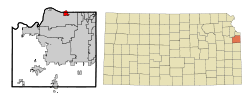 Location within Johnson County and Kansas | |
 KDOT map of Johnson County (legend) | |
| Coordinates: 39°2′33″N 94°46′11″W | |
| Country | United States |
| State | Kansas |
| Counties | Johnson, Wyandotte |
| Founded | 1920s |
| Incorporated | 1971 |
| Area | |
| • Total | 1.56 sq mi (4.04 km2) |
| • Land | 1.41 sq mi (3.65 km2) |
| • Water | 0.15 sq mi (0.39 km2) |
| Elevation | 909 ft (277 m) |
| Population | |
| • Total | 906 |
| • Estimate (2018)[3] | 938 |
| • Density | 580/sq mi (220/km2) |
| Time zone | UTC-6 (CST) |
| • Summer (DST) | UTC-5 (CDT) |
| ZIP code | 66217 |
| Area code | 913 |
| FIPS code | 20-37975 [4] |
| GNIS ID | 0484917 [5] |
| Website | cityoflakequivira.org |
History
Lake Quivira had its start in the 1920s when the developer Charles E. Gault and others set out to construct a subdivision on an artificial lake.[7]
Geography
Lake Quivira is located at 39°2′33″N 94°46′11″W (39.042371, −94.769810).[8] According to the United States Census Bureau, the city has a total area of 1.56 square miles (4.04 km2), of which, 1.41 square miles (3.65 km2) is land and 0.15 square miles (0.39 km2) is water.[1]
Demographics
| Historical population | |||
|---|---|---|---|
| Census | Pop. | %± | |
| 1980 | 1,087 | — | |
| 1990 | 983 | −9.6% | |
| 2000 | 932 | −5.2% | |
| 2010 | 906 | −2.8% | |
| Est. 2018 | 938 | [3] | 3.5% |
| U.S. Decennial Census[9] | |||
2010 census
As of the census[2] of 2010, there were 906 people, 365 households, and 304 families living in the city. The population density was 642.6 inhabitants per square mile (248.1/km2). There were 395 housing units at an average density of 280.1 per square mile (108.1/km2). The racial makeup of the city was 96.4% White, 0.6% African American, 0.7% Native American, 0.8% Asian, 0.8% from other races, and 0.9% from two or more races. Hispanic or Latino of any race were 1.8% of the population.
There were 365 households of which 27.4% had children under the age of 18 living with them, 80.5% were married couples living together, 1.9% had a female householder with no husband present, 0.8% had a male householder with no wife present, and 16.7% were non-families. 13.4% of all households were made up of individuals and 7.9% had someone living alone who was 65 years of age or older. The average household size was 2.48 and the average family size was 2.73.
The median age in the city was 52.9 years. 21.3% of residents were under the age of 18; 3.2% were between the ages of 18 and 24; 11.8% were from 25 to 44; 37.7% were from 45 to 64; and 26.2% were 65 years of age or older. The gender makeup of the city was 51.4% male and 48.6% female.
2000 census
As of the census[4] of 2000, there were 932 people, 381 households, and 326 families living in the city. The population density was 715.3 people per square mile (276.8/km²). There were 388 housing units at an average density of 297.8 per square mile (115.2/km²). The racial makeup of the city was 97.10% White, 0.86% African American, 0.54% Asian, and 1.50% from two or more races. Hispanic or Latino of any race were 2.04% of the population. 26.3% were of English, 24.2% German, 9.7% Irish and 8.3% American ancestry according to Census 2000.
There were 381 households out of which 24.7% had children under the age of 18 living with them, 81.4% were married couples living together, 2.6% had a female householder with no husband present, and 14.4% were non-families. 11.5% of all households were made up of individuals and 6.6% had someone living alone who was 65 years of age or older. The average household size was 2.45 and the average family size was 2.65.
In the city, the population not was spread out with 19.1% under the age of 18, 1.8% from 18 to 24, 17.0% from 25 to 44, 42.0% from 45 to 64, and 20.2% who were 65 years of age or older. The median age was 53 years. For every 100 females, there were 104.4 males. For every 100 females age 18 and over, there were 97.9 males.
The median income for a household in the city was $111,670, and the median income for a family was $119,186. Males had a median income of $100,000 versus $45,313 for females. The per capita income for the city was $60,567. About 0.9% of families and 1.3% of the population were below the poverty line, including none of those under the age of eighteen or sixty-five or over.
References
- "US Gazetteer files 2010". United States Census Bureau. Archived from the original on 2012-07-02. Retrieved 2012-07-06.
- "U.S. Census website". United States Census Bureau. Retrieved 2012-07-06.
- "Population and Housing Unit Estimates". Retrieved February 23, 2020.
- "U.S. Census website". United States Census Bureau. Retrieved 2008-01-31.
- "US Board on Geographic Names". United States Geological Survey. 2007-10-25. Retrieved 2008-01-31.
- "2010 City Population and Housing Occupancy Status". U.S. Census Bureau. Retrieved August 15, 2012.
- "Lake Quivira, Kansas". JoCoHistory. Johnson County Museum. Retrieved 12 June 2014.
- "US Gazetteer files: 2010, 2000, and 1990". United States Census Bureau. 2011-02-12. Retrieved 2011-04-23.
- United States Census Bureau. "Census of Population and Housing". Retrieved September 2, 2014.
External links
| Wikimedia Commons has media related to Lake Quivira, Kansas. |
- City
- Maps
- Lake Quivira City Map, KDOT
Municipalities and communities of Johnson County, Kansas, United States | ||
|---|---|---|
| Cities | 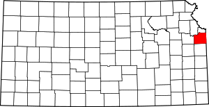 Map of Kansas highlighting Johnson County | |
| Unincorporated communities | ||
| Townships | ||
| Footnotes | ‡This populated place also has portions in an adjacent county or counties | |
Municipalities and communities of Wyandotte County, Kansas, United States | ||
|---|---|---|
| Cities |  Map of Kansas highlighting Wyandotte County | |
| Neighborhoods in Kansas City |
| |
| Footnotes | ‡This populated place also has portions in an adjacent county or counties | |
Kansas City metropolitan area's cities and counties | ||
|---|---|---|
| Central city | 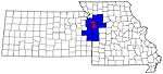 | |
| Largest cities (over 100,000 in 2000) | ||
| Medium-sized cities (10,000 to 100,000 in 2000) | ||
| Smaller Cities (between 5,000 and 9,900 in 2010) | ||
| Counties | ||