Olathe Township, Johnson County, Kansas
Olathe Township is one of seven townships in Johnson County, Kansas, USA. As of the 2010 census, its population was 137,324. It contains the city of Olathe, Kansas (for which it is named) and 0.53 Square Miles of De Soto, Kansas & Lexington Township, Kansas
Olathe Township | |
|---|---|
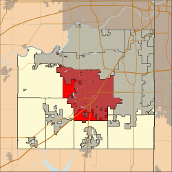 Location in Johnson County | |
| Coordinates: 38°53′33″N 94°53′24″W | |
| Country | United States |
| State | Kansas |
| County | Johnson |
| Area | |
| • Total | 76.42 sq mi (197.9 km2) |
| • Land | 70.22 sq mi (181.9 km2) |
| • Water | 6.20 sq mi (16.1 km2) |
| Elevation | 780 ft (240 m) |
| Population (2010) | |
| • Total | 137,324 |
| • Estimate (2011) | 134,901 |
| • Density | 1,800/sq mi (690/km2) |
| Time zone | Central |
| ZIP codes | 66018, 66051, 66061, 66062 |
| GNS feature ID | 479196 |
Adjacent Townships
- Lexington Township Northwest
- Gardner Township Southwest
Cemeteries
- Olathe Memorial Cemetery
- Asa Smith Cemetery
Emergency Services
Police
- Johnson County Sheriff
- Olathe Police
Fire
- Olathe Fire Department
Medical (EMS)
- Johnson County Med-Act
Transportation
Rail
- BNSF Railway Emporia Subdivision
- Union Pacific Railway
Major Roads
- Santa Fe Street (formerly known as

- Quivira Road
- Metcalf Avenue
- Parker Street
- Mur-Len/Strang Line Road
- Lackman Road
- Blackbob Road
- Cedar Creek Parkway
- College Parkway
Lakes, Streams & Ponds
- Lake Olathe
- Mill Creek
- Little Mill Creek
Parks
- Ernie Miller Nature Park
Notable Locations
- Johnson County Courthouse
- Olathe Medical Center
- Garmin Headquarters
- Great Mall of the Great Plains
- Great Plaza of the Great Plains
- Prince of Peace Catholic Church
- Johnson County Airport
- New Century Aircenter
School districts
- Gardner School District 231
- De Soto Unified School District 232
- Olathe Unified School District 233
- Blue Valley School District
External links
- "Township of Olathe". Geographic Names Information System. United States Geological Survey. Retrieved 2014-01-04.
Municipalities and communities of Johnson County, Kansas, United States | ||
|---|---|---|
| Cities | 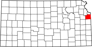 Map of Kansas highlighting Johnson County | |
| Unincorporated communities | ||
| Townships | ||
| Footnotes | ‡This populated place also has portions in an adjacent county or counties | |
This article is issued from Wikipedia. The text is licensed under Creative Commons - Attribution - Sharealike. Additional terms may apply for the media files.