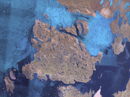
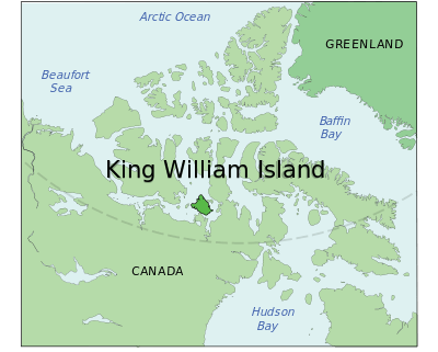
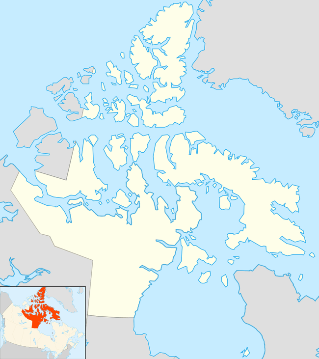
King William Island
King William Island (French: Île du Roi-Guillaume; previously: King William Land; Inuktitut: Qikiqtaq)[1] is an island in the Kitikmeot Region of Nunavut, which is part of the Arctic Archipelago. In area it is between 12,516 km2 (4,832 sq mi)[2] and 13,111 km2 (5,062 sq mi)[3] making it the 61st-largest island in the world and Canada's 15th-largest island. Its population, as of the 2016 census, was 1,279,[4] all of whom live in the island's only community, Gjoa Haven.[5]
| Native name: Qikiqtaq | |
|---|---|
 | |
 | |
 King William Island  King William Island | |
| Geography | |
| Location | Northern Canada |
| Coordinates | 69°00′N 97°30′W |
| Archipelago | Arctic Archipelago |
| Area | 12,516 km2 (4,832 sq mi) -13,111 km2 (5,062 sq mi) |
| Area rank | 61st |
| Highest elevation | 137 m (449 ft) |
| Highest point | Mount Matheson |
| Administration | |
Canada | |
| Territory | Nunavut |
| Largest settlement | Gjoa Haven (pop. 1,279) |
| Demographics | |
| Population | 1,324 (2011) |
| Pop. density | 0.08/km2 (0.21/sq mi) |
| Ethnic groups | Inuit |
While searching for the Northwest Passage, a number of polar explorers visited, or spent their winters on, King William Island.
Geography

The island is separated from the Boothia Peninsula by the James Ross Strait to the northeast, and the Rae Strait to the east. To the west is the Victoria Strait and beyond it Victoria Island. Within the Simpson Strait, to the south of the island, is Todd Island, and beyond it, further to the south, is the Adelaide Peninsula. Queen Maud Gulf lies to the southwest.
Some places on the coast are: (counter clockwise from the northern tip) Cape Felix, Victory Point and Gore Point at the mouth of an inlet, Point Le Vesconte, Erebus Bay, Cape Crozier, (south side) Terror Bay, Irving Islands, Washington Bay, Cape Herschel, Gladman Point, entrance to Simpson Strait, Todd Islets, (east side) Gjoa Haven, Matheson Peninsula, Latrobe Bay, Cape Norton at mouth of Peel Inlet, Matty Island, Tennent Islands, Clarence Islands, Cape Felix.[6]
Wildlife
The island is known for its large populations of caribou, which summer there before migrating in the autumn by walking south over the sea ice.
Role in Arctic exploration
John Ross
The island was long occupied by Inuit people, who had a culture adapted to the extreme environment. In 1830, the British explorer John Ross named it "King William Land" for the reigning British King William IV; Ross thought at the time that it was a peninsula. In 1834, George Back, another Arctic explorer, viewed its south shore from Chantry Inlet and recognized it as an island.
John Franklin
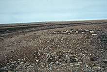
John Franklin, another British explorer, made an Arctic expedition about a decade later; his two ships became stranded in 1846 when frozen in the sea ice northwest of the island. After abandoning the two ships, most of the crew died from exposure and starvation as they attempted to walk south near the western coastline. Two of Franklin's men were buried at Hall Point on the island's south coast. The ships were believed lost forever, as many subsequent expeditions were unable to find them.
On 9 September, 2014, Canada's Prime Minister Stephen Harper announced that the Victoria Strait Expedition had located one of Franklin's two ships beneath shallow waters south of King William Island. It is preserved in very good condition; the side-scan sonar could detect the deck planking.[7][8] By the beginning of October, the wreck had been identified as HMS Erebus.[9] The other expedition vessel, HMS Terror, was found in 2016 in Terror Bay, off the south-west coast of King William Island.[10]
George Porter
George Porter was born on a whaling ship near Herschel Island in 1895 to Mary Kappak and W.P.S. Porter. George was schooled in Alaska. In 1913 he was a sailor on the Elvira and travelled with the explorer Vilhjalmur Stefanson. After briefly working as a reindeer herder in Siberia, he enlisted with the US military near the end of the First World War. In 1919, George was discharged from the Army in Iowa. In 1921 George sailed to Australia. Later George guided RCMP commander Henry Larsen on many trips. George Porter eventually made Gjoa Haven on King William Island his home, where he worked as the manager of the Hudson's Bay Company trading post for a career of 25 years. [11]
Roald Amundsen
In 1903, Norwegian explorer Roald Amundsen, looking for the Northwest Passage, sailed through the James Ross Strait and stopped at a natural harbour on the island's south coast. Unable to proceed due to sea ice, he spent the winters of 1903–1904 and 1904–1905 there. During his stays, he learned Arctic living skills from the local Netsilik Inuit. He used his ship Gjøa as a base for explorations in the summer of 1904, during which he traveled by dogsled on the Boothia Peninsula and to the North Magnetic Pole. After 22 months on the island, Amundsen left in August 1905. The harbour where he lived has the island's only settlement, Gjoa Haven. Amundsen used skills learned from the Inuit when he made his later expedition to the South Pole.
Climate
Like many places in the high Arctic the island has a tundra climate (Köppen: ET), its winter is strict and the summer on few occasions are cool, melting part of the ice, with low precipitation is a "cold desert".[12]
| Climate data for Gladman Point Airport (abandoned DEW Line site, CAM-2), 68°40′N 97°48′W elevation: 25 m (82 ft), Canadian Climate Normals 1961-1990 Station Data and extremes | |||||||||||||
|---|---|---|---|---|---|---|---|---|---|---|---|---|---|
| Month | Jan | Feb | Mar | Apr | May | Jun | Jul | Aug | Sep | Oct | Nov | Dec | Year |
| Record high °C (°F) | −5.0 (23.0) |
−4.4 (24.1) |
−1.7 (28.9) |
2.2 (36.0) |
3.9 (39.0) |
21.1 (70.0) |
24.4 (75.9) |
23.9 (75.0) |
13.9 (57.0) |
6.7 (44.1) |
−0.6 (30.9) |
−4.0 (24.8) |
24.4 (75.9) |
| Average high °C (°F) | −30.8 (−23.4) |
−31.5 (−24.7) |
−27.3 (−17.1) |
−17.2 (1.0) |
−5.9 (21.4) |
3.8 (38.8) |
11.3 (52.3) |
8.5 (47.3) |
1.3 (34.3) |
−7.8 (18.0) |
−19.7 (−3.5) |
−26.3 (−15.3) |
−11.8 (10.8) |
| Daily mean °C (°F) | −34.2 (−29.6) |
−34.9 (−30.8) |
−31.4 (−24.5) |
−22.0 (−7.6) |
−9.8 (14.4) |
1.0 (33.8) |
7.2 (45.0) |
5.2 (41.4) |
−0.9 (30.4) |
−11.2 (11.8) |
−23.6 (−10.5) |
−29.8 (−21.6) |
−15.4 (4.4) |
| Average low °C (°F) | −38.3 (−36.9) |
−38.7 (−37.7) |
−35.7 (−32.3) |
−27.1 (−16.8) |
−13.8 (7.2) |
−2.0 (28.4) |
3.1 (37.6) |
1.9 (35.4) |
−3.2 (26.2) |
−14.6 (5.7) |
−27.5 (−17.5) |
−34.0 (−29.2) |
−19.2 (−2.5) |
| Record low °C (°F) | −50.0 (−58.0) |
−53.0 (−63.4) |
−48.3 (−54.9) |
−43.3 (−45.9) |
−31.1 (−24.0) |
−18.9 (−2.0) |
−1.7 (28.9) |
−6.1 (21.0) |
−17.5 (0.5) |
−33.4 (−28.1) |
−46.7 (−52.1) |
−47.2 (−53.0) |
−53.0 (−63.4) |
| Average precipitation mm (inches) | 1.7 (0.07) |
2.3 (0.09) |
2.5 (0.10) |
5.5 (0.22) |
9.4 (0.37) |
10.0 (0.39) |
23.5 (0.93) |
25.9 (1.02) |
18.9 (0.74) |
13.2 (0.52) |
5.0 (0.20) |
2.3 (0.09) |
120.4 (4.74) |
| Average rainfall mm (inches) | 0.0 (0.0) |
0.0 (0.0) |
0.0 (0.0) |
0.0 (0.0) |
1.0 (0.04) |
7.1 (0.28) |
23.4 (0.92) |
24.6 (0.97) |
12.4 (0.49) |
0.8 (0.03) |
0.0 (0.0) |
0.0 (0.0) |
69.2 (2.72) |
| Average snowfall cm (inches) | 1.7 (0.7) |
2.3 (0.9) |
2.5 (1.0) |
5.5 (2.2) |
8.4 (3.3) |
3.0 (1.2) |
0.2 (0.1) |
1.3 (0.5) |
6.5 (2.6) |
12.4 (4.9) |
5.0 (2.0) |
2.3 (0.9) |
51.2 (20.2) |
| Average precipitation days (≥ 0.2 mm (0.0079 in)) | 2 | 2 | 2 | 3 | 6 | 5 | 8 | 10 | 10 | 8 | 4 | 2 | 63 |
| Average rainy days (≥ 0.2 mm (0.0079 in)) | 0 | 0 | 0 | trace | trace | 3 | 8 | 9 | 5 | trace | 0 | 0 | 26 |
| Average snowy days (≥ 0.2 cm (0.079 in)) | 2 | 2 | 2 | 3 | 5 | 2 | trace | 1 | 5 | 8 | 4 | 2 | 38 |
| Source: Environment Canada Canadian Climate Normals 1981–2010[13] | |||||||||||||
| Climate data for Gjoa Haven Airport 68°38′08″N 95°51′01″W, elevation 49.9 m (164 ft) Canadian Climate Normals 1981-2010 Station Data | |||||||||||||
|---|---|---|---|---|---|---|---|---|---|---|---|---|---|
| Month | Jan | Feb | Mar | Apr | May | Jun | Jul | Aug | Sep | Oct | Nov | Dec | Year |
| Record high humidex | −7.4 | −11.3 | −6.6 | 0.2 | 2.6 | 19.4 | 26.7 | 23.0 | 16.0 | 4.2 | −1.4 | −1.9 | 26.7 |
| Record high °C (°F) | −6.0 (21.2) |
−11.0 (12.2) |
−5.0 (23.0) |
1.0 (33.8) |
6.5 (43.7) |
20.8 (69.4) |
24.1 (75.4) |
22.5 (72.5) |
15.4 (59.7) |
4.5 (40.1) |
−0.8 (30.6) |
−8.3 (17.1) |
24.1 (75.4) |
| Average high °C (°F) | −30.4 (−22.7) |
−30.7 (−23.3) |
−25.1 (−13.2) |
−16.0 (3.2) |
−5.9 (21.4) |
4.2 (39.6) |
12.1 (53.8) |
8.9 (48.0) |
2.1 (35.8) |
−6.7 (19.9) |
−19.0 (−2.2) |
−26.6 (−15.9) |
−11.1 (12.0) |
| Daily mean °C (°F) | −33.8 (−28.8) |
−34.0 (−29.2) |
−28.9 (−20.0) |
−20.4 (−4.7) |
−9.4 (15.1) |
1.4 (34.5) |
8.0 (46.4) |
5.8 (42.4) |
0.1 (32.2) |
−9.5 (14.9) |
−22.4 (−8.3) |
−29.9 (−21.8) |
−14.4 (6.1) |
| Average low °C (°F) | −37.1 (−34.8) |
−37.0 (−34.6) |
−32.6 (−26.7) |
−24.8 (−12.6) |
−12.9 (8.8) |
−1.5 (29.3) |
3.8 (38.8) |
2.7 (36.9) |
−2.0 (28.4) |
−12.3 (9.9) |
−25.8 (−14.4) |
−33.1 (−27.6) |
−17.7 (0.1) |
| Record low °C (°F) | −48.3 (−54.9) |
−50.2 (−58.4) |
−46.3 (−51.3) |
−40.0 (−40.0) |
−28.2 (−18.8) |
−17.0 (1.4) |
−1.1 (30.0) |
−5.0 (23.0) |
−14.3 (6.3) |
−32.0 (−25.6) |
−39.4 (−38.9) |
−44.0 (−47.2) |
−50.2 (−58.4) |
| Record low wind chill | −64.2 | −65.3 | −64.5 | −54.0 | −38.1 | −21.9 | 0.0 | −12.9 | −21.2 | −48.1 | −55.0 | −62.5 | −65.3 |
| Average precipitation mm (inches) | 8.3 (0.33) |
7.8 (0.31) |
12.9 (0.51) |
13.5 (0.53) |
15.0 (0.59) |
14.7 (0.58) |
21.2 (0.83) |
28.4 (1.12) |
24.2 (0.95) |
25.0 (0.98) |
11.4 (0.45) |
8.8 (0.35) |
191.0 (7.52) |
| Average rainfall mm (inches) | 0.0 (0.0) |
0.0 (0.0) |
0.0 (0.0) |
0.0 (0.0) |
1.8 (0.07) |
11.2 (0.44) |
20.8 (0.82) |
27.9 (1.10) |
15.9 (0.63) |
0.9 (0.04) |
0.0 (0.0) |
0.0 (0.0) |
78.4 (3.09) |
| Average snowfall cm (inches) | 9.7 (3.8) |
8.8 (3.5) |
15.8 (6.2) |
15.4 (6.1) |
15.2 (6.0) |
3.9 (1.5) |
0.4 (0.2) |
0.5 (0.2) |
8.8 (3.5) |
28.2 (11.1) |
13.4 (5.3) |
10.4 (4.1) |
130.4 (51.3) |
| Average precipitation days (≥ 0.2 mm (0.0079 in)) | 8.2 | 6.4 | 9.0 | 8.8 | 9.6 | 6.8 | 7.8 | 11.0 | 12.0 | 14.1 | 10.1 | 8.2 | 112.0 |
| Average rainy days (≥ 0.2 mm (0.0079 in)) | 0.0 | 0.0 | 0.0 | 0.0 | 0.8 | 5.3 | 7.8 | 10.6 | 7.4 | 0.5 | 0.0 | 0.0 | 32.5 |
| Average snowy days (≥ 0.2 cm (0.079 in)) | 8.2 | 6.4 | 9.0 | 8.8 | 9.3 | 1.9 | 0.2 | 0.6 | 5.8 | 14.1 | 10.4 | 8.2 | 82.7 |
| Average relative humidity (%) | 62.6 | 63.9 | 70.3 | 77.7 | 85.9 | 81.9 | 70.7 | 75.8 | 82.3 | 87.7 | 76.7 | 66.7 | 75.2 |
| Source: Environment Canada Canadian Climate Normals 1981–2010[14] | |||||||||||||
References
- Darren Keith, Jerry Arqviq (November 23, 2006). "Environmental Change, Polar Bears and Adaptation in the East Kitikmeot: An Initial Assessment Final Report" (PDF). Kitikmeot Heritage Society. Archived from the original on March 26, 2009. Retrieved 2008-01-23.CS1 maint: BOT: original-url status unknown (link)
- King William Island at the Atlas of Canada
- Other Arctic Islands Archived 2013-01-22 at the Wayback Machine, Atlas of Canada
- "2016 Community Profiles Gjoa Haven". Retrieved 2017-03-05.
- The surrounding Census Subdivision, Kitikmeot, Unorganized which includes the rest of King William Island, has a population of 0.
- Page 2 fig. 1 in Keenleyside, A., M. Bertulli, and H. C. Fricke. 1997. "The Final Days of the Franklin Expedition: New Skeletal Evidence". Arctic. 50, no. 1: 36.
- "Toronto Star: Ship from lost Franklin expedition found". thestar.com. 2014-09-09. Retrieved 2014-09-09.
- "Lost Franklin expedition ship found in the Arctic". CBC. 2014-09-09. Retrieved 2014-09-09.
- "Canada identifies long lost British explorer ship". The Daily Telegraph. 2014-10-01. Retrieved 2014-10-02.
- "The Guardian:Ship found in Arctic 168 years after doomed Northwest Passage attempt". The Guardian. 2016-09-12. Retrieved 2016-09-12.
- "Inuktitut" (PDF). March 1983. Retrieved 2020-05-19.
- Reconnaissance Geology of Portions of Victoria Island and Adjacent Regions Arctic Canada. Geological Society of America. 1947. ISBN 9780813710228.
- "Gladman Point A". Canadian Climate Normals 1981–2010. Environment Canada. Climate ID: 2302335. Retrieved 2019-07-15.
- "Gjoa Haven A". Canadian Climate Normals 1981–2010. Environment Canada. Climate ID: 2302335. Retrieved 2014-04-30.
- The Last Place on Earth, Roland Huntford, ISBN 0-349-11395-5.
Further reading
- Fraser, J. Keith. Notes on the Glaciation of King William Island and Adelaide Peninsula, N.W.T. Ottawa: Geographical Branch, Dept. of Mines and Technical Surveys, 1959.
- Taylor, J. Garth. Netsilik Eskimo Material Culture. The Roald Amundsen Collection from King William Island. Oslo: Universitetsforlaget, 1974. ISBN 82-00-08945-2
- Woodworth-Lynas, C. M. T. Surveying and Trenching an Iceberg Scour, King William Island, Arctic Canada. St. John's: Memorial University of Newfoundland, Centre for Cold Ocean Resources Engineering, 1985.