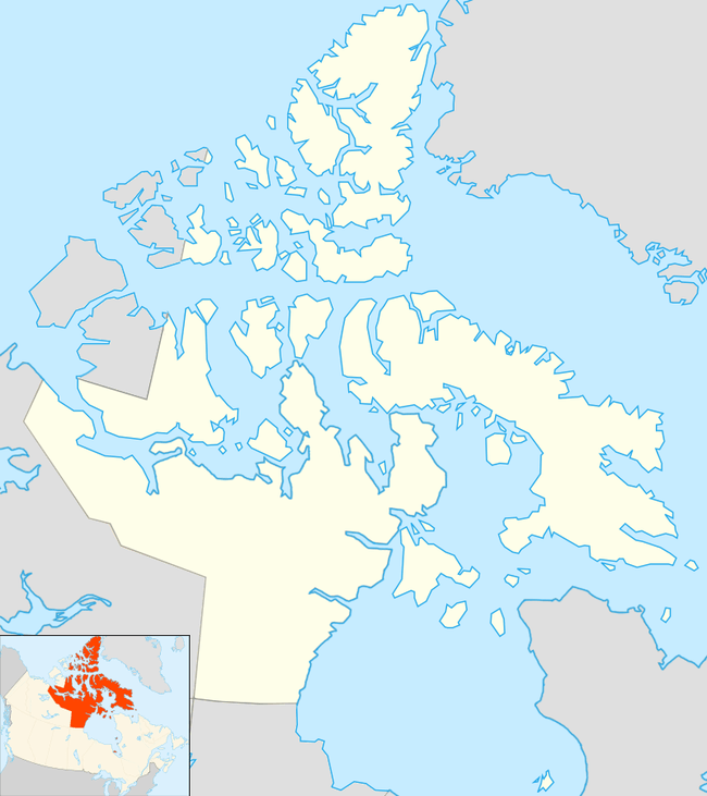
Chesterfield Inlet, Nunavut
Chesterfield Inlet (Inuktitut: Igluligaarjuk, syllabics: ᐃᒡᓗᓕᒑᕐᔪᒃ) is a hamlet located on the western shore of Hudson Bay, Kivalliq Region, in Nunavut Canada at the mouth of Chesterfield Inlet. Igluligaarjuk is the Inuktitut word for "place with few houses", it is the oldest community in Nunavut. The community is served by air, Chesterfield Inlet Airport, and by an annual supply known as sealift.
Chesterfield Inlet ᐃᒡᓗᓕᒑᕐᔪᒃ Igluligaarjuk | |
|---|---|
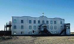 Chesterfield Inlet Mission Hospital | |
 Chesterfield Inlet  Chesterfield Inlet | |
| Coordinates: 63°20′27″N 090°42′22″W | |
| Country | Canada |
| Territory | Nunavut |
| Region | Kivalliq |
| Electoral district | Rankin Inlet North-Chesterfield Inlet |
| Settled | 1911, Hudson's Bay Company post |
| Incorporated (hamlet) | 1 April 1980 |
| Government | |
| • Mayor | Barnie Aggark |
| • Senior Administrative Officer | Richard Van Horne |
| • MLA | Cathy Towtongie |
| Area | |
| • Total | 141.10 km2 (54.48 sq mi) |
| Elevation | 11 m (36 ft) |
| Population (2016)[3] | |
| • Total | 437 |
| • Density | 3.1/km2 (8.0/sq mi) |
| Time zone | UTC−06:00 (CST) |
| • Summer (DST) | UTC−05:00 (CDT) |
| Canadian Postal code | XOC OBO |
| Area code(s) | 867 |
| Website | chesterfield-inlet.ca/ |
The Inuit people from the Chesterfield Inlet region are called Qaernermiut, though previously, they were referred to as Kenepitic, Kenepetu or Kenepitu.[5]
Demographics
As of the 2016 census the population was 437, an increase of 39.6% from the 2011 census.[3]
Broadband communications
The community has been served by the Qiniq network since 2005. Qiniq is a fixed wireless service to homes and businesses, connecting to the outside world via a satellite backbone. The Qiniq network is designed and operated by SSI Micro. In 2017, the network was upgraded to 4G LTE technology, and 2G-GSM for mobile voice.
Climate
| Climate data for Chesterfield Inlet | |||||||||||||
|---|---|---|---|---|---|---|---|---|---|---|---|---|---|
| Month | Jan | Feb | Mar | Apr | May | Jun | Jul | Aug | Sep | Oct | Nov | Dec | Year |
| Record high humidex | −7.4 | −8.0 | 1.6 | 1.5 | 12.6 | 23.8 | 35.4 | 37.0 | 20.8 | 12.1 | 1.4 | 0.2 | 37.0 |
| Record high °C (°F) | −3.0 (26.6) |
−5.5 (22.1) |
2.0 (35.6) |
3.5 (38.3) |
14.0 (57.2) |
26.0 (78.8) |
30.5 (86.9) |
27.0 (80.6) |
22.0 (71.6) |
10.0 (50.0) |
2.0 (35.6) |
−2.0 (28.4) |
30.5 (86.9) |
| Average high °C (°F) | −27.3 (−17.1) |
−26.9 (−16.4) |
−20.6 (−5.1) |
−11.1 (12.0) |
−2.3 (27.9) |
7.9 (46.2) |
15.2 (59.4) |
12.7 (54.9) |
5.7 (42.3) |
−1.8 (28.8) |
−12.7 (9.1) |
−21.1 (−6.0) |
−6.9 (19.6) |
| Daily mean °C (°F) | −30.9 (−23.6) |
−30.8 (−23.4) |
−25.1 (−13.2) |
−15.8 (3.6) |
−5.7 (21.7) |
4.3 (39.7) |
10.6 (51.1) |
9.2 (48.6) |
3.3 (37.9) |
−4.5 (23.9) |
−16.7 (1.9) |
−25.2 (−13.4) |
−10.6 (12.9) |
| Average low °C (°F) | −34.3 (−29.7) |
−34.2 (−29.6) |
−29.4 (−20.9) |
−20.1 (−4.2) |
−9.0 (15.8) |
0.5 (32.9) |
5.9 (42.6) |
5.7 (42.3) |
0.9 (33.6) |
−7.0 (19.4) |
−20.7 (−5.3) |
−29.1 (−20.4) |
−14.2 (6.4) |
| Record low °C (°F) | −46.0 (−50.8) |
−49.0 (−56.2) |
−45.0 (−49.0) |
−35.5 (−31.9) |
−29.0 (−20.2) |
−11.5 (11.3) |
−1.5 (29.3) |
−2.0 (28.4) |
−9.0 (15.8) |
−26.0 (−14.8) |
−37.5 (−35.5) |
−44.0 (−47.2) |
−49.0 (−56.2) |
| Record low wind chill | −66.3 | −70.7 | −64.7 | −50.5 | −33.6 | −18.3 | 0.0 | −9.5 | −17.9 | −40.1 | −54.6 | −60.9 | −70.7 |
| Average precipitation mm (inches) | 10.4 (0.41) |
9.6 (0.38) |
14.9 (0.59) |
15.5 (0.61) |
15.1 (0.59) |
23.3 (0.92) |
41.2 (1.62) |
51.2 (2.02) |
37.4 (1.47) |
26.6 (1.05) |
22.0 (0.87) |
14.0 (0.55) |
281.2 (11.07) |
| Average rainfall mm (inches) | 0.0 (0.0) |
0.0 (0.0) |
0.0 (0.0) |
0.1 (0.00) |
6.1 (0.24) |
19.7 (0.78) |
41.2 (1.62) |
51.2 (2.02) |
33.9 (1.33) |
11.7 (0.46) |
0.0 (0.0) |
0.0 (0.0) |
163.9 (6.45) |
| Average snowfall cm (inches) | 11.2 (4.4) |
10.2 (4.0) |
15.0 (5.9) |
17.0 (6.7) |
9.4 (3.7) |
3.7 (1.5) |
0.0 (0.0) |
0.0 (0.0) |
3.5 (1.4) |
15.0 (5.9) |
23.1 (9.1) |
15.4 (6.1) |
123.6 (48.7) |
| Average precipitation days (≥ 0.2 mm) | 4.2 | 3.7 | 4.3 | 5.0 | 4.9 | 6.0 | 7.9 | 9.9 | 9.7 | 8.8 | 7.6 | 5.4 | 77.3 |
| Average rainy days (≥ 0.2 mm) | 0.0 | 0.0 | 0.0 | 0.1 | 1.6 | 5.4 | 7.9 | 9.9 | 8.4 | 3.4 | 0.0 | 0.0 | 36.6 |
| Average snowy days (≥ 0.2 cm) | 4.2 | 3.7 | 4.4 | 4.9 | 3.3 | 0.7 | 0.0 | 0.0 | 1.5 | 5.7 | 7.7 | 5.4 | 41.4 |
| Average relative humidity (%) | 79.0 | 67.6 | 74.9 | 82.0 | 84.4 | 70.9 | 68.0 | 72.5 | 77.4 | 87.3 | 83.0 | 75.3 | 76.9 |
| Source: Environment Canada Canadian Climate Normals 1981–2010[6] | |||||||||||||
See also
References
- Nunavummiut vie for council positions in upcoming hamlet elections
- Results for the constituency of Rankin Inlet North-Chesterfield Inlet Archived 14 November 2013 at the Wayback Machine at Elections Nunavut
- "Statistics Canada: 2016 Census Profile". Statistics Canada. Retrieved 18 February 2017.
- Elevation at airport. Canada Flight Supplement. Effective 0901Z 30 January 2020 to 0901Z 26 March 2020.
- "Image is described as "this shows the tattooing of the Kenepitic [Qaernermiut] tribe"". cthistoryonline.org. 16 February 1904. Archived from the original on 23 December 2010. Retrieved 31 March 2008.
- "Chesterfield Inlet A" (CSV (4222 KB)). Canadian Climate Normals 1981–2010. Environment Canada. Climate ID: 2300707. Retrieved 30 September 2013.
Further reading
- King, David Paul. The History of the Federal Residential Schools for the Inuit Located in Chesterfield Inlet, Yellowknife, Inuvik and Churchill, 1955-1970. Theses Canada digitization project. Ottawa: Library and Archives Canada, 2000. ISBN 0-612-40475-7
- Tella, Subhas. Precambrian Geology of Parts of Tavani, Marble Island, and Chesterfield Inlet Map Areas, District of Keewatin A Progress Report. [Ottawa], Canada: Geological Survey of Canada, 1986. ISBN 0-660-12113-1
- Choque, Charles : 75ème anniversaire de la premiere mission catholique chez les Inuit de la Baie d'Hudson, Chesterfield Inlet 1912-1987 Igluligaarjuk. ISBN 0-9693266-0-2
External links
| Wikimedia Commons has media related to Chesterfield Inlet. |