Kitikmeot Region
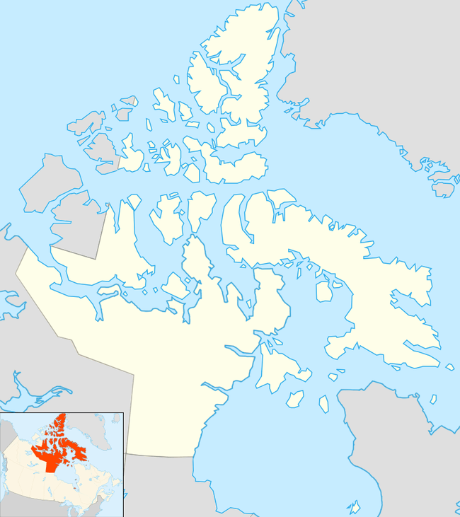
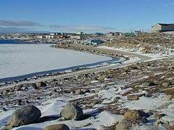
Kitikmeot Region (/ˈkɪtəkmjuːt/;[1] Inuktitut: Qitirmiut ᕿᑎᕐᒥᐅᑦ ) is an administrative region of Nunavut, Canada. It consists of the southern and eastern parts of Victoria Island with the adjacent part of the mainland as far as the Boothia Peninsula, together with King William Island and the southern portion of Prince of Wales Island. The regional seat is Cambridge Bay (population 1,766;[2]).
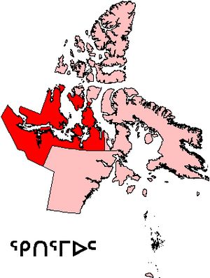
Before 1999, Kitikmeot Region existed under slightly different boundaries as Kitikmeot Region, Northwest Territories.
Transportation
Access to the territorial capital of Iqaluit is difficult and expensive as the only direct flight is from Cambridge Bay, which began during the COVID-19 pandemic in Canada. For example, Iqaluit is approximately 1,069 km (664 mi) from Kugaaruk, the closest Kitikmeot community. A one-way flight to the capital costs between $2,691 and $2,911 (as of November 2016)[3][4] and involves flying to, along with an overnight stay in, Yellowknife, Northwest Territories, approximately 1,310 km (810 mi) southwest of Kugaaruk—in total, a trip of about 3,627 km (2,254 mi).
As is the case for the rest of Nunavut, there is no road access to the region and all places are fly-in. All five hamlets have certified airports: Cambridge Bay Airport, Gjoa Haven Airport, Kugaaruk Airport, Kugluktuk Airport and Taloyoak Airport, with scheduled flights by Canadian North and First Air.[5]

There are also five registered aerodromes in the region. Cambridge Bay Water Aerodrome is a floatplane base open in the summer only. Doris Lake Aerodrome, a 7,894 ft (2,406 m) ice runway, the longest in the region, which serves the Doris Lake mine. George Lake Aerodrome, an ice runway, like Doris Lake is only open from January to April, and serves the Back River Gold Project. Goose Lake Aerodrome also serves the Back River Gold Project and has both ice and gravel runways. Hope Bay Aerodrome serves the Hope Bay mine site and is a gravel runway.[5]
Politics
The region is home to the only two communities in Nunavut that voted "no" in the 1982 division plebiscite: Cambridge Bay and Kugluktuk.[6]
The region has four electoral districts;
- Cambridge Bay, which covers Bathurst Inlet, Cambridge Bay and Umingmaktok. The seat is held by Jeannie Ehaloak.
- Gjoa Haven, which covers the community of Gjoa Haven and is held by Tony Akoak.
- Kugluktuk, which covers Kugluktuk. The seat is currently vacant.
- Netsilik , which covers Taloyoak and Kugaaruk. The seat is held by Emilino Qirngnuq.
Former districts include Akulliq, which covered Kugaaruk and Naujaat in the Kivalliq Region. It was the ony electoral district in Nunavut to cross two regions. Nattilik, which covered Gjoa Haven and Taloyoak. The previous incumbent was the former federal Minister of Health, Leona Aglukkaq.
In 2007 at their AGM, Bob Lyall, a board member of the Kitikmeot Inuit Association, suggested the formation of a political party called the Bloc Kitikmeot to run in the next general election and to advocate for a separate Kitikmeot Territory. Bobby Lyall, along with his brother Kitikmeot Corporation president, Charlie Lyall and delegates Martina and Connie Kapolak, argued that the Government of Nunavut had spent most of the infrastructure money available from the federal government in the Baffin Region (Qikiqtaaluk Region).[7] However, the party was not formed and consequently no members ran for a seat in the Legislative Assembly of Nunavut which continues to run as a consensus government.
Communities
Hamlets
- Cambridge Bay (Iqaluktuuttiaq) population: 1,766;[2]
- Gjoa Haven (Uqsuqtuuq) population: 1,324[8]
- Kugaaruk (Pelly Bay) population: 933[9]
- Kugluktuk (Coppermine) population: 1,491[10]
- Taloyoak (Spence Bay) population: 1029[11]
Other
- Bathurst Inlet (Qingaut) population: 0[12]
- Umingmaktok (Bay Chimo) Population: 5[13]
- Kitikmeot, Unorganized population: 0[14]
Protected areas
Demographics
The Kitikmeot Region also doubles as one of three census divisions in Nunavut, the others being the Kivalliq[15] (also known as the Keewatin) and the Qikiqtaaluk[16] (also known as the Baffin) regions. Of the three the Kitikmeot is the smallest in size being 1,343.8 km2 (518.8 sq mi) smaller than the Kivalliq.[15][17] It has the smallest population and is the least densely populated of the three. The population is predominantly Inuit (90.0%) with 0.7% other aboriginal peoples, 0.3% North American Indian and 0.4% Métis, and 9.3% non-Aboriginals.[18]
Canada 2016 Census[17]
- Population: 6,543
- Population change (2011–2016): +8.8%
- Private dwellings: 1,870
- Area (land): 443,277.47 km2 (171,150.39 sq mi)
- Density: 0.02/km2 (0.04/sq mi)
- National rank in terms of population (2011): 286th out of 293
- Territorial rank in terms of population: 3rd out of 3
See also
References
- Kitikmeot Students Thank You 2013 (February 22, 2013).
- "2016 Community Profiles Csmbridg Bay". Retrieved March 5, 2017.
- Google - First Air
- Google - Canadian North
- Canada Flight Supplement. Effective 0901Z 30 January 2020 to 0901Z 26 March 2020.
- Detailed Break down of Plebiscite results
- Jane George (October 26, 2007). "What's next? The new territory of Kitikmeot?". Nunatsiaq News. Retrieved October 5, 2009.
- "2016 Community Profiles Gjoa Haven". Retrieved March 5, 2017.
- "2016 Community Profiles Kugaaruk". Retrieved March 5, 2017.
- "2016 Community Profiles Kugluktuk". Retrieved March 5, 2017.
- "Census Profile, 2016 Census Taloyoak". Statistics Canada. Retrieved March 5, 2017.
- "Census Profile, 2016 Census Bathurst Inlet". Statistics Canada. Retrieved March 4, 2017.
- "Census Profile, 2016 Census Umingmaktok". Statistics Canada. Retrieved March 4, 2017.
- "Census Profile, 2016 Census Kitikmeot, Unorganized". Statistics Canada. Retrieved March 5, 2017.
- 2011 Canada Census Kivalliq Region
- 2011 Canada Census Qikiqtaaluk Region
- "Census Profile, 2016 Census Kitikmeot, Region". Statistics Canada. Retrieved March 5, 2017.
- 2011 Aboriginal Population Profile
Further reading
- Bromley, Robert Graham H., and Bruce D. McLean. [ Raptor Surveys in the Kitikmeot and Baffin Regions, Northwest Territories, 1983 and 1984]. Yellowknife, NWT: Dept. of Renewable Resources, Govt. of the Northwest Territories, 1986.
- Gunn, A. Polar Bear Denning Surveys in the Kitikmeot Region, 1977–86. Coppermine, NWT: Dept. of Renewable Resources, Govt. of the Northwest Territories, 1991.
- Inuit Gallery of Vancouver. Kitikmeot Land of the Spirits. Vancouver: Inuit Gallery of Vancouver, 1991. ISBN 0-9693315-6-8
- Kassam, K.-A. S. 2002. "Thunder on the Tundra: Inuit Qaujimajatuqangit of the Bathurst Caribou, by Natasha Thorpe, Naikak Hakongak, Sandra Eyegetok, and the Kitikmeot Elders". Arctic. 55: 395.
- Kitikmeot Education Resource Centre. Living and Teaching in the Kitikmeot Region. [Cambridge Bay, N.W.T.]: Kitikmeot Education Resource Centre, 1984.
- Kitikmeot Inuit Association. Central Arctic Regional Land Claims Proposal for Social, Education Self-Determination. [Cambridge Bay, N.W.T.?]: Kitikmeot Inuit Association, 1979.
- Northwest Territories. Economic Facts, Kitikmeot Region. [Yellowknife]: N.W.T. Dept. of Economic Development & Tourism, 1989.
- Northwest Territories. Kitikmeot Health Care. [Yellowknife]: Northwest Territories Health, 1982.
- Sato, Riki. The Directory of Community Groups, Inuvik and Kitikmeot Regions. Inuvik, N.W.T.: NOGAP Steering Committee, 1988.
- Todd, John. North Slave Kitikmeot Mineral Development. Yellowknife, N.W.T.: Govt. of the N.W.T.], 1993.
- West Kitikmeot Slave Study Society. West Kitikmeot Slave study. Yellowknife: West Kitikmeot Slave Study Society, 2002.
External links
- Kitikmeot Region information at Explore Nunavut
- Kitikmeot Heritage Society
- Kitikmeot Inuit Association
- Kitikmeot Corporation, economic development
- Kitikmeot School Operations
Places adjacent to Kitikmeot Region | |
|---|---|
| Authority control |
|
|---|