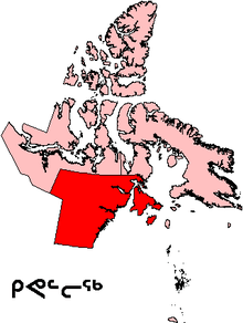
Kivalliq Region
The Kivalliq Region (/kɪˈvælɪk/; Inuktitut syllabics: ᑭᕙᓪᓕᖅ ) is an administrative region of Nunavut, Canada. It consists of the portion of the mainland to the west of Hudson Bay together with Southampton Island and Coats Island. The regional seat is Rankin Inlet. The population was 10,413 in the 2016 Census, an increase of 16.3% from the 2011 Census.[1]
Before 1999, Kivalliq Region existed under slightly different boundaries as Keewatin Region, Northwest Territories. Although the Kivalliq name became official in 1999, Statistics Canada has continued to refer to the area as Keewatin Region, Nunavut in publications such as the Census.[1] Most references to the area as "Keewatin" have generally been phased out by Nunavut-based bodies, as that name was originally rooted in a region of northwestern Ontario derived from a Cree dialect, and only saw application onto Inuit-inhabited lands because of the boundaries of the now-defunct District of Keewatin.
Geology
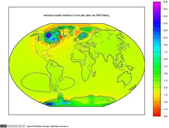
The Kivalliq Region is experiencing the world's highest rate of post-glacial rebound (as much as 17 mm (0.67 in) per year).
Communities
|
|
The remainder of the region is referred to as Keewatin, Unorganized by Statistics Canada.
Protected areas
- Arvia'juaq and Qikiqtaarjuk National Historic Site
- East Bay Migratory Bird Sanctuary
- Fall Caribou Crossing National Historic Site
- Harry Gibbons Migratory Bird Sanctuary
- Iqalugaarjuup Nunanga Territorial Park
- Inuujarvik Territorial Park
- McConnell River Migratory Bird Sanctuary
- Thelon Wildlife Sanctuary
Demographics
Canada 2016 Census[1]
- Population: 10,413
- Population change (2011–2016): +6.3%
- Private dwellings: 3,007
- Area: 444,621.71 km2 (171,669.40 sq mi)
- Density: 0.02/km2 (0.06/sq mi)
- National rank in terms of population (2011): 279th out of 283
- Territorial rank in terms of population: 2nd out of 3
References
- "Census Profile, 2016 Census Keewatin, Region". Statistics Canada. Retrieved March 5, 2017.
- "Census Profile, 2016 Census Arviat". Statistics Canada. Retrieved February 18, 2017.
- "Census Profile, 2016 Census Baker Lake". Statistics Canada. Retrieved February 18, 2017.
- "Census Profile, 2016 Census Chesterfield Inlet". Statistics Canada. Retrieved February 18, 2017.
- "Census Profile, 2016 Census Coral Harbour". Statistics Canada. Retrieved February 18, 2017.
- "Census Profile, 2016 Census Naujaat". Statistics Canada. Retrieved February 18, 2017.
- "Census Profile, 2016 Census Rankin Inlet". Statistics Canada. Retrieved February 18, 2017.
- "Census Profile, 2016 Census Whale Cove". Statistics Canada. Retrieved February 18, 2017.
Further reading
- Aldene Meis Mason, Leo Paul Dana, and Robert Brent Anderson, "Entrepreneurship in Coral Harbour, Nunavut" International Journal of Entrepreneurship and Innovation 9 (2), June 2008, pp. 1–10.
- Aldene Meis Mason, Leo Paul Dana, and Robert Brent Anderson, "A Study of Enterprise in Rankin Inlet, Nunavut: Where Subsistence Self-employment Meets Formal Entrepreneurship," International Journal of Entrepreneurship and Small Business 7 (1), January 2009, pp. 1–23.
- Aldene Meis Mason, Leo Paul Dana, Robert Brent Anderson, "The Inuit Commercial Caribou Harvest and Related Agri-Food Industries in Nunavut," International Journal of Entrepreneurship and Small Business 4 (6) 2007, pp. 785–806.
- Brown, Marc Allen. Towards Contextually Appropriate Planning Practice Evaluating the Role of Planning in the Kivalliq Community Planning Project. Ottawa: Library and Archives Canada = Bibliothèque et Archives Canada, 2005. ISBN 0-612-97034-5
- Dredge, L. A., and I. McMartin. Postglacial marine deposits and marine limit determinations, inner Wager Bay area, Kivalliq region, Nunavut. [Ottawa]: Geological Survey of Canada, 2005. ISBN 0-662-40388-6
- Loughery S, A Macaulay, M Fricke, A Durcan, and J Cooper. 2004. "Speech Language Pathology Services in Kivalliq Region of Nunavut, Canada". International Journal of Circumpolar Health. 63: 120–3.
- McMartin, I., and L. A. Dredge. History of ice flow in the Schultz Lake and Wager Bay areas, Kivalliq region, Nunavut. Ottawa, Ont: Geological Survey of Canada, 2005. ISBN 0-662-39974-9
- Upstairs Gallery (Winnipeg). Nunavut Celebrated Sculptures from Nunavut with Emphasis on Older Works from the Kivalliq (Keewatin) Region. Winnipeg: Upstairs Gallery, 1999.
External links
- Kivalliq Region information at Explore Nunavut
- kivalliq.com - photos, information, links from Rankin Inlet Nunavut
Places adjacent to Kivalliq Region | |
|---|---|
| Authority control |
|
|---|