Blenheim, New Zealand
Blenheim (/ˈblɛnɪm/ BLEN-im; Māori: Waiharakeke) is the most populous town in the region of Marlborough, in the north east of the South Island of New Zealand. It has an urban population of 26,400 (June 2019).[1] The surrounding Marlborough wine region is well known as the centre of the New Zealand wine industry. It enjoys one of New Zealand's sunniest climates, with warm, relatively dry summers and cool, crisp winters.
Blenheim | |
|---|---|
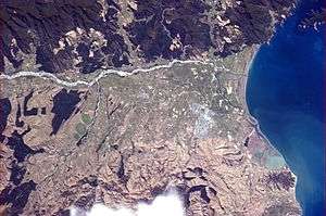 Blenheim pictured from the International Space Station (ISS) | |
 Blenheim | |
| Coordinates: 41.514°S 173.960°E | |
| Country | |
| Region | Marlborough |
| Territorial authority | Marlborough District |
| Named for | Battle of Blenheim |
| Member of Parliament | Stuart Smith, Kaikoura Electorate |
| Suburbs | List
|
| Government | |
| • Mayor | John Leggett |
| Area | |
| • Total | 103.89 km2 (40.11 sq mi) |
| Population (June 2019)[1] | |
| • Total | 26,400 |
| • Density | 250/km2 (660/sq mi) |
| Postcode | 7201 |
| Area code(s) | 03 |
Blenheim is named after the Battle of Blenheim (1704), where troops led by John Churchill, 1st Duke of Marlborough defeated a combined French and Bavarian force.
The New Zealand Ministry for Culture and Heritage gives a translation of "flax stream" for Waiharakeke.[2]
History

The sheltered coastal bays of Marlborough supported a small Māori population possibly as early as the 12th century. Archaeological evidence dates Polynesian human remains uncovered at Wairau Bar to the 13th century. The rich sea and bird life of the area would easily have supported such small communities. As the Māori population of the area increased, they developed the land to sustain the growing population. In the early 1700s canals and waterways were dug among the natural river courses, allowing for the first forms of farming in the area including that of fish and native water fowl. A total of approximately 18 km of channels are known to have been excavated before the arrival of European settlers. Māori in the Marlborough Region also cultivated crops, including kumara (sweet potato).
The area is also home to the first serious clash of arms between Māori and the British settlers after the signing of the Treaty of Waitangi. The Wairau Affray which occurred in what is now the village of Tuamarina.
The settlement was originally known to Europeans as The Beaver or Beaverton[3] due to its frequent flooding.[4]
Although the early history of Marlborough was closely associated with the Nelson settlement, the people of Marlborough desired independence from Nelson. In 1859, nineteen years after the original Nelson settlement, the request of Marlborough settlers was granted, and Marlborough became a separate province. Although gold was discovered in the province in the early 1860s the resulting boom did not last, and while the gold rush helped to expand the region, it was the development of pastoralism which provided the greatest long-term benefits. Marlborough squatters developed huge sheep runs that dominated the countryside, rivalling Canterbury's sheep stations in size and wealth.
Geography
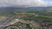
Situated on the Wairau Plain, the town is mostly flat with only its southern most fringe rising to the base of the Wither Hills. As the plain is surrounded by mountains on all but the eastern flank, which is open to Cook Strait, it is relatively well protected from the frequent southerly weather fronts occurring during winters. The area does however experience some high wind events during the course of the year, especially from the west where the wind is funneled down the Wairau Valley directly at the town. Open and exposed areas in and around Blenheim are also hit quite hard by winds blowing inland from Cook Strait. Blenheim sits at the confluence of the Taylor and Ōpaoa rivers. It is in a tectonically active zone and experiences several (usually small) earthquakes each year. The boundary between the Pacific plate (on which Blenheim sits) and the Indo-Australian plate passes just north of Blenheim.
Climate
The climate is generally very settled, largely due to the rainshadow effect of the mountain ranges to the west which shelter Blenheim from the heaviest of rains that hit the western part of the South Island.
Summers are typically warm and dry while winters are normally cool and frosty with clear sunny days that follow. Snowfall is rare as it is sheltered from cold southerly weather by the mountain ranges to the south.
Thunderstorms are an uncommon occurrence due to the sheltered climate. There is a higher likelihood in summer, when afternoon heating can generate a buildup of clouds above the ranges.
The highest recorded temperature is 37.8C, Recorded on 7 February 1973.[5] The lowest is −8.8C.
| Climate data for Blenheim (1981–2010) | |||||||||||||
|---|---|---|---|---|---|---|---|---|---|---|---|---|---|
| Month | Jan | Feb | Mar | Apr | May | Jun | Jul | Aug | Sep | Oct | Nov | Dec | Year |
| Average high °C (°F) | 24.1 (75.4) |
23.8 (74.8) |
21.9 (71.4) |
19.0 (66.2) |
16.0 (60.8) |
13.3 (55.9) |
12.6 (54.7) |
13.8 (56.8) |
15.8 (60.4) |
18.0 (64.4) |
20.0 (68.0) |
22.2 (72.0) |
18.4 (65.1) |
| Daily mean °C (°F) | 18.0 (64.4) |
17.6 (63.7) |
15.8 (60.4) |
13.0 (55.4) |
10.2 (50.4) |
7.7 (45.9) |
7.0 (44.6) |
8.2 (46.8) |
10.3 (50.5) |
12.2 (54.0) |
14.2 (57.6) |
16.5 (61.7) |
12.6 (54.7) |
| Average low °C (°F) | 11.8 (53.2) |
11.5 (52.7) |
9.8 (49.6) |
6.9 (44.4) |
4.5 (40.1) |
2.2 (36.0) |
1.5 (34.7) |
2.6 (36.7) |
4.7 (40.5) |
6.5 (43.7) |
8.4 (47.1) |
10.8 (51.4) |
6.8 (44.2) |
| Average precipitation mm (inches) | 48.9 (1.93) |
49.4 (1.94) |
46.5 (1.83) |
52.7 (2.07) |
60.6 (2.39) |
70.7 (2.78) |
74.3 (2.93) |
62.2 (2.45) |
65.2 (2.57) |
67.4 (2.65) |
55.0 (2.17) |
58.1 (2.29) |
711.0 (27.99) |
| Average precipitation days (≥ 1.0 mm) | 5.0 | 5.1 | 5.5 | 5.3 | 6.7 | 7.9 | 7.6 | 8.0 | 8.5 | 8.3 | 6.9 | 6.7 | 81.5 |
| Average relative humidity (%) | 68.7 | 74.2 | 74.9 | 77.5 | 81.5 | 82.3 | 83.7 | 80.8 | 73.3 | 72.1 | 67.7 | 67.5 | 75.4 |
| Mean monthly sunshine hours | 262.2 | 223.7 | 230.8 | 193.7 | 172.7 | 151.6 | 157.1 | 183.9 | 189.5 | 226.7 | 234.7 | 248.8 | 2,475.3 |
| Source: NIWA Climate Data[6] | |||||||||||||
Demographics
| Historical population | ||
|---|---|---|
| Year | Pop. | ±% p.a. |
| 1996 | 26,100 | — |
| 2001 | 27,300 | +0.90% |
| 2006 | 29,100 | +1.29% |
| 2013 | 30,100 | +0.48% |
| Source: [1] | ||
At the 2006 census, Blenheim had a population of 28,700, a change of 7.0% since the 2001 census. The June 2019 estimate puts Blenheim's population at 26,400.[1] Blenheim is New Zealand's 23rd largest urban area.
Age
- 21.3% of people were under 15, compared with 22.7% for New Zealand.
- 16.7% of people were 65 and over, compared with 12.1% for New Zealand.
Education
- 28.7% of people 15 and over had a post-secondary-school qualification, compared with 32% for New Zealand.
Ethnic background
Most residents are of European origin, predominantly of British, Irish, German and Dutch descent. Small Māori, Pacific Island and Asian communities exist. Ethnic diversity has increased in recent years with the arrival of large numbers of South Americans (mostly Brazilians) and Asians (mainly Indonesian, Japanese, Korean and Filipino), who work in the expanding viticulture sector.
The 2006 New Zealand census found that of people in the Blenheim Urban Area who completed the census forms:
Suburbs

|
|
Economy
The region's economy is rurally based with pastoral and horticultural farming providing a major source of income. The modern inhabitants, as their forebearers, continue to utilise the marine resources available. Lake Grassmere is the country's only salt works, producing 50% of its total salt requirement. Fishing and mussel farming are also extremely important in the region. Olive growing has also become popular in recent years.
Wine
Viticulture also has a very large impact on the local economy both directly, by way of employment and servicing required, and also by way of 'wine tourism'. The local cellars attracted hundreds of thousands of domestic and international tourists every year. The area also hosts the annual Marlborough Wine & Food Festival. The Marlborough wine region is now New Zealand's largest, and receives worldwide recognition for its Sauvignon Blanc wines.
With its growing international critical recognition, much of the Marlborough wine industry has come to be dominated by large firms, owned by major New Zealand companies or offshore investors. There are over 50 vineyards near Blenheim. Agricultural land prices in the Wairau Valley increased dramatically in the 1990s and 2000s.
Lifestyle
The sunny, pleasant climate has long attracted people to the region, as holiday-makers or as permanent settlers. The region is especially popular among retired people, as well as people seeking an alternative lifestyle. Rapid population growth and other factors though have led to a contemporary chronic shortage of affordable housing for low and middle income earners.
The Marlborough Region has a wide range of predominantly outdoor leisure activities and the relaxed lifestyle and the flourishing wine and gourmet food industry in Marlborough are enjoyed by both locals and visitors alike.
Events and points of interest

Omaka Aerodrome, south of the town centre, is the setting for the two-yearly Classic Fighters Marlborough airshow. With a large emphasis on aircraft of World War One, it has been held since 2001.
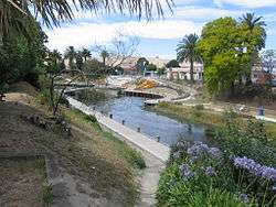
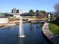
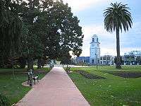
Seymour Square and Pollard Park are two of the town centres main attractions for walks and general tourism. Seymour Square is an open public area in the centre, containing the War Memorial and Clock Tower, unveiled in 1928, classified as a "Category I" ("places of 'special or outstanding historical or cultural heritage significance or value'") historic place by Heritage New Zealand.[7] The Square was named after Henry Seymour.[8] Pollard Park is a large public park including children's play areas, native shrubbery, rose gardens, a landscaped waterway, and is home to the Blenheim Golf Club and its 9-hole course, the Marlborough Tennis club and its courts, and Blenheim Croquet Club. They are dry and arid ranges which have previously been the site of severe grass fires.
The GCSB Waihopai communications monitoring facility, part of the ECHELON network, is near Blenheim.
Transportation
Air
Woodbourne Airport is a domestic airport and an RNZAF operational base. There are direct flights from Auckland and Wellington with Air New Zealand and from Wellington, Christchurch, and Paraparaumu with Sounds Air.[9]
Omaka Aerodrome, to the south of the town centre, is used solely by private and vintage aircraft. The Classic Fighters airshow (based mainly on World War I and II aircraft) is held biennially at Easter.
Road
State Highway 1 runs through Blenheim and State Highway 6 terminates at the junction of the two state highways. Blenheim is notable for a town of its size in that it does not have traffic lights at any intersection.[10] Instead, roundabouts speed arterial traffic flow. Since the installation of roundabouts traffic volumes have quickly increased and upgrading options are being considered, e.g. traffic lights, longer two-lane approaches and even a bypass.[11]
Rail
Blenheim is on the Main North Line, the northern part of the unofficially-named South Island Main Trunk Railway. The Coastal Pacific, the daily summer-only long-distance passenger train between Picton and Christchurch, stops at Blenheim Railway Station. The 1906 station has been listed NZHPT Category II since 1982.[12] It is a standard Vintage station, with Tudor half-timbering and tile.[13]
A major rail freight facility is north of Blenheim at Spring Creek.
The narrow-gauge Blenheim Riverside Railway runs through the town.
Media
Blenheim is served by a variety of print publications. The major daily newspaper serving the area is The Marlborough Express published by Fairfax NZ, with its headquarters in Blenheim. The Saturday Express and Midweek are community newspapers published by the same company and distributed throughout Marlborough. The Blenheim Sun is a twice-weekly free newspaper distributed each Wednesday and Friday.
- Radio
This is a list of FM radio stations in Blenheim. The town can also receive most AM and FM radio stations from Wellington, across Cook Strait; these are not included.
| FM Frequency | Nickname | Callsign | Format |
|---|---|---|---|
| 87.6 | Sunshine Radio | Easy Listening | |
| 88.0 | World FM | International/News | |
| 88.9 | Fresh FM Nelson | Alternative Community Radio | |
| 89.7 | The Breeze | Easy Listening (formerly known as Easy FM) | |
| 90.5 | ZM | Top 40 | |
| 91.3 | The Rock | Modern Rock | |
| 92.1 | Newstalk ZB | News/Talk | |
| 92.9 | MORE FM Marlborough | Adult Contemporary (formerly known as Sounds FM) | |
| 93.7 | Life FM | Christian/Alternative | |
| 94.5 | Radio Hauraki | Modern/Alternative Rock | |
| 95.3 | Radio Live | News/Talk | |
| 96.1 | The Sound | Classic Rock | |
| 96.9 | The Hits Marlborough | 2ZZE-FM | The Hits (formerly known as Radio Marlborough) |
| 98.5 | Radio Sport | Sports/Talk | |
| 99.3 | Radio New Zealand Concert | Classical | |
| 100.9 | Brian FM | Variety Hits | |
| 101.7 | Radio New Zealand National | Public Radio | |
| 104.1 | Rhema | Christian Music & Talk | |
| 104.9 | The Edge FM | Top 40 | |
| 105.7 | Magic | 50s, 60s, 70s | |
| 106.5 | Reelworld Radio | Pop Music | |
| 106.7 | Whisper FM | Nostalgia | |
Education
The first school opened in 1859. By 1875 there were three classes: Blenheim Upper Boys', Blenheim Lower Boys', and Blenheim Girls' and Infants'. Blenheim High School was formed within the school in 1879.[14]
Catholic schools for boys and girls were established in 1872, replaced by St Mary's Boys' school in 1886. In 1929 St Mary's was rebuilt after a fire.[15]
Marlborough High School, a coeducational secondary school, was founded in Blenheim in 1900. In 1919 it changed its name to Marlborough College. The intermediate section was split to form Bohally Intermediate in 1956. The college was split into separate boys' and girls' schools in 1963, with Marlborough Boys' College retaining the existing site and Marlborough Girls' College moving to a new site.[16]
There are currently 11 schools in the Blenheim urban area: [17]
- Blenheim School is a state contributing primary (Year 1-6) primary school. It has a roll of approximately 90.
- Bohally Intermediate is a state intermediate (Year 7–8) school opened in 1957 following a split from Marlborough College. It has a roll of approximately 526.
- Marlborough Boys' College is a state boys' secondary (Year 9–13) school. It opened in 1963 following the split of Marlborough College into separate boys' and girls schools, and has a roll of approximately 957.
- Marlborough Girls' College is a state girls' secondary (Year 9–13) school. It opened in 1963 following the split of Marlborough College into separate boys' and girls school, and has a roll of approximately 929.
- Mayfield School is a state contributing primary (Year 1-6) school in Mayfield. It has a roll of approximately 106.
- Redwoodtown School is a state full primary (Year 1-8) school in Redwoodtown. It has a roll of approximately 295.
- Richmond View School is a state-integrated Christian composite (Year 1-13) school in Redwoodtown. It has a roll of approximately 203.
- Springlands School is a state contributing primary (Year 1-6) school in Springlands. It has a roll of approximately 399.
- St Mary's School is a state-integrated Catholic full primary (Years 1-8) school. It has a roll of approximately 168.
- Whitney Street School is a state contributing primary (Year 1-6) primary school. It has a roll of approximately 350.
- Witherlea School is a state contributing primary (Year 1-6) primary school in Witherlea. It has a roll of approximately 357.
Other primary schools are in the surrounding localities of Renwick, Fairhall, Grovetown, Rapaura and Riverlands.
The Nelson Marlborough Institute of Technology has a campus in Blenheim.[18]
Infrastructure and services
Electricity
The Marlborough Electric Power Board (MEPB) was formed in October 1923 and established the Blenheim's first public supply in April 1927, following the commissioning of the Waihopai hydroelectric power station 40 km southwest of Blenheim. Two diesel generators were commissioned at Springlands in 1930 and 1937 to supplement the supply from Waihopai. The town was connected to Cobb Power Station in 1945,[19] which in turn was connected to the rest of the South Island grid in 1956. The diesel generators were relegated to standby duty, last generated power on 22 July 1992, and were decommissioned in 2003. The Energy Companies Act 1992 saw the MEPB corporatised and renamed Marlborough Electric. The 1998 electricity sector reforms required electricity companies to separate their lines and supply businesses. Marlborough Electric sold its generation and retailing business to Trustpower, with the remaining lines business renamed Marlborough Lines.[20]
Today, Marlborough Lines owns and operates the electricity distribution network servicing the city, with electricity fed from Transpower's national grid at its Blenheim substation in Springlands.
Notable people
- Greg Hegglun, cricketer
References
- Bibliography
- Reed, A. W. (2002). The Reed Dictionary of New Zealand Place Names. Auckland: Reed Books. ISBN 0-7900-0761-4.
- Notes
- "Subnational Population Estimates: At 30 June 2019". Statistics New Zealand. 22 October 2019. Retrieved 11 January 2020.
- "1000 Māori place names". New Zealand Ministry for Culture and Heritage. 6 August 2019.
- "Blenheim - NZHistory, New Zealand history online". web.archive.org. 12 February 2018.
- "Watery Marlborough settlement was never 'Beavertown'". Stuff.
- "Welcome to the Climate Database". cliflo.niwa.co.nz.
- "Climate Data and Activities". NIWA. Retrieved 19 October 2013.
- "War Memorial and Clock Tower". Register of Historic Places. Heritage New Zealand. Retrieved 21 December 2009.
- McLintock, Alexander Hare; Brian Newton Davis, M. A.; Taonga, New Zealand Ministry for Culture and Heritage Te Manatu. "BLENHEIM". An encyclopaedia of New Zealand, edited by A. H. McLintock, 1966.
- "Sounds Air – Routes". Retrieved 26 September 2016.
- Maria Slade (20 January 2016). "New Zealand's biggest town without traffic lights: Blenheim". Stuff.co.nz. Retrieved 28 May 2016.
- Selina Powell (25 May 2016). "New Zealand Transport Agency investigates State Highway 1 between Picton and Christchurch". Stuff.co.nz.
- "Search the List - Blenheim Railway Station - Heritage New Zealand". www.heritage.org.nz.
- "Rail Heritage Trust of New Zealand - Blenheim Station". www.railheritage.org.nz.
- McIntosh, Alister; Redman, William Edward; Allen, William Raymond, eds. (1940). Marlborough: A Provincial History. Blenheim: Marlborough Provincial Historical Committee. pp. 338–349.
- A. D. McIntosh, pp 328–329
- "Marlborough Boys' College – History".
- "New Zealand Schools Directory". New Zealand Ministry of Education. Retrieved 26 April 2020.
- "Marlborough Campus". Nelson Marlborough Institute of Technology. Archived from the original on 3 May 2008.
- "AtoJs Online — Appendix to the Journals of the House of Representatives — 1945 Session I — D-01 PUBLIC WORKS STATEMENT (BY THE HON. R. SEMPLE, MINISTER OF WORKS)". atojs.natlib.govt.nz. 1945. p. 11. Retrieved 7 April 2020.
- "The History of Marlborough Lines". www.marlboroughlines.co.nz.
External links
| Wikimedia Commons has media related to Blenheim, New Zealand. |
| Wikivoyage has a travel guide for Blenheim. |