Kabile Island
Kabile Island (Bulgarian: остров Кабиле, romanized: ostrov Kabile, IPA: [ˈɔstrof kɐbiˈlɛ]) is an Antarctic island extending 700 m (770 yd) in south-north direction and 450 m (490 yd) wide, situated off the north coast of Greenwich Island in the South Shetland Islands, Antarctica. It has a surface area of 19 hectares (47 acres).[1]
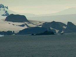 Kabile Island from English Strait, with Hrabar Nunatak, Greenwich Island and Sharp Peak, Livingston Island in the background | |
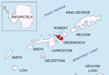 Location of Kabile Island | |
 Kabile Island Location of Kabile Island  Kabile Island Kabile Island (Antarctic Peninsula) | |
| Geography | |
|---|---|
| Location | Antarctica |
| Coordinates | 62°26′30″S 59°56′33″W |
| Archipelago | South Shetland Islands |
| Area | 19 ha (47 acres)[1] |
| Length | 0.7 km (0.43 mi) |
| Administration | |
| Administered under the Antarctic Treaty System | |
| Demographics | |
| Population | Uninhabited |
Named after the ancient Thracian town of Kabile near the present Bulgarian city of Yambol.[2]
Location
The island is located at 62°26′30″S 59°56′33″W which is 950 m (1,040 yd) east of Pavlikeni Point, 1 km (0.62 mi) north of Crutch Peaks, 200 m (220 yd) northwest of Miletich Point, and 2.5 km (1.6 mi) west-southwest of Ongley Island (Chilean mapping in 1966, British mapping in 1968 and Bulgarian in 2009).
See also
- Composite Antarctic Gazetteer
- List of Antarctic islands south of 60° S
- SCAR
- Territorial claims in Antarctica
Maps
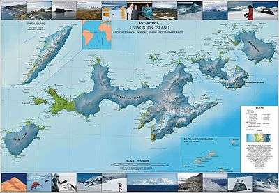
- L.L. Ivanov et al. Antarctica: Livingston Island and Greenwich Island, South Shetland Islands. Scale 1:100000 topographic map. Sofia: Antarctic Place-names Commission of Bulgaria, 2005
- L.L. Ivanov. Antarctica: Livingston Island and Greenwich, Robert, Snow and Smith Islands. Scale 1:120000 topographic map. Troyan: Manfred Wörner Foundation, 2009
- Antarctic Digital Database (ADD). Scale 1:250000 topographic map of Antarctica. Scientific Committee on Antarctic Research (SCAR). Since 1993, regularly upgraded and updated
Notes
- L.L. Ivanov. Antarctica: Livingston Island and Greenwich, Robert, Snow and Smith Islands. Scale 1:120000 topographic map. Troyan: Manfred Wörner Foundation, 2009. ISBN 978-954-92032-6-4
- SCAR Composite Antarctic Gazetteer: Kabile Island.
References
- Bulgarian Antarctic Gazetteer. Antarctic Place-names Commission. (details in Bulgarian, basic data in English)
External links
- Kabile Island. Copernix satellite image
This article includes information from the Antarctic Place-names Commission of Bulgaria which is used with permission.
| General |
| .svg.png) |
|---|---|---|
| Geographic regions | ||
| Waterways | ||
| Famous explorers | ||