Sail Rock (South Shetland Islands)
Sail Rock is the remaining uppermost part of a submerged volcanic edifice lying 7 nautical miles (13 km) southwest of Deception Island in the South Shetland Islands, Antarctica. It is 20 m long in southwest-northeast direction, 12 m wide and 30 m high. From a distance, the rock is reported to resemble a ship under sail, but at close range it is more like a house with a gable roof. The feature's name, which dates back to at least 1822, was probably given by sealers.
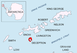
Location of Deception Island in the South Shetland Islands
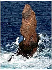
Sail rock

Fragment of George Powell's 1822 chart of the South Shetland Islands and South Orkney Islands featuring Sail Rock
Location
The rock is located at 63°2′56.5″S 60°57′32.4″W.
Maps
- Chart of South Shetland including Coronation Island, &c. from the exploration of the sloop Dove in the years 1821 and 1822 by George Powell Commander of the same. Scale ca. 1:200000. London: Laurie, 1822
- South Shetland Islands: Deception Island. Scale 1:50000 map. Insets: Sail Rock 1:10000. UK Antarctic Place-names Committee, 2010
- Antarctic Digital Database (ADD). Scale 1:250000 topographic map of Antarctica. Scientific Committee on Antarctic Research (SCAR). Since 1993, regularly updated
Notes
References
- Sail Rock. SCAR Composite Antarctic Gazetteer
- S. Kraus, A. Kurbatov and M. Yates. Geochemical signatures of tephras from Quaternary Antarctic Peninsula volcanoes. Andean Geology 40 (2013) 1. pp. 1-40
![]()
This article is issued from Wikipedia. The text is licensed under Creative Commons - Attribution - Sharealike. Additional terms may apply for the media files.