Robert Island
Robert Island or Mitchells Island or Polotsk Island or Roberts Island is an island 11 miles (18 km) long and 8 miles (13 km) wide, situated between Nelson Island and Greenwich Island in the South Shetland Islands, Antarctica. Robert Island is located at 62°24′S 59°30′W. Surface area 132 km2 (51 sq mi).[2] The name "Robert Island" dates back to around 1821 and is now established in international usage.
 Location of Robert Island in the South Shetland Islands | |
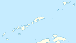 Robert Island Location of Robert Island  Robert Island Robert Island (Antarctica) | |
| Geography | |
|---|---|
| Location | Antarctica |
| Coordinates | 62°24′S 59°30′W |
| Archipelago | South Shetland Islands |
| Area | 132 km2 (51 sq mi) |
| Length | 11 mi (18 km) |
| Width | 8 mi (13 km) |
| Administration | |
| Administered under the Antarctic Treaty System | |
| Demographics | |
| Population | 0 |
 | |
 Edwards Point Lighthouse[1] Antarctica | |

| |
| Location | Edwards Point Robert Island South Shetland Islands Antarctica |
|---|---|
| Coordinates | 62°27′39″S 59°30′48″W |
| Year first constructed | n/a |
| Foundation | concrete base |
| Construction | fiber glass tower |
| Tower shape | cylindrical tower |
| Markings / pattern | yellow tower with orange horizontal bands[1] |
| Tower height | 7 metres (23 ft)[1] |
| Focal height | 25 metres (82 ft)[1] |
| Light source | solar power |
| Range | 7 nautical miles (13 km; 8.1 mi)[1] |
| Characteristic | Fl W 10s.[1] |
| Admiralty number | G1386[1] |
| NGA number | 2732[1] |
Much of the Coppermine Peninsula in the west of the island is made up by a perched strandflat surface that was in past at sea level.[3]
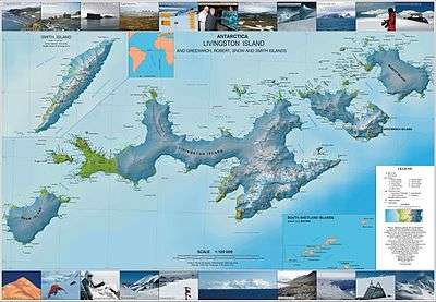
Topographic map of Livingston Island, Greenwich, Robert, Snow and Smith Islands
Captain Richard Fildes may have named Robert Island for his brig Robert.[4] Fildes was sealing in the South Shetlands in 1821–1822 until ice destroyed his vessel in March 1822. Fildes Strait is named for him.
See also
- List of lighthouses in Antarctica
- Composite Antarctic Gazetteer
- List of Antarctic and sub-Antarctic islands
- List of Antarctic islands south of 60° S
- SCAR
- Territorial claims in Antarctica
Maps
- Chart of South Shetland including Coronation Island, &c. from the exploration of the sloop Dove in the years 1821 and 1822 by George Powell Commander of the same. Scale ca. 1:200000. London: Laurie, 1822.
- South Shetland Islands. Scale 1:200000 topographic map. DOS 610 Sheet W 62 58. Tolworth, UK, 1968.
- L.L. Ivanov et al. Antarctica: Livingston Island and Greenwich Island, South Shetland Islands. Scale 1:100000 topographic map. Sofia: Antarctic Place-names Commission of Bulgaria, 2005.
- L.L. Ivanov. Antarctica: Livingston Island and Greenwich, Robert, Snow and Smith Islands. Scale 1:120000 topographic map. Troyan: Manfred Wörner Foundation, 2009. ISBN 978-954-92032-6-4
- Antarctic Digital Database (ADD). Scale 1:250000 topographic map of Antarctica. Scientific Committee on Antarctic Research (SCAR), 1993–2016.
References
- List of Lights, Pub. 111: The West Coasts of North and South America (Excluding Continental U.S.A. and Hawaii), Australia, Tasmania, New Zealand, and the Islands of the North and South Pacific Oceans (PDF). List of Lights. United States National Geospatial-Intelligence Agency. 2017.
- L.L. Ivanov. Antarctica: Livingston Island and Greenwich, Robert, Snow and Smith Islands. Scale 1:120000 topographic map. Troyan: Manfred Wörner Foundation, 2010. ISBN 978-954-92032-9-5 (First edition 2009. ISBN 978-954-92032-6-4)
- Serrano, Enrique; López-Martínez, Jerónimo (1997). "Geomorfología de la península Coppermine, isla Robert, islas Shetland del Sur, Antártica" (PDF). Serie Científica (in Spanish). INACh. 47: 19–29.
- Australian Antarctic Data Centre Gazeteer" Robert Island.
| General |
| .svg.png) |
|---|---|---|
| Geographic regions | ||
| Waterways | ||
| Famous explorers | ||
This article is issued from Wikipedia. The text is licensed under Creative Commons - Attribution - Sharealike. Additional terms may apply for the media files.