Research stations in Antarctica
A number of governments have set up permanent research stations in Antarctica and these bases are widely distributed. Unlike the drifting ice stations set up in the Arctic, the research stations of the Antarctic are constructed either on rock or on ice that is (for practical purposes) fixed in place.

Many of the stations are staffed around the year. A total of 42 countries (as of October 2006), all signatories to the Antarctic Treaty, operate seasonal (summer) and year-round research stations on the continent. The population of people performing and supporting scientific research on the continent and nearby islands varies from approximately 4,000 during the summer season to 1,000 during winter (June).[1] In addition to these permanent stations, approximately 30 field camps are established each summer to support specific projects.[2]
History
First bases

During the Heroic Age of Antarctic Exploration in the late 19th century, the first bases on the continent were established. In 1898, Carsten Borchgrevink, a Norwegian/British explorer, led the British Antarctic Expedition to Cape Adare, where he established the first Antarctic base on Ridley Beach. The expedition is often referred to now as the Southern Cross Expedition, after expedition ship name. Most of the staff were Norwegian, but the funds for the expedition were British, provided by Sir George Newnes. The 10 members of the expedition explored Robertson Bay to the west of Cape Adare by dog teams, and later, after being picked up by the ship at the base, went ashore on the Ross Ice Shelf for brief journeys. The expedition hut is still in good condition and visited frequently by tourists.
The hut was later occupied by Scott's Northern Party under the command of Victor Campbell for a year in 1911, after its attempt to explore the eastern end of the ice shelf discovered Roald Amundsen already ashore preparing for his assault on the South Pole.
In 1903, Dr William S. Bruce's Scottish National Antarctic Expedition set off to Antarctica, with one of its aims to establish a meteorological station in the area. After the expedition failed to find land, Bruce decided to head back to the Laurie Island in the South Orkneys and find an anchorage there.[3] The islands were well-situated as a site for a meteorological station, and their relative proximity to the South American mainland allowed a permanent station to be established.[4] Bruce instituted a comprehensive programme of work, involving meteorological readings, trawling for marine samples, botanical excursions, and the collection of biological and geological specimens.[3]
The major task completed during this time was the construction of a stone building, christened "Omond House".[5] This was to act as living accommodation for the parties that would remain on Laurie Island to operate the proposed meteorological laboratory. The building was constructed from local materials using the dry stone method, with a roof improvised from wood and canvas sheeting. The completed house was 20 feet by 20 feet square (6m × 6m), with two windows, fitted as quarters for six people. Rudmose Brown wrote: "Considering that we had no mortar and no masons' tools it is a wonderfully fine house and very lasting. I should think it will be standing a century hence ..."[6]
Bruce later offered to Argentina the transfer of the station and instruments on the condition that the government committed itself to the continuation of the scientific mission.[7] Bruce informed the British officer William Haggard of his intentions in December 1903, and Haggard ratified the terms of Bruce's proposition.[8]
The Scotia sailed back for Laurie Island on 14 January 1904 carrying on board Argentinean officials from the Ministry of Agriculture, National Meteorological Office, Ministry of Livestock and National Postal and Telegraphs Office. In 1906, Argentina communicated to the international community the establishment of a permanent base on the South Orkney Islands.
WWII and postwar expansion
Little happened for the following forty years until the Second World War, when the British launched Operation Tabarin in 1943, to establish a presence on the continent. The chief reason was to establish solid British claims to various uninhabited islands and parts of Antarctica, reinforced by Argentine sympathies toward Germany.

Prior to the start of the war, German aircraft had dropped markers with swastikas across Queen Maud Land in an attempt to create a territorial claim, see New Swabia.[9] Led by Lieutenant James Marr, the 14-strong team left the Falkland Islands in two ships, HMS William Scoresby (a minesweeping trawler) and Fitzroy, on Saturday January 29, 1944. Marr had accompanied the British explorer Sir Ernest Shackleton on his final Antarctic expedition in 1921 - 1922.
Bases were established during February near the abandoned Norwegian whaling station on Deception Island, where the Union Flag was hoisted in place of Argentine flags, and at Port Lockroy (on February 11) on the coast of Graham Land. A further base was founded at Hope Bay on February 13, 1945, after a failed attempt to unload stores on February 7, 1944. These bases were the first ever to be constructed on the mainland Antarctica.[10]
Operation provoked a massive expansion in international activity after the war. Chile organized its First Chilean Antarctic Expedition in 1947–48. Among other accomplishments, it brought the Chilean president Gabriel González Videla to personally inaugurate one of its bases, thereby becoming the first head of state to set foot on the continent.[11] Signy Research Station (UK) was established in 1947, Australia's Mawson Station in 1954, Dumont d'Urville Station was the first French station in 1956. In that same year, the United States built McMurdo Station and Amundsen–Scott South Pole Station, and the Soviet Union built Mirny Station.
List of research stations
The United States maintains the southernmost Base and the largest base and research station in Antarctica, Amundsen–Scott South Pole Station. The second-southernmost base is the Chinese Kunlun Station at 80°25′02″S during the summer season, and the Russian Vostok Station at 78°27′50″S during the winter season.
- * Observes daylight saving time.
List of Subantarctic research stations
- * Observes daylight saving time.
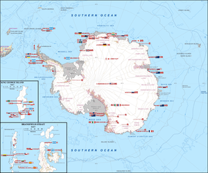
Map
This map shows permanent research stations only.

See also
| Wikimedia Commons has media related to Scientific stations in Antarctica. |
References
- Silja Vöneky; Sange Addison-Agyei (May 2011). "Oxford Public International Law". Max Planck Encyclopedia of Public International Law.
- 4.0 Antarctica - Past and Present
- Rudmose Brown, R. N.; Pirie, J. H.; Mossman, R. C. (2002). The Voyage of the Scotia. Edinburgh: Mercat Press. pp. 34–57. ISBN 1-84183-044-5.
- Rudmose Brown, p. 57.
- "Voyage of the Scotia 1902–04: The Antarctic". Glasgow Digital Library. Retrieved 2008-06-30.
- Speak, Peter (2003). William Speirs Bruce: Polar Explorer and Scottish Nationalist. Edinburgh: NMS Publishing. p. 85. ISBN 1-901663-71-X.
- Escude, Carlos; Cisneros, Andres. "Historia General de las Relaciones Exteriores de la Republica Argentina" (in Spanish). Archived from the original on May 4, 2012. Retrieved July 6, 2012.
- Moneta, Jose Manuel (1954). Cuatro Años en las Orcadas del Sur (9th ed.). Ediciones Peuser.
- "HMS Carnarvon Castle 1943".
- "Spirit of Scott 2012: Britain's polar interests lie under a cloud". The Daily Telegraph.
- Antarctica and the Arctic: the complete encyclopedia, Volume 1, by David McGonigal, Lynn Woodworth, page 98
- "New Zealand". Antarctic Treaty. Retrieved 25 September 2017.
- Antarctic Treaty
- "Dumont d'Urville". Institute Polaire Français. Retrieved 27 September 2017.
- "Fossil Bluff Station KG". British Antarctic Survey. Retrieved 12 August 2018.
- BAE Gabriel de Castilla Archived 2010-03-31 at the Wayback Machine
- "Giacomo Bove Station". Worldwide Antarctic Program. Retrieved 8 October 2018.
- Halley Research Station will not winter in 2018 British Antarctic Survey
- "Halley VI Antarctic Research Station". Archello.com.
- Halley Research Station relocation British Antarctic Survey
- "Archived copy". Archived from the original on 2014-05-12. Retrieved 2014-05-11.CS1 maint: archived copy as title (link)
- "Stazione Mario Zucchelli". Italiantartide. Retrieved 18 January 2020.
- "Current Local Time in Mario Zucchelli Station, Antarctica". timeanddate.com. Retrieved 20 May 2016.
- "Archived copy". Archived from the original on 2007-09-27. Retrieved 2006-03-19.CS1 maint: archived copy as title (link)
- Waking the Princess International Polar Foundation
- "Rothera Station R". British Antarctic Survey. Retrieved 12 August 2018.
- "French Polar Team - R1 Russkaya Station / Antarctica". Archived from the original on 2017-08-28. Retrieved 2011-10-04.
- "Signy Station H". British Antarctic Survey. Retrieved 12 August 2018.
- "Port Lockroy Diaries". United Kingdom Antarctic Heritage Trust. Retrieved 20 December 2018.
- "Deception Island Station B". British Antarctic Survey. Retrieved 28 November 2017.
- "Sandefjord Bay Station C". British Antarctic Survey. Retrieved 28 November 2017.
- "Hope Bay Station D". British Antarctic Survey. Retrieved 28 November 2017.
- "Stonington Island Station E". British Antarctic Survey. Retrieved 28 November 2017.
- "Faraday Station F". British Antarctic Survey. Retrieved 28 November 2017.
- "Admiralty Bay Station G". British Antarctic Survey. Retrieved 28 November 2017.
- "Prospect Point Station J". British Antarctic Survey. Retrieved 28 November 2017.
- "Anvers Island Station N". British Antarctic Survey. Retrieved 28 November 2017.
- "Danco Island Station O". British Antarctic Survey. Retrieved 28 November 2017.
- "Livingstone Island Station P". British Antarctic Survey. Retrieved 28 November 2017.
- "Adelaide Station T". British Antarctic Survey. Retrieved 28 November 2017.
- "View Point Station V". British Antarctic Survey. Retrieved 28 November 2017.
- "Detaille Island Station W". British Antarctic Survey. Retrieved 28 November 2017.
- "Horseshoe Island Station Y". British Antarctic Survey. Retrieved 28 November 2017.
- "中国正式建成南极泰山科考站".
- Varetto, Gianni (August 24, 2017). "Belarusian Antarctic Research Vechernyaya Station (WAP BLR-New)". Worldwide Antarctic Program.
- "Bird Island Station BI". British Antarctic Survey. Retrieved 12 August 2018.
- "King Edward Pont Station M". British Antarctic Survey. Retrieved 12 August 2018.
External links
- Research stations
- COMNAP Antarctic Facilities (Updated February 2014 - Excel File)
- COMNAP Antarctic Facilities Map (Archived September 15, 2009, at the Wayback Machine)
- Antarctic Exploration Timeline, animated map of Antarctic exploration and settlement, showing where and when Antarctic research stations were established
- Antarctic Digital Database Map Viewer SCAR
| General |
| .svg.png) |
|---|---|---|
| Geographic regions | ||
| Waterways | ||
| Famous explorers | ||