Javier, Leyte
Javier, officially the Municipality of Javier, is a 4th class municipality in the province of Leyte, Philippines. According to the 2015 census, it has a population of 25,379 people.[3]
Javier | |
|---|---|
| Municipality of Javier | |
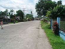
 Downtown area | |
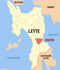 Map of Leyte with Javier highlighted | |

| |
.svg.png) Javier Location within the Philippines | |
| Coordinates: 10°48′N 124°56′E | |
| Country | |
| Region | Eastern Visayas (Region VIII) |
| Province | Leyte |
| District | 5th district of Leyte |
| Founded | June 1961 (as Bugho) |
| Renamed as Javier | December 1965 |
| Named for | Daniel F. Javier |
| Barangays | 28 (see Barangays) |
| Government | |
| • Type | Sangguniang Bayan |
| • Mayor | Michael Dragon T. Javier |
| • Vice Mayor | Emma M. Abueva |
| • Congressman | Carl Nicolas C. Cari |
| • Municipal Council | Councilors
|
| • Electorate | 17,949 voters (2019) |
| Area | |
| • Total | 152.70 km2 (58.96 sq mi) |
| Elevation | 35.9 m (117.8 ft) |
| Population (2015 census)[3] | |
| • Total | 25,379 |
| • Density | 170/km2 (430/sq mi) |
| • Households | 5,986 |
| Economy | |
| • Income class | 4th municipal income class |
| • Poverty incidence | 36.86% (2015)[4] |
| • Revenue (₱) | 79,859,964.18 (2016) |
| Time zone | UTC+8 (PST) |
| ZIP code | 6511 |
| PSGC | |
| IDD : area code | +63 (0)53 |
| Climate type | tropical rainforest climate |
| Native languages | Waray Tagalog |
| Website | www |
Geography
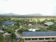
A rural town approximately 73 kilometres (45 mi) south of Tacloban City, Javiert is located between the boundaries of Baybay on the west side and MacArthur and Abuyog towns, along the Leyte Gulf. It has a very narrow coastlines and coastal plains facing the Pacific.[5]
Barangays
Javier is subdivided politically into 28 barangays [2] as per RA 3422 - An Act Creating the Municipality of Bugho as an independent municipality in the Province of Leyte, enacted on June 18, 1961.
- Abuyogay
- Batug
- Binulho
- Bonifacio (Pundok)
- Calzada
- Cancayang
- Caranhug
- Caraye
- Casulungan
- Comatin
- Guindapunan
- Inayupan
- Laray
- Magsaysay
- Malitbogay
- Manarug
- Manlilisid
- Naliwatan
- Odiong
- Picas Norte (Curba)
- Pinocawan
- Poblacion Zone 1
- Poblacion Zone 2
- Rizal
- Santa Cruz (Katun-an)
- Talisayan
- San Sotero (Tambis)
- Ulhay
Climate
| Climate data for Javier, Leyte | |||||||||||||
|---|---|---|---|---|---|---|---|---|---|---|---|---|---|
| Month | Jan | Feb | Mar | Apr | May | Jun | Jul | Aug | Sep | Oct | Nov | Dec | Year |
| Average high °C (°F) | 28 (82) |
28 (82) |
29 (84) |
30 (86) |
30 (86) |
29 (84) |
29 (84) |
29 (84) |
29 (84) |
29 (84) |
29 (84) |
28 (82) |
29 (84) |
| Average low °C (°F) | 22 (72) |
22 (72) |
22 (72) |
23 (73) |
24 (75) |
25 (77) |
25 (77) |
25 (77) |
25 (77) |
24 (75) |
24 (75) |
23 (73) |
24 (75) |
| Average precipitation mm (inches) | 78 (3.1) |
57 (2.2) |
84 (3.3) |
79 (3.1) |
118 (4.6) |
181 (7.1) |
178 (7.0) |
169 (6.7) |
172 (6.8) |
180 (7.1) |
174 (6.9) |
128 (5.0) |
1,598 (62.9) |
| Average rainy days | 16.7 | 13.8 | 17.3 | 18.5 | 23.2 | 26.5 | 27.1 | 26.0 | 26.4 | 27.5 | 24.6 | 21.0 | 268.6 |
| Source: Meteoblue [6] | |||||||||||||
History
The municipality of Javier, Leyte was formerly barrio Bugho of the municipality of Abuyog, Leyte. Bugho is a contraction of the dialect term "Binogho" (from local dialect root word "buho"), meaning a small clearing within a forest area. Settlers at about the turn of the century cultivated this small patch of land. Among the earliest known settlers was Macario Cultura, a native of Burauen, Leyte who is believed to have led his friends and relatives to farm the fertile soil of the area, then a virgin forest. Later, as the settlement grew, it became a sitio of barrio Pinocawan, and established barrio since the Spanish occupation.
Sometime in 1914, Daniel Falcon Javier of Consolacion, Sogod, Southern Leyte and a former teacher and principal of Cebu Normal School of Cebu City in the early 1900s came to explore the surrounding area of the new settlement. At that time he just came from Cabadbaran, Agusan del Norte where he started extensive farming activities since 1908 after his resignation as principal at the Cebu Normal School.
A malaria plague in Cabadbaran, however, inflicted a heavy death toll among his people so that he had to explore other suitable areas until he came upon Bugho. Impressed by the fertility of the soil, he started staking out his claims in Bugho and moved out from Cabadbaran completely. Subsequently, Daniel married Dolores Mercado Veloso, also of Consolacion, Sogod, Southern Leyte, and settled in Bugho naming his settlement as Camalig. He initiated projects in the community where he was readily accepted as the teacher, Daniel Javier's concern was to educate the people. He opened a school in 1918 on land donated by Pedro Abordo with Leona Valles as the first teacher. Daniel Javier was a dedicated man without vices and he led the people in community activities to improve their working habits, eradicate superstition that hampered progress and introduced the use of vaccines and medicines. He also prevailed upon the people to accept the modern and progressive ways of agriculture.
The community rapidly progressed as people from Cebu particularly from Argao and Bohol came in droves at the invitation and assistance of Mr. D.F. Javier who helped them legally acquire land-holdings. The people from Argao led by Pedro Gacera of Barrio Talaytay of that town settled at the west side of what is now Barrio Binulho.
A bigger school had to be built because of the size of the community and so Mano Daniel (as the people fondly called Daniel F. Javier) invited Mr. Waters, an American Superintendent to help them build one. Mr. Waters readily agreed and together with Evaresto Retucsan donated a new site for the school with the people contributing a counterpart of 1,000.00 Pesos with the release of 7,000.00 pesos from the government. The people through the "Bayanihan" system furnished most lumber requirements.
Corn, abaca & coconut were the main products of the community. Mano Daniel introduced irrigation utilizing the abundant water resources. It became a progressive community and was the center of trade among the neighboring barrios. In the 1939's it was among the contenders for township with barrios Palale and MacArthur. Since Mano Daniel's leadership was recognized by the provincial and district politicians, he used this influence to bring community improvements.
Bugho was not only among the centers of resistance activities but also as evacuation centers during the Second World War. Food and other resources continued to be readily available and the local people supported the guerrilla movement. After the war, guerrilla remnants turned into organized banditry as Bugho still the center of these activities. However, the people continued to work in their farms and production was boosted with the evacuees helping them.
Coconut, rice, abaca and ginger became the main products. Although organized banditry still existed and peace and order was not fully restored yet, the people were not deterred in their desire to become an independent municipality. During the mid-1950s, with the help of Attorney Higino A. Acala, Sr the "Bugho for Municipal Movement" was organized with Felomino Mercado, Pedro Gecera, Angel Caminong, Ambrocio Novio, Bernardino Tisado and Julia Brosas among its leaders. On December 18, 1959 at the initiative of Mayor Catalino Landia, the municipal council of Abuyog was convened to a session at Bugho endorsing by way of Resolution No. 7 to convert Bugho into an independent municipality of Abuyog to include the barrios of Caraya (Caraye), Ulhay, Tambis, Comatin, Caranhug, Talisayan and Manarug among many others.
House Bill No. 2895 sponsored by Congressman Veloso of the 3rd District of Leyte and co-sponsored by Speaker Daniel Z. Romualdez of the 1st district passed through the Senate and became Republic Act 3422 creating the municipality of Bugho in June 1961. The first Municipal election was on November 12, 1963 and on January 3, 1964, the following officials were elected: Ambrocio Novio - Mayor, Felimon Tano - Vice Mayor, Vicente Rellin, Ruperto de Luna, Ruperto Villamor, Hidulfo Malasaga, Pastor Dingal, Eutiquiano Badique as councilors. It began its operations as a 7th class municipality.

In December 1965, the municipal Council unanimously approved a resolution to change the name of the municipality of Bugho to Javier, in honor of the late Daniel Falcon Javier, who died in Consolacion, Sogod in 1957.
In 1970, the seat of government was finally transferred to the present site on a building constructed through the efforts of Congressman Artemio Mate.
In 1972, the son of the late Daniel F. Javier, Domingo V. Javier, was elected Mayor. Within a few months after his assumption of office and before Martial Law, road networks were vastly improved.
Thirty eight years later, the decades-old political leadership of the Cua's was challenged when businessman Leonardo "Sandy" Javier, Jr. ran as Mayor in 2010. His desire to “give back” blessings has pushed him to serve his hometown, concentrating his efforts on converting the poor municipality into a model town that would be emulated not only in the region but in the whole country. However, he was overwhelmingly victorious against his rival during the local election held that same year.
Demographics
| Population census of Javier | ||||||||||||||||||||||||||||||||||
|---|---|---|---|---|---|---|---|---|---|---|---|---|---|---|---|---|---|---|---|---|---|---|---|---|---|---|---|---|---|---|---|---|---|---|
|
| |||||||||||||||||||||||||||||||||
| Source: Philippine Statistics Authority [3][7][8][9] | ||||||||||||||||||||||||||||||||||
In the 2015 census, the population of Javier, Leyte, was 25,379 people,[3] with a density of 170 inhabitants per square kilometre or 440 inhabitants per square mile.
Language
Javier is a melting pot for both Waraynon and Cebuano speaking natives. But Lineyte-Samarnon ("waray-waray") is the official language spoken of the town.
Festival
The Karayhakan is held every third week of January.
Places of interest
Natural scenery:
- Black Sand Beach in Casulungan
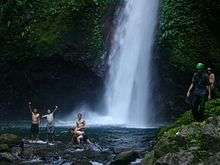
- Bito Falls in Caraye
- Buga in Caraye
- Circumferential Road
- Lake Bito
- Mat-i Falls
- Sangat in Odiong
- Binunggak Farm in Odiong Purok 3
- Overview at Guindapunan
Landmarks:
- East Visayan Adventist Academy Complex (EVAA)
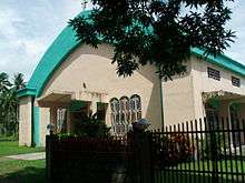
- New St. Micheal Parish Church
- Santo Niño Shrine
Education

Prep schools:
- Angelicum Catechetical School
- Day Care Centers
- Faith Baptist Learning Center
Primary schools:
- Javier Central School
- Manlilisid Central School
Secondary schools:
- Javier National High School (Main Campus)
- Manlilisid National High School
- Batug National High School- Javier Annex
- East Visayan Adventist Academy [San Sotero (Tambis)]
See also
- List of renamed cities and municipalities in the Philippines
References
- "Municipality". Quezon City, Philippines: Department of the Interior and Local Government. Retrieved 31 May 2013.
- "Province: Leyte". PSGC Interactive. Quezon City, Philippines: Philippine Statistics Authority. Retrieved 12 November 2016.
- Census of Population (2015). "Region VIII (Eastern Visayas)". Total Population by Province, City, Municipality and Barangay. PSA. Retrieved 20 June 2016.
- "PSA releases the 2015 Municipal and City Level Poverty Estimates". Quezon City, Philippines. Retrieved 12 October 2019.
- "Javier, Leyte". "https://latitude.to". Retrieved January 16, 2019.
- "Javier: Average Temperatures and Rainfall". Meteoblue. Retrieved 9 February 2020.
- Census of Population and Housing (2010). "Region VIII (Eastern Visayas)". Total Population by Province, City, Municipality and Barangay. NSO. Retrieved 29 June 2016.
- Censuses of Population (1903–2007). "Region VIII (Eastern Visayas)". Table 1. Population Enumerated in Various Censuses by Province/Highly Urbanized City: 1903 to 2007. NSO.
- "Province of Leyte". Municipality Population Data. Local Water Utilities Administration Research Division. Retrieved 17 December 2016.
External links
| Wikimedia Commons has media related to Javier, Leyte. |
- Javier Profile at PhilAtlas.com
- Javier Leyte' Official Website
- Philippine Census Information
- Local Governance Performance Management System
- nap.psa.gov.ph
Places adjacent to Javier, Leyte | ||||||||||
|---|---|---|---|---|---|---|---|---|---|---|
| ||||||||||
Tacloban (capital) | |
| Municipalities |
|
| Component city | |
| Independent component city |
|
| Highly urbanized city |
|
| Authority control |
|
|---|