Hilongos
Hilongos, officially the Municipality of Hilongos, is a 2nd class municipality in the province of Leyte, Philippines. According to the 2015 census, it has a population of 63,431 people.[3]
Hilongos | |
|---|---|
| Municipality of Hilongos | |
 Immaculate Conception Parish Church | |
 Seal | |
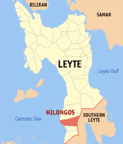 Map of Leyte with Hilongos highlighted | |
| |
.svg.png) Hilongos Location within the Philippines | |
| Coordinates: 10°22′N 124°45′E | |
| Country | |
| Region | Eastern Visayas (Region VIII) |
| Province | Leyte |
| District | 5th district of Leyte |
| Established as a town | 1737 |
| Barangays | 51 (see Barangays) |
| Government | |
| • Type | Sangguniang Bayan |
| • Mayor | Albert R. Villahermosa |
| • Vice Mayor | Manuel M. Gabisan |
| • Congressman | Carl Nicolas C. Cari |
| • Municipal Council | Councilors
|
| • Electorate | 41,892 voters (2019) |
| Area | |
| • Total | 192.92 km2 (74.49 sq mi) |
| Elevation | 7.4 m (24.3 ft) |
| Population (2015 census)[3] | |
| • Total | 63,431 |
| • Density | 330/km2 (850/sq mi) |
| • Households | 14,365 |
| Economy | |
| • Income class | 2nd municipal income class |
| • Poverty incidence | 33.87% (2015)[4] |
| • Revenue (₱) | 143,210,244.38 (2016) |
| Time zone | UTC+8 (PST) |
| ZIP code | 6524 |
| PSGC | |
| IDD : area code | +63 (0)53 |
| Climate type | tropical rainforest climate |
| Native languages | Cebuano Tagalog |
Hilongos is the biggest municipality in terms of income, population and land area in the southwestern part of Leyte (a string of five (5) equidistant municipalities namely, Inopacan, Hindang, Hilongos, Bato and Matalom comprises the southwestern part of Leyte). Hilongos is the center of government and ecclesiastical offices, shipping, rice production, trade, banking and finance, telecommunications, health facilities, education, sports and socio-cultural activities in this area.
The Port of Hilongos is one of the biggest and busiest in Region 8 (Eastern Visayas) and is well known for its good ferry and cargo services for Cebu City and vice versa. Due to its strategic location and proximity to the City of Cebu, Hilongos Port caters numerous day and night trips to and from Cebu City and is the primary choice for travelers in the area. Also, Hilongos is equipped with an airport, the Hilongos Airport in particular, which can be more helpful and useful if improved (travelers from the southern part of Leyte still needs to go to Tacloban or Cebu just to avail the services of commercial airlines). At present, Hilongos has two (2) public markets, the old one and the new one respectively. The Municipality of Hilongos is composed of fifty-one (51) barangays with vast coastal plains used mainly in the production of rice.
Geography
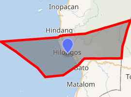
Hilongos shares its border with the Municipality of Hindang in the north, the Municipalities of Sogod (Southern Leyte) and Bontoc (Southern Leyte) in the east, the Municipality of Bato in the south and the Camotes Sea in the west.
Barangays
Hilongos comprises 51 barangays:[5]
- Agutayan
- Atabay
- Baas
- Bagong Lipunan (BLISS)
- Bagumbayan
- Baliw
- Bantigue
- Bon-ot
- Bung-aw
- Cacao
- Campina
- Cantandog 1
- Cantandog 2
- Concepcion (Makinhas)
- Hampangan
- Himo-aw
- Hitudpan
- Imelda Marcos (Pong-on)
- Kang-iras
- Kanghaas
- Lamak
- Libertad
- Liberty
- Lunang
- Magnangoy
- Manaul
- Marangog
- Matapay
- Naval
- Owak
- Pa-a
- Central Poblacion (Town Proper)
- Eastern Poblacion (Town Proper)
- Western Poblacion (Town Proper)
- Pontod
- Proteccion
- San Agustin
- San Antonio
- San Isidro
- San Juan
- San Roque (Taganas)
- Santa Cruz
- Santa Margarita
- Santo Niño
- Tabunok
- Tagnate
- Talisay
- Tambis
- Tejero
- Tuguipa
- Utanan
Climate
| Climate data for Abuyog, Leyte | |||||||||||||
|---|---|---|---|---|---|---|---|---|---|---|---|---|---|
| Month | Jan | Feb | Mar | Apr | May | Jun | Jul | Aug | Sep | Oct | Nov | Dec | Year |
| Average high °C (°F) | 28 (82) |
29 (84) |
29 (84) |
30 (86) |
30 (86) |
30 (86) |
29 (84) |
29 (84) |
29 (84) |
29 (84) |
29 (84) |
29 (84) |
29 (84) |
| Average low °C (°F) | 22 (72) |
22 (72) |
22 (72) |
23 (73) |
25 (77) |
25 (77) |
25 (77) |
25 (77) |
25 (77) |
24 (75) |
24 (75) |
23 (73) |
24 (75) |
| Average precipitation mm (inches) | 78 (3.1) |
57 (2.2) |
84 (3.3) |
79 (3.1) |
118 (4.6) |
181 (7.1) |
178 (7.0) |
169 (6.7) |
172 (6.8) |
180 (7.1) |
174 (6.9) |
128 (5.0) |
1,598 (62.9) |
| Average rainy days | 16.7 | 13.8 | 17.3 | 18.5 | 23.2 | 26.5 | 27.1 | 26.0 | 26.4 | 27.5 | 24.6 | 21.0 | 268.6 |
| Source: Meteoblue [6] | |||||||||||||
History

Lore has it that in the 12th century, Amahawin, an Ilonggo from Iloilo, conquered neighboring barangays on Leyte’s western shore and extended his territory to the present limits of Inopacan, Hindang, Bato, and Matalom. He formed a settlement and named it Hilongos, because its inhabitants were Ilonggos.
In 1710, the Jesuits created a residence there. In 1737, according to Redondo 1886:207, Hilongos was already a parish before this year. However, Braganza (1965) claims that Hilongos became a parish only in 1737. This date corresponded to the establishment of the town.(Tantuico 1964:41)
1754 was the date of the oldest parish books (deaths) as of 1884.
In 1768, the Jesuits ceded Hilongos to the Augustinians. In 1774–79, the Augustinians established schools in Hilongos. In 1784, Palompon, a Hilongos visita, became an independent parish.
In 1862, Manicar led a revolt at Barrio Santa Margarita.
In 1873, Leovio Magia led a revolt. Unlike the towns of eastern Leyte, which were ceded to the Franciscans in 1843, the towns along Leyte’s western coast fell one by one under the seculars.
In December 28, 2016, two explosions rocked the small town during the town fiesta. The explosion occurred in Barangay Central Poblacion were a boxing match was being held. At least 34 people residents were injured and brought to the Hilongos District Hospital and other nearby hospitals.[7] Officials said an IED was used in the attack. No suspects were identified.[8]
Demographics
| Population census of Hilongos | |||||||||||||||||||||||||||||||||||||||||||||||||
|---|---|---|---|---|---|---|---|---|---|---|---|---|---|---|---|---|---|---|---|---|---|---|---|---|---|---|---|---|---|---|---|---|---|---|---|---|---|---|---|---|---|---|---|---|---|---|---|---|---|
|
| ||||||||||||||||||||||||||||||||||||||||||||||||
| Source: Philippine Statistics Authority [3][9][10][11] | |||||||||||||||||||||||||||||||||||||||||||||||||
In the 2015 census, the population of Hilongos, Leyte, was 63,431 people,[3] with a density of 330 inhabitants per square kilometre or 850 inhabitants per square mile.
Heritage sites

Church complex—The present church’s bell tower is attributed by Redondo to a secular Don Leonardo Celis-Díaz, a native of Cebu. The building of the church fabric itself is disputed. Did Celis-Díaz build it or did he merely repair an older structure left by the Jesuits? Oral lore claims that the church and the ruined convento behind it are from the Jesuits; but Repetti reports otherwise. Certainly, there must have been some permanent structures when Hilongos became a residence.[12]
It is quite clear that the church complex underwent major renovations over the centuries. The original church, now incorporated as a transept, was a single-nave structure whose main door was also the gate to a bastioned fortification. Some bastions and walls of that fortification still remain. The main nave of the church is a modern construction, and the bell tower build by Fr. Celis-Diaz is an independent multi story structure, now plastered over with Portland cement.
The church interior is completely new in contrast to the convento which may have been completed in the 19th century. The convento guards many of the church’s antiques including silver vessels from the 18th century.
Transport facilities
Shipping
- Roble Shipping Inc.: Ro-Ro/Passenger/Cargo service, day & night trips to Cebu City and vice versa
- Gabisan Shipping Lines Inc.: Ro-Ro/Passenger/Cargo service, day & night trips to Cebu City and vice versa
- Leopards Motorboat Service: daily trips to Ubay, Bohol, and vice versa
- Also, different cargo vessels are making call at the port of Hilongos (mostly for copra and cement trade)
Land
- Main Type of Transportation: Bus/Mini-Bus/Van/Jeep/Multicab
- Route: Hilongos-Tacloban (vice versa), Hilongos-Ormoc/Baybay (vice versa), Hilongos-Maasin (vice versa)
- Other Types of Land Transport Facilities: Electronic Tricycles (RACAL), Sidecars (Tricycles), Trisikad or locally called as "Pot-pot" and also "Habal-habal" a motorcycle that is used as the mode of transport on the mountainous parts of Interior Hilongos.
Air
| Hilongos Airport | |
|---|---|
| Type of Airport | Emergency |
| Location | Eastern Poblacion, Hilongos, Leyte |
| Total Area | 17 hectares (42 acres) |
| Distance from Pob. | 1 kilometre (3,280 ft) |
| Airport Apron | 2,400 m2 (25,830 sq ft) MAC (Macadam) |
| Airport Runway | 1,000 m × 30 m (3,280 ft × 100 ft) (Macadam) |
| Airport Classification | Feeder |
Education
Tertiary
- MLG College of Learning (MLGCL)
- Virginia Institute of Technology (VIT)
Secondary
- Hilongos National Vocational School (HNVS)
- Saint Teresa School of Hilongos (STSH)
- Grelina Osmeña Christian College (GOCC)
- MLG College of Learning (MLGCL)
- Naval National High School
- Bung-aw National High School
- Santa Margarita National High School
- Concepcion National High School(CNHS)
- Hitudpan National High School
Elementary
- Hilongos South Central School (Hilongos South District)
- Lamak Central School (Hilongos North District)
- Saint Teresa School of Hilongos (STSH)
- Grelina Osmeña Christian College (GOCC)
- MLG College of Learning (MLGCL)
- Other Elementary and Primary Schools of the Hilongos North and South Districts respectively and other private Pre-Elementary institutions
See also
- 2016 Hilongos explosion
References
- "Municipality". Quezon City, Philippines: Department of the Interior and Local Government. Retrieved 31 May 2013.
- "Province: Leyte". PSGC Interactive. Quezon City, Philippines: Philippine Statistics Authority. Retrieved 12 November 2016.
- Census of Population (2015). "Region VIII (Eastern Visayas)". Total Population by Province, City, Municipality and Barangay. PSA. Retrieved 20 June 2016.
- "PSA releases the 2015 Municipal and City Level Poverty Estimates". Quezon City, Philippines. Retrieved 12 October 2019.
- Philippine Standard Geographic Code listing for Hilongos - National Statistical Coordination Board
- "Hilongos: Average Temperatures and Rainfall". Meteoblue. Retrieved 9 February 2020.
- http://cnnphilippines.com/regional/2016/12/29/Hilongos-Leyte-fiesta-blast.html
- http://cnnphilippines.com/regional/2016/12/29/Hilongos-Leyte-fiesta-blast.html
- Census of Population and Housing (2010). "Region VIII (Eastern Visayas)". Total Population by Province, City, Municipality and Barangay. NSO. Retrieved 29 June 2016.
- Censuses of Population (1903–2007). "Region VIII (Eastern Visayas)". Table 1. Population Enumerated in Various Censuses by Province/Highly Urbanized City: 1903 to 2007. NSO.
- "Province of Leyte". Municipality Population Data. Local Water Utilities Administration Research Division. Retrieved 17 December 2016.
- "Hilongos Fortification". muog.wordpress.com. Retrieved January 3, 2019.
- Braganza, José Vicente (1965). Story of Leyte. DWU (Divine Word University). Tacloban: unpublished.CS1 maint: ref=harv (link)
- Sendino y Redondo, Felipe (1886). Breve reseña de lo que fue y de lo que es la Diócesis de Cebú en las Islas Filipinas (in Spanish). Manila: Colegio de Santo Tomas.
- Tantuico, Francisco Sypaco (1964). Leyte : the historic islands. prefaced by Carlos P. Romulo. Tacloban: Leyte Pub. Corp.CS1 maint: ref=harv (link)
External links
| Wikimedia Commons has media related to Hilongos, Leyte. |
Places adjacent to Hilongos | ||||||||||
|---|---|---|---|---|---|---|---|---|---|---|
| ||||||||||
Tacloban (capital) | |
| Municipalities |
|
| Component city | |
| Independent component city |
|
| Highly urbanized city |
|