MacArthur, Leyte
MacArthur, officially the Municipality of MacArthur, is a 5th class municipality in the province of Leyte, Philippines. According to the 2015 census, it has a population of 21,211 people.[3]
MacArthur | |
|---|---|
| Municipality of MacArthur | |
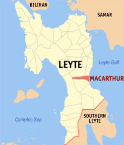 Map of Leyte with MacArthur highlighted | |
| |
.svg.png) MacArthur Location within the Philippines | |
| Coordinates: 10°51′N 124°57′E | |
| Country | |
| Region | Eastern Visayas (Region VIII) |
| Province | Leyte |
| District | 2nd district of Leyte |
| Named for | Douglas MacArthur |
| Barangays | 31 (see Barangays) |
| Government | |
| • Type | Sangguniang Bayan |
| • Mayor | Rudin T. Babante |
| • Vice Mayor | Rene R. Leria |
| • Congressman | Lolita T. Javier |
| • Municipal Council | Councilors
|
| • Electorate | 14,752 voters (2019) |
| Area | |
| • Total | 57.57 km2 (22.23 sq mi) |
| Elevation | 6.0 m (19.7 ft) |
| Population (2015 census)[3] | |
| • Total | 21,211 |
| • Density | 370/km2 (950/sq mi) |
| • Households | 5,077 |
| Economy | |
| • Income class | 5th municipal income class |
| • Poverty incidence | 36.34% (2015)[4] |
| • Revenue (₱) | 64,651,768.02 (2016) |
| Time zone | UTC+8 (PST) |
| ZIP code | 6509 |
| PSGC | |
| IDD : area code | +63 (0)53 |
| Climate type | tropical rainforest climate |
| Native languages | Waray Tagalog |
| Website | www |
Barangays
MacArthur is politically subdivided into 31 barangays. [2]
- Batug
- Burabod
- Capudlosan
- Casuntingan
- Causwagan
- Danao
- General Luna
- Kiling
- Lanawan
- Liwayway
- Maya
- Oguisan
- Osmeña
- Palale 1
- Palale 2
- Poblacion District 1
- Poblacion District 2
- Poblacion District 3
- Pongon
- Quezon
- Romualdez
- Salvacion
- San Antonio
- San Isidro
- San Pedro
- San Vicente
- Santa Isabel
- Tin-awan
- Tuyo
- Doña Josefa
- Villa Imelda
Climate
| Climate data for MacArthur, Leyte | |||||||||||||
|---|---|---|---|---|---|---|---|---|---|---|---|---|---|
| Month | Jan | Feb | Mar | Apr | May | Jun | Jul | Aug | Sep | Oct | Nov | Dec | Year |
| Average high °C (°F) | 28 (82) |
29 (84) |
29 (84) |
30 (86) |
30 (86) |
30 (86) |
29 (84) |
29 (84) |
29 (84) |
29 (84) |
29 (84) |
29 (84) |
29 (84) |
| Average low °C (°F) | 22 (72) |
22 (72) |
22 (72) |
23 (73) |
25 (77) |
25 (77) |
25 (77) |
25 (77) |
25 (77) |
24 (75) |
24 (75) |
23 (73) |
24 (75) |
| Average precipitation mm (inches) | 78 (3.1) |
57 (2.2) |
84 (3.3) |
79 (3.1) |
118 (4.6) |
181 (7.1) |
178 (7.0) |
169 (6.7) |
172 (6.8) |
180 (7.1) |
174 (6.9) |
128 (5.0) |
1,598 (62.9) |
| Average rainy days | 16.7 | 13.8 | 17.3 | 18.5 | 23.2 | 26.5 | 27.1 | 26.0 | 26.4 | 27.5 | 24.6 | 21.0 | 268.6 |
| Source: Meteoblue [5] | |||||||||||||
Demographics
| Population census of MacArthur | |||||||||||||||||||||||||||||||||||||
|---|---|---|---|---|---|---|---|---|---|---|---|---|---|---|---|---|---|---|---|---|---|---|---|---|---|---|---|---|---|---|---|---|---|---|---|---|---|
|
| ||||||||||||||||||||||||||||||||||||
| Source: Philippine Statistics Authority [3][6][7][8] | |||||||||||||||||||||||||||||||||||||
In the 2015 census, the population of MacArthur, Leyte, was 21,211 people,[3] with a density of 370 inhabitants per square kilometre or 960 inhabitants per square mile.
References
- "Municipality". Quezon City, Philippines: Department of the Interior and Local Government. Retrieved 31 May 2013.
- "Province: Leyte". PSGC Interactive. Quezon City, Philippines: Philippine Statistics Authority. Retrieved 12 November 2016.
- Census of Population (2015). "Region VIII (Eastern Visayas)". Total Population by Province, City, Municipality and Barangay. PSA. Retrieved 20 June 2016.
- "PSA releases the 2015 Municipal and City Level Poverty Estimates". Quezon City, Philippines. Retrieved 12 October 2019.
- "MacArthur: Average Temperatures and Rainfall". Meteoblue. Retrieved 29 February 2020.
- Census of Population and Housing (2010). "Region VIII (Eastern Visayas)". Total Population by Province, City, Municipality and Barangay. NSO. Retrieved 29 June 2016.
- Censuses of Population (1903–2007). "Region VIII (Eastern Visayas)". Table 1. Population Enumerated in Various Censuses by Province/Highly Urbanized City: 1903 to 2007. NSO.
- "Province of Leyte". Municipality Population Data. Local Water Utilities Administration Research Division. Retrieved 17 December 2016.
External links
- MacArthur Profile at PhilAtlas.com
- Philippine Standard Geographic Code
- Philippine Census Information
- Local Governance Performance Management System
Places adjacent to MacArthur, Leyte | ||||||||||
|---|---|---|---|---|---|---|---|---|---|---|
| ||||||||||
Tacloban (capital) | |
| Municipalities |
|
| Component city | |
| Independent component city |
|
| Highly urbanized city |
|
This article is issued from Wikipedia. The text is licensed under Creative Commons - Attribution - Sharealike. Additional terms may apply for the media files.