Inopacan, Leyte
Inopacan, officially the Municipality of Inopacan, is a 4th class municipality in the province of Leyte, Philippines. According to the 2015 census, it has a population of 20,550 people.[3]
Inopacan | |
|---|---|
| Municipality of Inopacan | |
 Sunset at Cuatro Islas | |
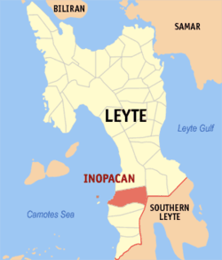 Map of Leyte with Inopacan highlighted | |
| |
.svg.png) Inopacan Location within the Philippines | |
| Coordinates: 10°30′N 124°45′E | |
| Country | |
| Region | Eastern Visayas (Region VIII) |
| Province | Leyte |
| District | 5th district of Leyte |
| Barangays | 20 (see Barangays) |
| Government | |
| • Type | Sangguniang Bayan |
| • Mayor | Azucena P. Mirambel |
| • Vice Mayor | Lourdes B. Villas |
| • Congressman | Carl Nicolas C. Cari |
| • Municipal Council | Councilors
|
| • Electorate | 14,985 voters (2019) |
| Area | |
| • Total | 94.62 km2 (36.53 sq mi) |
| Elevation | 8.8 m (28.9 ft) |
| Population (2015 census)[3] | |
| • Total | 20,550 |
| • Density | 220/km2 (560/sq mi) |
| • Households | 4,900 |
| Economy | |
| • Income class | 4th municipal income class |
| • Poverty incidence | 35.36% (2015)[4] |
| • Revenue (₱) | 71,083,452.69 (2016) |
| Time zone | UTC+8 (PST) |
| ZIP code | 6522 |
| PSGC | |
| IDD : area code | +63 (0)53 |
| Climate type | tropical rainforest climate |
| Native languages | Cebuano Tagalog |
| Website | www |
Etymology
The name of the town is a namesake of a legendary winged hero named by the natives as “Inong pak-an”, according to old folks. But history tells that Inopacan is a new name of Canamocan which was a pre-Spanish settlement according to Lee W. Vance in his book, Tracing our Ancestor and the analytical understanding of the written manuscripts of the Jesuit missionaries in Leyte. However, it remains unaccepted despite that Canamocan was mentioned as now 'Inopacan' by some authors like Atty. Francisco Tantuico of the history of Baybay, Locsin on Ormoc's History, and Eduardo Makabenta Sr. on Carigara's history.
Geography
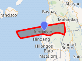
In the south, Inopacan borders with the town of Hindang and Camotes Sea in the west.[5]
Apid and Mahaba Islands, part of the Cuatro Islas, are within the administrative jurisdiction of the municipality of Inopacan.
Barangays
Inopacan is politically subdivided into 20 barangays.
- Apid
- Cabulisan
- Caminto
- Can-angay
- Caulisihan
- Conalum
- De los Santos (Mahilum)
- Esperanza
- Guadalupe
- Guinsanga-an
- Hinabay
- Jubasan
- Linao
- Macagoco
- Maljo
- Marao
- Poblacion
- Tahud
- Taotaon
- Tinago
Climate
| Climate data for Inopacan, Leyte | |||||||||||||
|---|---|---|---|---|---|---|---|---|---|---|---|---|---|
| Month | Jan | Feb | Mar | Apr | May | Jun | Jul | Aug | Sep | Oct | Nov | Dec | Year |
| Average high °C (°F) | 28 (82) |
29 (84) |
29 (84) |
30 (86) |
30 (86) |
30 (86) |
29 (84) |
29 (84) |
29 (84) |
29 (84) |
29 (84) |
29 (84) |
29 (84) |
| Average low °C (°F) | 22 (72) |
22 (72) |
22 (72) |
23 (73) |
25 (77) |
25 (77) |
25 (77) |
25 (77) |
25 (77) |
24 (75) |
24 (75) |
23 (73) |
24 (75) |
| Average precipitation mm (inches) | 78 (3.1) |
57 (2.2) |
84 (3.3) |
79 (3.1) |
118 (4.6) |
181 (7.1) |
178 (7.0) |
169 (6.7) |
172 (6.8) |
180 (7.1) |
174 (6.9) |
128 (5.0) |
1,598 (62.9) |
| Average rainy days | 16.7 | 13.8 | 17.3 | 18.5 | 23.2 | 26.5 | 27.1 | 26.0 | 26.4 | 27.5 | 24.6 | 21.0 | 268.6 |
| Source: Meteoblue [6] | |||||||||||||
History
Much of the documents that could be a good source for learning about the history of Inopacan were destroyed when the town hall as well as the parish church and its convent were leveled into rubbles as the Japanese war planes bombed these buildings during the World War II. But based on the account of Inopacnon elders and records from neighboring towns, Inopacan was once a barangay of Hindang. with Fernando Polistico (a Boholano) as the first appointed Capitan del Barrio, and was succeeded by Francisco Espinoza, and lastly by Agustín Kudéra before Inopacan became a town on December 6, 1892.[7]
Demographics
| Population census of Inopacan | |||||||||||||||||||||||||||||||||||||||||||||||||
|---|---|---|---|---|---|---|---|---|---|---|---|---|---|---|---|---|---|---|---|---|---|---|---|---|---|---|---|---|---|---|---|---|---|---|---|---|---|---|---|---|---|---|---|---|---|---|---|---|---|
|
| ||||||||||||||||||||||||||||||||||||||||||||||||
| Source: Philippine Statistics Authority [3][8][9][10] | |||||||||||||||||||||||||||||||||||||||||||||||||
In the 2015 census, the population of Inopacan, Leyte, was 20,550 people,[3] with a density of 220 inhabitants per square kilometre or 570 inhabitants per square mile.
References
- "Municipality". Quezon City, Philippines: Department of the Interior and Local Government. Retrieved 31 May 2013.
- "Province: Leyte". PSGC Interactive. Quezon City, Philippines: Philippine Statistics Authority. Retrieved 12 November 2016.
- Census of Population (2015). "Region VIII (Eastern Visayas)". Total Population by Province, City, Municipality and Barangay. PSA. Retrieved 20 June 2016.
- "PSA releases the 2015 Municipal and City Level Poverty Estimates". Quezon City, Philippines. Retrieved 12 October 2019.
- "Cuatro Islas: The 4 Gems of Inopacan". www.choosephilippines.com. Retrieved January 9, 2019.
- "Inopacan: Average Temperatures and Rainfall". Meteoblue. Retrieved 9 February 2020.
- Inopacan Leyte and the Inopacnons by Edgie Polistico, see this link: http://inopacan.blogspot.com/2010/03/history-of-inopacan-in-my-years-of.html
- Census of Population and Housing (2010). "Region VIII (Eastern Visayas)". Total Population by Province, City, Municipality and Barangay. NSO. Retrieved 29 June 2016.
- Censuses of Population (1903–2007). "Region VIII (Eastern Visayas)". Table 1. Population Enumerated in Various Censuses by Province/Highly Urbanized City: 1903 to 2007. NSO.
- "Province of Leyte". Municipality Population Data. Local Water Utilities Administration Research Division. Retrieved 17 December 2016.
External links
| Wikivoyage has a travel guide for Inopacan. |
- Inopacan Official Website
- Inopacan Profile at PhilAtlas.com
- Philippine Standard Geographic Code
- Philippine Census Information
- Local Governance Performance Management System
Places adjacent to Inopacan, Leyte | ||||||||||
|---|---|---|---|---|---|---|---|---|---|---|
| ||||||||||
Tacloban (capital) | |
| Municipalities |
|
| Component city | |
| Independent component city |
|
| Highly urbanized city |
|