Interstate 840 (Tennessee)
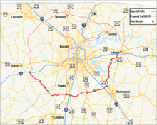
Interstate 840 (I-840), formerly State Route 840 (SR 840), also designated as Tennessee National Guard Parkway,[3] is a freeway that serves as an outer bypass route around Nashville, Tennessee, built by the Tennessee Department of Transportation (TDOT). At a length of 77.28 miles (124.37 km) long, it is the tenth-longest auxiliary Interstate Highway in the nation.[4] The route serves the cities of Lebanon, Murfreesboro, Franklin, and Dickson, all suburbs of Nashville.[5][6]
| ||||
|---|---|---|---|---|
| Tennessee National Guard Parkway | ||||
%26groups%3D_096a4d612f6825b80804f522726c2bf33e4de8f2.svg)
I-840 highlighted in red | ||||
| Route information | ||||
| Auxiliary route of I-40 | ||||
| Maintained by TDOT | ||||
| Length | 77.28 mi[1] (124.37 km) | |||
| Existed | August 12, 2016[2]–present | |||
| Major junctions | ||||
| West end | ||||
| ||||
| East end | ||||
| Location | ||||
| Counties | Dickson, Hickman, Williamson, Rutherford, Wilson | |||
| Highway system | ||||
| ||||

First proposed by former Governor Lamar Alexander as part of a system of Bicentennial Parkways, construction began in 1991 and was completed in 2012. I-840 was originally planned as an Interstate Highway, but was constructed entirely with state funds, and as a result was initially designated as a state route.[3] In 2015, approval was given by the Federal Highway Administration (FHWA) and the American Association of State Highway and Transportation Officials (AASHTO) to redesignate SR 840 as I-840 as part of its integration into the Interstate Highway System. On August 12, 2016, TDOT announced that the route had officially been renamed Interstate 840, and that re-signing work would begin.[2]
Route description
I-840 begins at an interchange in Dickson County near Dickson. It initially runs southeast through a predominantly hilly terrain, and crosses briefly into Hickman County about five miles (8.0 km) later. The route remains in Hickman County for less than 1 1⁄2 miles (2.4 km), before crossing into Williamson County, and reaching an interchange with State Route 100 (SR 100) about one mile (1.6 km) later. I-840 continues through a predominantly rural area, characterized by rolling hills with moderate grades, and reaches SR 46 at an interchange near the community of Leiper's Fork about seven miles (11 km) later. About three miles (4.8 km) later, I-840 crosses the Natchez Trace Parkway and turns east. I-840 has an interchange with U.S. Route 31 (US 31) about 15 miles (24 km) later, and about two miles (3.2 km) beyond this point is an interchange with US 431. Less than one mile (1.6 km) later, I-840 comes to an interchange with I-65 south of Franklin in an interchange that resembles a cloverstack interchange, containing two loop ramps and two underpass ramps that cross I-840 combined together. The route continues through a hilly terrain with several steep grades, and crosses the Harpeth River about eight miles (13 km) later. Three miles (4.8 km) later I-840 comes to an interchange with US 31A and US 41A near the community of Triune. About three miles (4.8 km) later I-840 crosses SR 96 at the top of a large hill, and begins a steep downgrade, with the westbound lanes utilizing a truck climbing lane over a short distance and crossing into Rutherford County. About eight miles (13 km) later, I-840 comes to an interchange with I-24 northwest of Murfreesboro. This interchange is almost a complete cloverleaf, containing three loop ramps and one flyover. The route then turns northeast, passing through a relatively flat region, and interchanges with US 41 and US 70S in a cloverstack interchange about two miles (3.2 km) later. About 3⁄4 mile (1.2 km) later, I-840 crosses the west fork of the Stones River, and about five miles (8.0 km) later, crosses the east fork of the Stones River. About 3 miles (4.8 km) later, the route crosses the Fall Creek impoundment of the J. Percy Priest Lake, and a short distance later is an interchange with the western terminus of SR 452 (Bill France Boulevard). I-840 then crosses into Wilson County less than 1 mile (1.6 km) later, and has an interchange with SR 109 about six miles (9.7 km) beyond this point. The route then turns slightly northeast, and about 3.8 miles (6.1 km) later reaches its eastern terminus with I-40 west of Lebanon.[7][8]
History
| |
|---|---|
| Location | Dickson–Lebanon |
| Length | 77.28 mi[1] (124.37 km) |
| Existed | 1991–2016 |
In 1975 the Tennessee Highway System Plan issued by TDOT for the next four years first identified the need for an outer beltway around Nashville within the next 20 years.[9] The I-840 project was initiated in 1986 with the passage of the Better Roads Program by the Tennessee General Assembly.[10] This program, which had been proposed and spearheaded by then-governor Lamar Alexander, increased the state's gasoline and diesel taxes to fund six new freeway projects and a backlog of 15 projects that had been labeled as urgent needs, as well as other projects.[11] I-840 was the largest of these six freeway projects, dubbed "Bicentennial Parkways", and was initially expected to cost $351 million (equivalent to $696 million in 2018[12]).[10] While initially referred to as I-840 in the state plan,[10] the highway was constructed entirely with state transportation funds and was officially designated as a state route.[13] The 1986–1987 state budget contained the initial funding for the project.[3] The alignment for the first section was announced in December 1988,[3] and survey and design work began the following year.[14] The first contract for construction was signed in 1991, and work progressed in stages.[3]
The first section of I-840, between I-40 in Lebanon and Stewart's Ferry Pike, opened on August 2, 1995.[15] The extension to I-24 near Murfreesboro was completed on November 21, 1996,[16] and the section between I-24 and US 31A/US 41A near Triune was completed on November 30, 2000.[17] The portion between US 31A/US 41A and US 431 (Lewisburg Pike) near Franklin, including the interchange with I-65, opened on October 18, 2001.[18] The section between I-40 near Dickson and SR 100 opened on December 5, 2002.[19] Due to high costs and environmental concerns, the proposed northern half of I-840 was indefinitely placed on hold in 2003.[3] As work moved into Williamson County, residents filed complaints and eventually lawsuits in an effort to have TDOT address both environmental and aesthetic issues, considerably slowing work in that county.[13] As a result, TDOT chose to slightly modify the design and employ new construction methods.[3] The section between US 31 (Columbia Pike) and US 431 opened to traffic on September 9, 2005.[20] Construction resumed in July 2007, with work beginning on the segment between SR 100 and SR 46, and this segment opened on October 27, 2010.[21] The contract for the segment between Leiper's Creek Road and US 31 was awarded in December 2008,[22] and on February 19, 2010, TDOT awarded the final construction contract for I-840, the segment between SR 46 and Leiper's Creek Road.[23] These two segments, the final 14.2 miles (22.9 km) of SR 840, were opened on November 2, 2012.[3] The project took 26 years to complete at a cost of $753.4 million (equivalent to $832 million in 2018[12]) .[13]
Northern loop
TDOT was first authorized to begin studies for a northern loop of I-840 north of Nashville and past Dickson, Clarksville, Springfield, and Gallatin by the state legislature in 1993.[1] Environmental studies began in 1994 and a draft environmental impact statement (DEIS) was released in 1995.[9] Many residents in the predominantly rural and agricultural areas where the route was to pass were initially opposed.[9] Plans were later abandoned and the General Assembly ordered TDOT to discontinue further studies and planning of that highway because of state budget problems. An entire circular loop would possibly be about 178 miles (286 km) long, ranging from 86 to 116 miles (138 to 187 km). Other important objections against additional extensions of the I-840 highway include the hilly nature of the terrain north of Nashville (the Highland Rim), which would require huge and costly amounts of excavation, soil relocation, and bridge construction. In October 2003, TDOT placed the northern loop plan on indefinite hold, citing a lack of documented transportation needs and lack of participation from local politicians.[1] The western terminus of I-840 was actually constructed in anticipation of the northern segment, and as a result, contains a very short unused extension.[7]
Redesignation
In 2015, TDOT submitted a request to AASHTO to redesignate SR 840 as I-840. Though the application had an error that required TDOT to refile it, AASHTO conditionally approved it and submitted it to the FHWA for their approval.[24][25] FHWA approved the change on July 22, 2015, and AASHTO finalized their approval on September 25, 2015.[26] TDOT announced on August 12, 2016 that it would start replacing the signs to change over the designation the week of August 14, and that the project would be completed by the end of the year at a cost of $230,000 (equivalent to $240,000 in 2018[12]).[2]
Exit list
| County | Location | mi[6] | km | Exit | Destinations | Notes | ||
|---|---|---|---|---|---|---|---|---|
| Dickson | | 0.0 | 0.0 | 1 | Signed as exits 1A (west) and 1B (east) westbound; I-40 exit 176; stub road westbound | |||
| Hickman |
No major junctions | |||||||
| Williamson | | 7.3 | 11.7 | 7 | ||||
| 14.1 | 22.7 | 14 | ||||||
| Burwood | 22.9 | 36.9 | 23 | |||||
| Thompson's Station | 28.3 | 45.5 | 28 | |||||
| 30.3 | 48.8 | 30 | ||||||
| 31.1 | 50.1 | 31 | Signed as exits 31A (south) and 31B (north); I-65 exit 59 | |||||
| Peytonsville | 34.9 | 56.2 | 34 | Peytonsville–Trinity Road | ||||
| | 37.1 | 59.7 | 37 | Arno Road | ||||
| Triune | 41.9 | 67.4 | 42 | |||||
| Rutherford | Almaville | 46.9 | 75.5 | 47 | ||||
| Blackman | 50.8 | 81.8 | 50 | Veterans Parkway – Blackman | ||||
| Murfreesboro | 53.1 | 85.5 | 53 | Signed as exits 53A (east) and 53B (west) westbound; I-24 exit 74 | ||||
| 55.1 | 88.7 | 55 | Signed as exits 55A (south/east) and 55B (north/west) | |||||
| | 57.8 | 93.0 | 57 | Sulphur Springs Road | ||||
| 61.4 | 98.8 | 61 | ||||||
| 65.2 | 104.9 | 65 | ||||||
| Wilson | | 67.2 | 108.1 | 67 | Couchville Pike | Exit to Cedars of Lebanon State Park | ||
| Gladeville | 70.6 | 113.6 | 70 | Stewarts Ferry Pike – Gladeville | ||||
| | 72.0 | 115.9 | 72 | Signed as 72A (east) and 72B (west) eastbound | ||||
| Lebanon | 76.8 | 123.6 | 76 | Signed as exits 76A (east) and left 76B (west); I-40 exit 235; | ||||
| 1.000 mi = 1.609 km; 1.000 km = 0.621 mi | ||||||||
See also

References
- Tennessee Department of Transportation (October 31, 2003). "TDOT Announces Decision on State Route 840 North" (PDF) (Press release). Tennessee Department of Transportation. Archived from the original (PDF) on November 27, 2007. Retrieved July 17, 2007.
- Tennessee Department of Transportation (August 12, 2016). "Tennessee Adds New 77 Miles of Highway to Interstate System: State Route 840 Now Designated as Interstate 840" (Press release). Nashville: Tennessee Department of Transportation. Retrieved August 12, 2016.
- Tennessee Department of Transportation (2012). State Route 840: Enjoy the Ride (PDF) (Dedication program). Tennessee Department of Transportation. Archived from the original (PDF) on November 19, 2012. Retrieved June 12, 2015.
- Adderly, Kevin (December 31, 2015). "Table 2: Auxiliary Routes of the Dwight D. Eisenhower National System of Interstate and Defense Highways as of December 31, 2015". Route Log and Finder List. Federal Highway Administration. Retrieved February 6, 2016.
- Tennessee Department of Transportation (2014). Tennessee: 2014 Official Transportation Map (Map). c. 1:633,600. Nashville: Tennessee Department of Transportation. §§ C7–B8.
- Google (June 20, 2015). "State Route 840" (Map). Google Maps. Google. Retrieved June 20, 2015.
- Google (December 18, 2017). "I-840" (Map). Google Maps. Google. Retrieved December 18, 2017.
- 2020 Official Transportation Map (PDF) (Map). Nashville, Tennessee: Tennessee Department of Transportation. 2020. Retrieved May 18, 2020.
- Tennessee Department of Transportation (1995). Proposed Route 840 North from Interstate 65 to Interstate 40 West of Nashville in Robertson, Cheatham, Dickson, and Montgomery Counties, Tennessee. Vol. 2. Nashville: Tennessee Department of Transportation. FHWA-TN-ESI-9501-D. Retrieved December 18, 2017 – via Google Books.
- Henry, Douglas; Darnell, Riley; Bragg, John; Robinson, C. Robb (April 1, 1986). 1986 Road Program (PDF) (Report). Tennessee Department of Transportation. Retrieved April 26, 2020.
- Tennessee Department of Transportation (2014). "Brief History of TDOT" (PDF). Tennessee Department of Transportation. Retrieved April 28, 2020.
- Thomas, Ryland; Williamson, Samuel H. (2019). "What Was the U.S. GDP Then?". MeasuringWorth. Retrieved April 6, 2019. United States Gross Domestic Product deflator figures follow the Measuring Worth series.
- Anderson, Skip (November 5, 2012). "State Route 840 Opening Ends Arduous, Laborious and Costly Project". The City Paper. Nashville. Archived from the original on June 24, 2013. Retrieved June 11, 2015.
- Tennessee Department of Transportation (n.d.). "SR 840 South: Brief History". Tennessee Department of Transportation. Archived from the original on July 14, 2007.
- Margulies, Ellen (August 2, 1995). "Motorists ease onto new highway". The Tennessean. Nashville. p. 4. Retrieved April 19, 2020.
- Tennessee Department of Transportation (November 18, 1996). "Future I-840 Opens from Lebanon to Murfreesboro" (Press release). Nashville: Tennessee Department of Transportation. Archived from the original on July 23, 1997. Retrieved March 31, 2020.
- Tennessee Department of Transportation (November 28, 2000). "Twelve New Miles of State Route 840 Opens" (Press release). Nashville: Tennessee Department of Transportation. Archived from the original on June 19, 2002. Retrieved March 26, 2020.
- Tennessee Department of Transportation (October 18, 2001). "840 Opens Connecting Lebanon, Murfreesboro and Franklin" (Press release). Nashville: Tennessee Department of Transportation. Archived from the original on June 6, 2002. Retrieved March 26, 2020.
- "State Route 840 from Dickson to Fairview Open on Thursday" (Press release). Nashville, Tennessee: Tennessee Department of Transportation. December 3, 2002. Archived from the original on July 15, 2003. Retrieved May 18, 2020.
- Tennessee Department of Transportation (September 9, 2005). "New Section of State Route 840 Opens to Traffic" (Press release). Nashville: Tennessee Department of Transportation. Archived from the original on January 25, 2007. Retrieved March 26, 2020.
- Oaks, Julie (October 27, 2010). "Governor Bredesen Opens New Section of State Route 840" (Press release). Nashville: Tennessee Department of Transportation. Archived from the original on April 16, 2013. Retrieved April 12, 2019.
- Lovely, Lori (May 4, 2010). "Rounding Off SR 840 Circle Around Nashville". Construction Equipment Guide. Retrieved April 12, 2019.
- "TDOT Awards Contract on Final State Route 840 Project" (Press release). Nashville, Tennessee: Tennessee Department of Transportation. February 24, 2010. Retrieved May 15, 2020.
- Special Committee on U.S. Route Numbering (May 14, 2015). "Special Committee on U.S. Route Numbering Spring 2015 Report to the Standing Committee on Highways" (PDF) (Report). Washington, DC: American Association of State Highway and Transportation Officials. p. 6. Archived (PDF) from the original on June 3, 2019. Retrieved June 6, 2015.
- Wright, Bud (June 4, 2015). "Interstate Applications for I-840 TN" (PDF). Letter to Greg Nadeau. Washington, DC: American Association of State Highway and Transportation Officials. Retrieved June 6, 2015.
- Special Committee on U.S. Route Numbering (September 25, 2015). "Special Committee on U.S. Route Numbering Report to the Standing Committee on Highways" (PDF) (Report). Washington, DC: American Association of State Highway and Transportation Officials. p. 1. Archived (PDF) from the original on August 20, 2018. Retrieved December 18, 2015.
External links
| Wikimedia Commons has media related to Interstate 840 (Tennessee). |
- Interstate 840 at Kurumi.com
- Interstate 840 at Interstate-Guide.com