Hut Point Peninsula
Hut Point Peninsula (77°47′S 166°51′E) is a long, narrow peninsula from 3 to 5 km (2 to 3 mi) wide and 24 km (15 mi) long, projecting south-west from the slopes of Mount Erebus on Ross Island, Antarctica. McMurdo Station (US) and Scott Base (NZ) are Antarctic research stations located on the Hut Point Peninsula.

Antarctica
History
The British National Antarctic Expedition (1901–04) under Robert Falcon Scott built its hut on Hut Point, a small point lying 1.5 km (1 mi) north-east of Cape Armitage, the southern headland of the peninsula. Members of the British Antarctic Expedition, 1910–13 (BAE), under Scott, wintering on Cape Evans and often using the hut during their journeys, came to refer to the whole peninsula as the Hut Point Peninsula.[1][2]
Historic sites and monuments
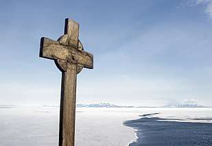
Several features on Hut Point, including the cross memorial for George Vince and the store hut for the Scott expeditions, are protected under the Antarctic Treaty.[2] Both the cross (HSM 19) and the hut (HSM 18) have been designated Historic Sites or Monuments, following proposals by New Zealand and the United Kingdom to the Antarctic Treaty Consultative Meeting.[3] The point is protected as Antarctic Specially Protected Area (ASPA) No.158 largely because of its historic significance as one of the principal sites of early human activity in Antarctica.[4]
Geography
A number of features on Hut Point Peninsula have been charted and named by various Antarctic expeditions.
On the west coast, south of the Erebus Ice Tongue, is Descent Cliff, charted and named by BAE members because they descended to the sea ice from it.[5] South of that are the Hutton Cliffs, named by the Discovery Expedition (DE) of 1901–04 for Captain Hutton of the Canterbury Museum, Christchurch, New Zealand.[6] To the south is Rodgers Point, named in 2000 by the New Zealand Geographic Board after Thelma Rodgers, the first woman to winter at Scott Base.[7] 2.5 nmi (4.6 km; 2.9 mi) south is Knob Point, a rounded coastal point. This name was adopted by the United States Advisory Committee on Antarctic Names (US-ACAN) as it was already in use by fieldworkers in the area.[7][8] Just south is Danger Slopes, a steep ice slope terminating west in a sheer drop to Erebus Bay. It was named by DE personnel because Seaman George T. Vince of the expedition lost his life here in a blizzard when he slipped and fell into the sea.[9] The southernmost point of the peninsula is Cape Armitage, named by Scott's expedition for Lieutenant (later Captain) Albert B. Armitage, second in command and navigator on the Discovery.[10]
On the east coast, Pram Point sits about 1.5 nmi (2.8 km; 1.7 mi) northeast of Cape Armitage. It was discovered by DE personnel, and named because they kept a Norwegian 'pram' (dinghy) there to get to the Ross Ice Shelf during the summer months.[11] New Zealand Antarctic Scott Base is on Pram Point. North of Pram Point is ice-covered Polar Bear Point. The name, given by US-ACAN, is allusive; when viewed from the west, the appearance of the point is suggestive of the head, neck, and fore part of a polar bear.[12] Farther north is Ackley Point, named by US-ACAN for sea ice specialist Stephen F. Ackley.[13] Approximately 5.4 nmi (10.0 km; 6.2 mi) north of that is a rock spur called Sultans Head Rock, named by DE personnel.[14] 3.2 nmi (5.9 km; 3.7 mi) northeast of that is a headland called Tyree Head, named for U.S. Navy Admiral David Tyree. The headland rises to over 400 m (1,300 ft) and is ice-covered except for rock exposed on the lower east side.[15]
Geology
Hut Point Peninsula consists of a series of basaltic scoria cones, craters and domes that were formed in the last 1.34 million years. Named cones, domes, and craters on the peninsula include:[16]
Cones, domes, and other protrusions
- Black Knob
- Boulder Cones
- Breached Cone
- Castle Rock
- Centipede Nunatak
- Cone Hill
- Crater Hill
- Ford Rock
- Fortress Rocks
- Observation Hill
- Sulfur Cones
References
- "Hut Point Peninsula". Geographic Names Information System. United States Geological Survey. Retrieved 2012-07-05.
- Stonehouse, Bernard. Encyclopedia of Antarctica and the Southern Oceans, John Wiley and Sons, 2002. ISBN 0-471-98665-8
- "List of Historic Sites and Monuments approved by the ATCM (2012)" (PDF). Antarctic Treaty Secretariat. 2012. Retrieved 2013-10-27.
- "Hut Point, Ross Island" (PDF). Management Plan for Antarctic Specially Protected Area No. 158: Measure 2, Annex K. Antarctic Treaty Secretariat. 2005. Archived from the original (PDF) on 2012-01-21. Retrieved 2013-06-12.
- "Descent Cliff". Geographic Names Information System. United States Geological Survey. Retrieved 25 January 2020.
- "Hutton Cliffs". Geographic Names Information System. United States Geological Survey. Retrieved 25 January 2020.
- "Rodgers Point". Geographic Names Information System. United States Geological Survey. Retrieved 25 January 2020.
- "Knob Point". Geographic Names Information System. United States Geological Survey. Retrieved 25 January 2020.
- "Danger Slopes". Geographic Names Information System. United States Geological Survey. Retrieved 25 January 2020.
- "Cape Armitage". Geographic Names Information System. United States Geological Survey. Retrieved 25 January 2020.
- "Pram Point". Geographic Names Information System. United States Geological Survey. Retrieved 25 January 2020.
- "Polar Bear Point". Geographic Names Information System. United States Geological Survey. Retrieved 25 January 2020.
- "Ackley Point". Geographic Names Information System. United States Geological Survey. Retrieved 25 January 2020.
- "Sultans Head Rock". Geographic Names Information System. United States Geological Survey. Retrieved 25 January 2020.
- "Tyree head". Geographic Names Information System. United States Geological Survey. Retrieved 25 January 2020.
- "Hut Point Peninsula". Global Volcanism Program. Smithsonian Institution. Retrieved 2018-01-18.

| General |
| .svg.png) |
|---|---|---|
| Geographic regions | ||
| Waterways | ||
| Famous explorers | ||