Enderby Land
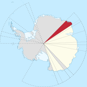
Enderby Land is a projecting land mass of Antarctica. Its shore extends from Shinnan Glacier at about 67°55′S 44°38′E to William Scoresby Bay at 67°24′S 59°34′E, approximately 1⁄24 of the earth's longitude. It was first documented in western and eastern literature in February 1831 by John Biscoe aboard the whaling brig Tula, and named after the Enderby Brothers of London, the ship's owners who encouraged their captains to combine exploration with sealing.[1]
Coasts and mountain ranges
Coastal features include Amundsen Bay, Casey Bay and Cape Monakov. Mountain ranges or sub-ranges being crests above pack ice (escarpments), are the Scott Mountains, the Tula Mountains, and the Napier Mountains. The highest peak is Mount Elkins at 2,300 metres (7,500 ft) Above Ordnance Datum (conventional sea level).
Nation state claims
Subject to the constraints of the Antarctic Treaty System, the longest-held nation-state claimant rights in the territory is Australia, being a large part of its claimed Australian Antarctic Territory up to various high latitudes towards the South Pole.
See also
References
- "Enderby Land". Geographic Names Information System. United States Geological Survey. Retrieved 2012-03-01.
![]()
External links
| Wikimedia Commons has media related to Enderby Land. |
- Australian Antarctic Gazetteer
- United States Geological Survey, Geographic Names Information System (GNIS)
- Scientific Committee on Antarctic Research (SCAR)
- PDF Map of the Australian Antarctic Territory
| Authority control |
|
|---|