Mount Terra Nova
Mount Terra Nova is a snow-covered mountain, 2,130 m (6,990 ft),[1] between Mount Erebus and Mount Terror on Ross Island. It was first mapped by the Discovery expedition in 1901–04, and named for Terra Nova, the relief ship for this expedition and the British Antarctic Expedition, 1910–13.[1]
| Mount Terra Nova | |
|---|---|
 Mount Terra Nova | |
| Highest point | |
| Elevation | 2,130 m (6,990 ft) [1] |
| Coordinates | 77°31′S 167°57′E |
| Geography | |
| Location | Ross Island, Antarctica |
| Geology | |
| Age of rock | 820,000-1.75 million years |
| Mountain type | Shield volcano (extinct) |
Terra Nova Saddle (77°31′S 167°37′E) is one of three prominent snow saddles on Ross Island, this one at c. 1,400 m (4,600 ft) between Mount Erebus and Mount Terra Nova. It is named in association with Mount Terra Nova, which rises to 2,130 m (6,990 ft) to the east of this saddle.
Terra Nova Glacier (77°27′S 167°42′E) is a glacier about 5 nautical miles (9 km) long in north–central Ross Island. It flows north from the saddle between Mount Erebus and Mount Terra Nova into Lewis Bay. It is so named for its proximity to Mount Terra Nova.
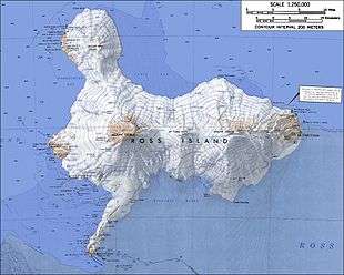
Mount Terra Nova is in the middle.
Mount Terror is in the right.
Mount Erebus is in the lower left.
Mount Bird is in the upper left.
See also
References
| Wikimedia Commons has media related to Mount Terra Nova. |
- "Terra Nova, Mount". Geographic Names Information System. United States Geological Survey. Retrieved 2012-08-08.
![]()
![]()