Showa Station (Antarctica)
Showa Station (Japanese: 昭和基地, Hepburn: Shōwa Kichi), sometimes alternately spelled Syowa Station,[1] is a Japanese permanent research station on East Ongul Island in Queen Maud Land, Antarctica. Built in 1957, Showa Station is named for the era in the Japanese calendar during which it was established, the Shōwa period.
Showa 昭和基地 | |
|---|---|
| Shōwa Kichi | |
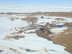 Aerial photograph of Showa Station, December 2018. | |
 Showa Location of Showa Station in Antarctica | |
| Coordinates: 69°00′16″S 39°34′54″E | |
| Country | |
| Location in Antarctica | East Ongul Island Queen Maud Land Antarctica |
| Administered by | Japanese Antarctic Program |
| Established | 1957 |
| Elevation | 29 m (95 ft) |
| Population | |
| • Total |
|
| Time zone | UTC+3 (SYOT) |
| Type | All-year round |
| Period | Annual |
| Status | Operational |
| Facilities | 60 separate buildings |
| Website | National Institute of Polar Research |
Overview
Showa Station serves as a research outpost for astronomy, meteorology, biology and earth sciences. It comprises over 60 separate buildings, large and small, including a 3-storey administration building, living quarters, power plant, sewage treatment facility, environmental science building, observatory, data processing facility, satellite building, ionospheric station, incinerator, earth science building, and radiosonde station. Also present are fuel tanks, water storage, solar panels, a heliport, water retention dam, and radio transmitter.
Historic monument
A cairn and plaque at the station commemorate Shin Fukushima, a member of the 4th Japanese Antarctic Research Expedition, who died in October 1960 while carrying out his duties. The cairn, which contains some of his ashes, was erected on 11 January 1961 by his colleagues. It has been designated a Historic Site or Monument (HSM 2) following a proposal by Japan to the Antarctic Treaty Consultative Meeting.[2]
Climate
The climate is classified as an Ice cap climate (Köppen: EF), since there are no months where the average temperature exceeds 0.0 °C (32.0 °F).
| Climate data for Showa Station, elevation: 18 m or 59 ft, 1981–2010 normals, extremes 1957-2011 | |||||||||||||
|---|---|---|---|---|---|---|---|---|---|---|---|---|---|
| Month | Jan | Feb | Mar | Apr | May | Jun | Jul | Aug | Sep | Oct | Nov | Dec | Year |
| Record high °C (°F) | 12.0 (53.6) |
8.0 (46.4) |
22.0 (71.6) |
6.6 (43.9) |
9.0 (48.2) |
−0.7 (30.7) |
0.0 (32.0) |
0.9 (33.6) |
1.0 (33.8) |
8.0 (46.4) |
7.3 (45.1) |
20.0 (68.0) |
22.0 (71.6) |
| Average high °C (°F) | 2.0 (35.6) |
−0.5 (31.1) |
−4.3 (24.3) |
−7.6 (18.3) |
−10.7 (12.7) |
−12.1 (10.2) |
−14.1 (6.6) |
−15.8 (3.6) |
−14.9 (5.2) |
−10.8 (12.6) |
−4.0 (24.8) |
1.1 (34.0) |
−7.6 (18.3) |
| Daily mean °C (°F) | −0.7 (30.7) |
−2.9 (26.8) |
−6.5 (20.3) |
−10.1 (13.8) |
−13.5 (7.7) |
−15.2 (4.6) |
−17.3 (0.9) |
−19.4 (−2.9) |
−18.1 (−0.6) |
−13.5 (7.7) |
−6.8 (19.8) |
−1.6 (29.1) |
−10.5 (13.1) |
| Average low °C (°F) | −3.7 (25.3) |
−5.5 (22.1) |
−9.2 (15.4) |
−13.0 (8.6) |
−16.6 (2.1) |
−18.7 (−1.7) |
−20.8 (−5.4) |
−23.3 (−9.9) |
−22.0 (−7.6) |
−17.2 (1.0) |
−10.4 (13.3) |
−4.6 (23.7) |
−13.8 (7.2) |
| Record low °C (°F) | −20.0 (−4.0) |
−23.0 (−9.4) |
−25.0 (−13.0) |
−35.9 (−32.6) |
−38.5 (−37.3) |
−44.1 (−47.4) |
−42.7 (−44.9) |
−41.4 (−42.5) |
−45.3 (−49.5) |
−38.0 (−36.4) |
−26.0 (−14.8) |
−23.0 (−9.4) |
−45.3 (−49.5) |
| Average rainfall mm (inches) | 0.0 (0.0) |
0.0 (0.0) |
0.0 (0.0) |
0.0 (0.0) |
0.0 (0.0) |
0.0 (0.0) |
0.0 (0.0) |
0.6 (0.02) |
0.0 (0.0) |
0.0 (0.0) |
2.1 (0.08) |
0.0 (0.0) |
2.7 (0.1) |
| Average snowy days | 11.0 | 14.2 | 19.3 | 20.1 | 18.5 | 17.2 | 18.9 | 19.3 | 18.2 | 20.2 | 13.9 | 10.7 | 200.6 |
| Average relative humidity (%) | 67 | 68 | 71 | 72 | 67 | 65 | 66 | 64 | 64 | 69 | 68 | 68 | 67 |
| Mean monthly sunshine hours | 375.7 | 203.2 | 120.1 | 58.0 | 17.7 | 0.0 | 4.8 | 64.1 | 136.5 | 191.0 | 316.0 | 434.6 | 1,925.9 |
| Source 1: JPA[3] | |||||||||||||
| Source 2: Climatebase.ru (extremes 1973-2011 and rainfall)[4] and DWD (extremes 1957-1973)[5] | |||||||||||||
In popular culture

- Showa Station is the Antarctic destination of the protagonists of A Place Further Than The Universe, a 2018 Japanese Anime series.
- The monster Ghidorah is located on the base - called "Outpost 32" - in the 2019 film Godzilla: King of the Monsters
See also
Showa | |||||||||||
|---|---|---|---|---|---|---|---|---|---|---|---|
| Summary | |||||||||||
| Airport type | Private | ||||||||||
| Serves | Syowa | ||||||||||
| Location | East Ongul Island | ||||||||||
| Time zone | (+3) | ||||||||||
| Elevation AMSL | 95 ft / 29 m | ||||||||||
| Coordinates | 69°00′22″S 39°35′24″E | ||||||||||
| Map | |||||||||||
 Showa Location of airfield in Antarctica | |||||||||||
| Runways | |||||||||||
| |||||||||||
References
- "Showa Station (Syowa Station), East Ongul Island, Lützow-Holm Bay, Queen Maud Land (Dronning Maud Land), Eastern Antarctica, Antarctica". mindat.org. Retrieved June 29, 2007.
- "List of Historic Sites and Monuments approved by the ATCM (2012)" (PDF). Antarctic Treaty Secretariat. 2012. Retrieved October 24, 2013.
- "Climate Data for Showa Station" (in Japanese). Japan Meteorological Agency. Retrieved June 27, 2013.
- "Syowa, Antarctica #89532". climatebase.ru. Retrieved July 23, 2019.
- "Klimatafel von Syowa (Japan) / Antarktis" (PDF). Baseline climate means (1961–1990) from stations all over the world (in German). Deutscher Wetterdienst. Retrieved July 22, 2019.
- "Showa Skiway". Airport Nav Finder. Retrieved October 17, 2018.
External links
- Official website National Institute of Polar Research
- Syowa Base Now!! (Japanese only)
- OpenStreetMap
- COMNAP Antarctic Facilities
- COMNAP Antarctic Facilities Map
- Showa Research Station Amateur Radio Station 8J1RL
| General |
| .svg.png) |
|---|---|---|
| Geographic regions | ||
| Waterways | ||
| Famous explorers | ||