Hoshiarpur district
Hoshiarpur District is a district of Punjab state in northern India. Hoshiarpur, one of the oldest districts of Punjab, is located in the North-east part of the Punjab state and shares common boundaries with Gurdaspur district in the north-west, Jalandhar and Kapurthala districts in south-west, Kangra and Una districts of Himachal Pradesh in the north-east. Hoshiarpur district comprises 4 sub-divisions, 10 community development blocks, 9 urban local bodies and 1417 villages. The district has an area of 3365 km2. and a population of 1,586,625 persons as per census 2011.[2]
Hoshiarpur District | |
|---|---|
District | |
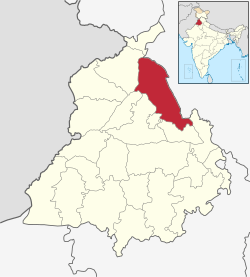 Location in Punjab, India | |
| Coordinates: 31°35′N 75°59′E | |
| Country | |
| State | Punjab |
| Region | Doaba |
| Headquarters | Hoshiarpur |
| Government | |
| • Deputy commissioner | Apneet Riyat [1] |
| Area | |
| • Total | 3,365 km2 (1,299 sq mi) |
| Population (2011)[‡] | |
| • Total | 1,586,625 |
| • Density | 470/km2 (1,200/sq mi) |
| • Sex Ration | 961 |
| Languages | |
| • Official | Punjabi |
| Time zone | UTC+5:30 (IST) |
| Literacy | 85.40% |
| Website | hoshiarpur |
Hoshiarpur along with the districts of Nawanshehar, Kapurthala and parts of Jalandhar represents one of the cultural region of Punjab called Doaba or the Bist Doab - the tract of land between two rivers namely Beas and Sutlej. The area along with the Shivalik foothills on the right side of Chandigarh-Pathankot road in Hoshiarpur is submountainous and this part of the district is also known as Kandi area. The two rivers, Sutlej and Beas along with two other seasonal streams provide drainage to the region. Besides these, the Kandi region is full of seasonal streams.
It falls into two nearly equal portions of hill and plain country. Its eastern face consists of the westward slope of the Solar Singhi Hills; parallel with that ridge, a line of lower heights belonging to the Siwalik Range traverses the district from south to north, while between the two chains stretches a valley of uneven width, known as the Jaswan Dun. Its upper portion is crossed by the Sohan torrent, while the Sutlej sweeps into its lower end through a break in the hills, and flows in a southerly direction until it turns the flank of the central range, and debouches westwards upon the plains. This western plain consists of alluvial formation, with a general westerly slope owing to the deposit of silt from the mountain torrents in the sub-montane tract. The Beas has a fringe of lowland, open to moderate but not excessive inundations, and considered very fertile. A considerable area is covered by government woodlands, under the care of the forest department. Rice is largely grown, in the marshy flats along the banks of the Beas. Several religious fairs are held, at Anandpur Sahib, Dasuya, Mukerian and Chintpurni, all of which attract an enormous concourse of people. The district, owing to its proximity to the hills, possesses a comparatively cool and humid climate. Cotton fabrics are manufactured, and sugar, rice, other grains and indigo are among the exports.[3]
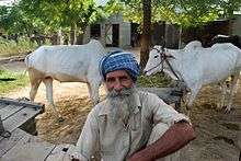
Hoshiarpur is also known as a City of Saints. There are many Deras in this district. The District Govt. College was once a campus for Punjab University. it was predominantly inhabited by Gujjar and Dogars of Kashmir Region during the reign of Sikh Empire
History
| Historical population | ||
|---|---|---|
| Year | Pop. | ±% p.a. |
| 1901 | 650,662 | — |
| 1911 | 603,685 | −0.75% |
| 1921 | 609,650 | +0.10% |
| 1931 | 678,526 | +1.08% |
| 1941 | 769,884 | +1.27% |
| 1951 | 712,440 | −0.77% |
| 1961 | 782,483 | +0.94% |
| 1971 | 948,505 | +1.94% |
| 1981 | 1,116,326 | +1.64% |
| 1991 | 1,299,261 | +1.53% |
| 2001 | 1,481,292 | +1.32% |
| 2011 | 1,586,625 | +0.69% |
| source:[4] | ||
The area of present Hoshiarpur District was also part of Indus Valley Civilization. Recent excavations at various sites in the district have revealed that the entire area near the Shivalik foothills was selected for habitation not only by the early Paleolithic man but also by those in the protohistoric and historic periods. The legends associate several places in the district with Pandavas. Dasuya is mentioned in epic of Mahabharata as the seat of Raja Virata in whose services the Pandavas remained for thirteen years during their exile. Bham, about 11 km west of Mahilpur, is said to be the place where the Pandavas passed their exile. Lasara, about 19 km north of Jaijon, also contains a stone temple stated to date back to the time of Pandavas. According to the Chinese pilgrim, Hieun Tsang, the area of Hoshiarpur was dominated by a tribe of Chandrabansi Rajputs, who maintained an independent existence for centuries before the Muhammadan conquest.
The country around Hoshiarpur formed part of the old kingdom of Katoch in Jalandhar. The state was eventually broken up, and the present district was divided between the, rajas of Datarpur and Jaswan. They retained undisturbed possession of their territories until 1759, when the rising Sikh chieftains commenced a series of encroachments upon the hill tracts. In 1815 Maharaja Ranjit Singh, forced the ruler of Jaswan to resign his territories in exchange for an estate on feudal tenure; three years later the raja of Datarpur met with similar treatment. By the close of the year 1818 the whole country from the Sutlej to the Beas had come under the government of Lahore, and after the First Anglo-Sikh War in 1846 passed to the British government. The deposed rajas of Datarpur and Jaswan received cash pensions from the new rulers, but expressed bitter disappointment at not being restored to their former sovereign position. Accordingly, the outbreak of the Second Anglo-Sikh War, in 1848 found the disaffected chieftains ready for rebellion. They organized a revolt, but the two rajas and the other ringleaders were captured, and their estates confiscated.[3] Hoshiarpur is an ancient centre of Hindu epics and culture itself. In Bajwara (4 km east on Una Road from the present city) ruins of an ancient culture can still be found. Mythologically, Teh Dasuya of this district is estimated to be King Virat's kingdom where Pandavas spent their one-year exile.
Bhrigu Samhita
Hoshiarpur is also highly popular for old astrological facts where it is said to be that old documents where past, present and future birth of every person is written in detail, are safely kept at this place. Many people visit Hoshiarpur to find out about their past, present and future in every birth they have or had taken in the past.
Significant cities
Among the numerous ancient cultural centers in Hoshiarpur was town Jaijon. Said to be Founded by Jaijjat rishi around 11th century at the Shivalik foothills, Jaijon was a flourishing trade centre. It was also known as a centre for oriental studies. Noted scholars and exponents of Sanskrit, Astrology, Ayurveda and music visited this place for meeting. Music composers Pandit Husan Lal and Bhagat Ram and noted Pakistani poet Tufail Hoshiarpuri belonged to the same place.
The late Ayurveda scholar Pandit Govind Ram Vatsyayan and the late Sanskrit laureate Acharya Vishwanath belonged to Jaijon. Over the years when Chandigarh came into existence Jaijon lost its glory and now it is a sleepy town on the border of Punjab and Himachal in the foothills of Shivaliks.
Mahilpur is an ancient village on the feet of Shivalik which was visited by Chinese Hyunshang who wrote this village as Sri Mahipalpur in his notes. Now Mahilpur has become a town.
Sadarpur is located near Garhshankar in the Shivalik Valley. It is a small town.
Jaijon still has a small old railway station from the British Era.
Area
At present, Hoshiarpur has an area of 3198.2 km².
- Total area (km²): 3,365
- Total No. of villages: 1,449
Demographics
Population
According to the 2011 census Hoshiarpur district has a population of 1,586,625,[6] roughly equal to the nation of Gabon[7] or the US state of Idaho.[8] This gives it a ranking of 31st in India (out of a total of 640).[6] The district has a population density of 683 inhabitants per square kilometre (1,770/sq mi).[6] Its population growth rate over the decade 2001-2011 was 17.95%.[6] Hoshiarpur has a sex ratio of 961 females for every 1000 males,[6] and a literacy rate of 85.40%.[6]
Scheduled Castes population in the district is 34 percent of the total population. The proportion of Scheduled Castes population in Hoshiarpur district is higher than the state’s Schedule Castes population (32 percent) and is ranked at the 5th position among all the districts. It may be mentioned that proportion of the Scheduled Castes population varies among blocks of Hoshiarpur district. In four blocks the population of Scheduled Castes is more than 40 percent. Two blocks namely, Hoshiarpur-I and Hoshiarpur-II have 48 percent Scheduled Castes population. In Mahilpur block the proportion of Scheduled Castes population is 44 percent and in Bhunga block it is 41 percent while in the remaining blocks the proportion of Scheduled Castes population is less than 40 percent. The Scheduled Caste population in this district is 34.3%[9][10]
Economy
In 2006 the Ministry of Panchayati Raj named Hoshiarpur one of the country's 250 most backward districts (out of a total of 640).[11] It is the only district in Punjab currently receiving funds from the Backward regions Grant Fund Programme (BRGF).[11]
Government and politics
District administration
- The Deputy Commissioner, an officer belonging to the Indian Administrative Service, is in-charge of the General Administration in the district. He is assisted by a number of officers belonging to Punjab Civil Service and other Punjab state services.
- The Senior Superintendent of Police, an officer belonging to the Indian Police Service, is responsible for maintaining law & order in the district. He is assisted by the officers of the Punjab Police Service and other Punjab police officials.
- The Divisional Forest Officer, an officer belonging to the Indian Forest Service, is responsible for the management of the forests, environment and wildlife in the district. He is assisted by the officers of the Punjab Forest Service and other Punjab forest officials and Punjab wildlife officials.
- Sectoral development is looked after by the district head/officer of each development department such as PWD, Health, Education, Agriculture, Animal husbandry, etc. These officers are from various Punjab state services.
Sub-Divisions
The District of Hoshiarpur comprises four sub-divisions, ten development blocks, eight municipal councils and one notified area committee, as listed below:
Administrative Divisions
- Hoshiarpur
- Dasuya
- Mukerian
- Garhshankar
Development Blocks
- Hoshiarpur-I
- Hoshiarpur-II
- Bhnga
- Tanda
- Dasuya
- Mukerian
- Talwara
- Hajipur
- Garhshankar
Municipal Corporation
Municipal Councils
- Garhdiwala
- Hariana
- Tanda
- Mahipur
- Garhshankar
- Dasuya'
- Mukerian
- Sham Chaurasi
- Talwara
Notified Area Committee
- Mahilpur
- Hoshiarpur
- Shamchurasi Kadiana
Notable people from Hoshiarpur District
Politics
- Kewal Krishan (10 October 1923 – 30 June 2008) Speaker of the Punjab Legislative Assembly (Vidhan Sabha), Minister of Finance in the Punjab Government 1980–83
- Mangu Ram Mugowalia, prominent Ghadar Party leader and Freedom Fighter[12]
- Harnam Singh Saini, an Indian revolutionary
- Giani Zail Singh was elected from Hoshiarpur in 1980. After that he became Union Home Minister and later the President of India in 1982.[13][14]
- Kanshi Ram founder of Bahujan Samaj Party won election from hoshiarpur in 1996 Indian general election
- Avinash Rai Khanna a Bharatiya Janata Party leader
- Santosh Chowdhary ex-MP Congress.
- Mayawati incontested M.P. election from Hoshiarpur 1989 Indian general election
- Ambika Soni M.P. belongs to bajwara in Hoshiarpur.[15]
- Jagjit Singh Chauhan founder of Khalsa Raj Party
- Rana Muhammad Hanif Khan Federal Minister of Finance, Pakistan (22 October 1974 – 28 March 1977) was born in Garhshankar, District Hoshiarpur[16]
- Vijay Sampla, (Minister of State for Social Justice and Empowerment) MP from Hoshiarpur is actually from Jalandhar city. (born at Sofi Village, Jalandhar district).
- Harjit Singh Sajjan, Minister of National Defence for the Government of Canada
Ch Rehmat Ali born in this city.
Arts and culture
.jpg)

- Bhai Sahib Singh one of the Panj Pyare
- Gauri Khan (born Gauri Chhibber) belongs to Hoshiarpur and raised up in Delhi.[17]
- Simran Kaur Mundi a Punjabi film actress is from village Mundian Jattan
- Yo Yo Honey Singh Punjabi Rapper from Delhi was born in Hoshiarpur.
- Monica Bedi a Punjabi actress is from village Chabbewal
- Piara Singh Gill, nuclear physicist
- Kulwinder Dhillon singer from Mahilpur
- Amar Singh Shaunki Dhadi singer
- Hard Kaur Indian rapper
- Soni Pabla, belongs to Bilaspur village, Hoshiarpur District
- D. P. Singh a science populariser and environmental activist of Punjab.
- Satinder Sartaaj Punjabi singer born in Bajrawar village, Hoshiarpur District
- Dr.Ganda Singh a Punjabi historian
- Intikhab Alam cricket player.
- Harbanse Singh Doman belongs to Hoshiarpur
- Ustad Amanat Ali Khan Pakistani classic and ghazal singer was born in Hoshiarpur
- Habib Jalib Pakistani revolutionary poet and left wing politician born in a village near Hoshiarpur.
- Upasana Singh actress in Bollywood and comedian in TV was born in Tanda.
- Nachhatar Gill Punjabi singer born in Vill. Akalgarh, near Garhshankar, Dist. Hoshiarpur.
- Mickey Singh,US based Punjabi Urban singer belongs to Hoshiarpur
- Jaz Dhami,UK based Punjabi singer belongs to Hoshiarpur
- Manmohan Waris,Punjabi folk singer belongs to Halluwal(near Mahilpur) District Hoshiarpur
Army
- Tufail Mohammad of Punjab Regiment (Pakistan), Recipient of Nishan-e-Haider
- Fazal Din of 7th Battalion 10th Baluch Regiment, British Indian Army, recipient of Victoria Cross.
References
- "District Administration". Retrieved 16 February 2015.
- "Census".
-

- Decadal Variation In Population Since 1901
- "Hoshiarpur District Population Census 2011-2019, Punjab literacy sex ratio and density". www.census2011.co.in.
- "District Census 2011". Census2011.co.in. 2011. Retrieved 30 September 2011.
- US Directorate of Intelligence. "Country Comparison:Population". Retrieved 1 October 2011.
Gabon 1,576,665
- "2010 Resident Population Data". U. S. Census Bureau. Archived from the original on 19 October 2013. Retrieved 30 September 2011.
Idaho 1,567,582
- "State-wise, District-wise List of Blocks with >40% but less than 50% SC population". Archived from the original on 23 July 2013. Retrieved 12 July 2012.
- "Jat Sikhs: A Question of Identity". Retrieved 12 July 2012.
- Ministry of Panchayati Raj (8 September 2009). "A Note on the Backward Regions Grant Fund Programme" (PDF). National Institute of Rural Development. Archived from the original (PDF) on 5 April 2012. Retrieved 27 September 2011.
- "THE GREAT REVOLUTIONARY BABU MANGU RAM MUGOWALIA".
- "Archived copy". Archived from the original on 28 November 2011. Retrieved 26 September 2011.CS1 maint: archived copy as title (link)
- "Archived copy". Archived from the original on 8 July 2012. Retrieved 28 December 2014.CS1 maint: archived copy as title (link)
- http://pbplanning.gov.in/pdf/MPLAD%20MPR%2031-5-2010.pdf
- Rana Mohammad Hanif Khan
- "SRK buys two miniplexes in his wife Gauri's hometown". 22 May 2014.
External links
Places adjacent to Hoshiarpur district | ||||||||||
|---|---|---|---|---|---|---|---|---|---|---|
| ||||||||||
