Sangrur district
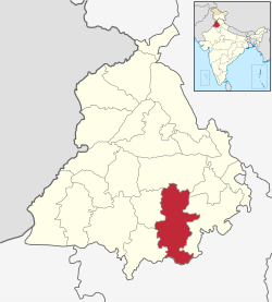
Sangrur district is in the state of Punjab in northern India. It is one of the four districts in Patiala Division in Indian Punjab.[1] Neighbouring districts are Ludhiana (North), Barnala (West), Patiala (East) and Fatehabad (Haryana).Three of its neighbouring districts lie in Punjab, while the fourth lies in Haryana.
Sangrur district | |
|---|---|
District | |
 | |
| Coordinates: 30.23°N 75.83°E | |
| Country | |
| State | Punjab |
| Headquarters | Sangrur |
| Area | |
| • Total | 3,685 km2 (1,423 sq mi) |
| Elevation | 232 m (761 ft) |
| Population (2011) | |
| • Total | 1,655,169 |
| • Density | 450/km2 (1,200/sq mi) |
| Languages | |
| • Official | Punjabi |
| Time zone | UTC+5:30 (IST) |
| PIN | 148001 |
| Telephone code | 01672 |
| Website | sangrur |
Sangrur consists of the cities of Dhuri, Lehragaga, Malerkotla, Sangrur, and Sunam. Other cities are Ahmedgarh, Amargarh, Bhawanigarh, Dirba, Khanauri, Longowal, Cheema, Sherpur and Moonak. There are 9 sub-divisions, being Sangrur, Malerkotla, Dhuri, Sunam, Lehragaga, Moonak, Ahmedgarh, Bhawanigarh and Dirba. Till 2006 Barnala was also a part of Sangrur district, but now it is a separate district.
Origin and History
The administrative district of Sangrur was created in 1948. Earlier the area fell in the Nabha Princely State. While reportedly established around 400 years ago by a Jat called Sanghu, settlements in Sangrur trace back to the pre-Harappan period. Recent excavations in Rohira in Sangrur have revealed a 10-metre high mound with settlements dating back to 2300 BC.[2] Excavations from Mard Khera village have led to the discovery of pottery from the Harappan period.[3] Remnants of pottery from the Kushan period have also been discovered.
Demographics
According to the 2011 census Sangrur district had a population of 1,655,169 of which male and female were 878,029 and 777,140 respectively roughly equal to the nation of Guinea-Bissau[4] or the US state of Idaho.[5] This gives it a ranking of 300st in India (out of a total of 640).
The district has a population density of 449 inhabitants per square kilometre (1,160/sq mi). Its population growth rate over the decade 2001-2011 was 12.3%. Sangrur has a sex ratio of 885 females for every 1000 males, and a literacy rate of 67.99%.
| Historical population | ||
|---|---|---|
| Year | Pop. | ±% p.a. |
| 1951 | 565,152 | — |
| 1961 | 696,418 | +2.11% |
| 1971 | 836,497 | +1.85% |
| 1981 | 1,026,166 | +2.06% |
| 1991 | 1,244,677 | +1.95% |
| 2001 | 1,473,242 | +1.70% |
| 2011 | 1,655,169 | +1.17% |
| source:[6] | ||
Administrative sub-divisions
Sangrur district is further sub-divided into 7 sub-divisions/tehsils - Dhuri, Lehragaga, Malerkotla, Moonak, Sangrur and Sunam, Dirba.
Notable people
- Gurchet Chitarkar, actor
- Binnu Dhillon, actor and comedian
- Parminder Singh Dhindsa, Politician
- Sukhdev Singh Dhindsa, Politician
- Naresh Goyal, founder of Jet Airways
- Saeed Jaffrey, actor
- Irshad Kamil, lyricist and poet
- Bhagwant Mann, actor, comedian and politician
- Rana Ranbir, actor, comedian, and writer
- Udham Singh, Indian independence activist, who assassinated Michael O'Dwyer in March 1940
See also
References
- "Sangrur, Punjab". Government of Punjab. Retrieved 5 June 2020.
- "Sangrur, History". Government of Punjab. Retrieved 5 June 2020.
- Sharma, Amaninder (5 September 2014). "Park may wipe out 'Harappan' site in Sangrur Village". The Times of India. Retrieved 5 June 2020.
- US Directorate of Intelligence. "Country Comparison:Population". Retrieved 1 October 2011.
Guinea-Bissau 1,596,677 July 2011 est.
- "2010 Resident Population Data". U. S. Census Bureau. Retrieved 30 September 2011.
Idaho 1,567,582
- Decadal Variation In Population Since 1901
- "9 OPDs to begin at PGI's satellite centre at Sangrur soon". Hindustan Times. 22 December 2015. Retrieved 8 September 2019.
External links
| Wikimedia Commons has media related to Sangrur district. |
Places adjacent to Sangrur district | ||||||||||
|---|---|---|---|---|---|---|---|---|---|---|
| ||||||||||
