Bathinda
Bathinda is a city and Municipal Corporation in South-western part of Punjab, India. It is one of the oldest cities in Punjab, India and the current administrative headquarters of Bathinda District. It is in northwestern India in the Malwa Region, 227 km west of the capital city of Chandigarh and is the fifth largest city of Punjab. Bathinda's nicknamed the 'City of Lakes', courtesy of the artificial lakes in the city.
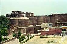
The first empress Delhi Sultanate Razia Sultan was imprisoned in the Chauhan Durg fort in Bathinda.[1] The gurudwara of Haji Rattan is a popular tourist centre of Bathinda having connections with popular legends.[2]
Bathinda is a home of Central University of Punjab and upcoming AIIMS. Bathinda is home to two modern thermal power plants, Guru Nanak Dev Thermal Plant and Guru Hargobind Thermal Plant at Lehra Mohabbat.[3] The city has a fertilizer plant,[4] two cement plants (Ambuja Cements and UltraTech Cement Limited), a large army cantonment, an air force station, a zoo,[3] and a historic Qila Mubarak fort.[5]
History
Bhatinda was changed to Bathinda to conform to the phonetical expression as locally pronounced.[6] According to Henry George Raverty, Bathinda was known as Tabarhindh (Labb-ut-Twarikh). The earliest mention of Tabarhindh occurs in the Jami-Ul-Hakayat written about 607 Hijri or 1211 AD.
In 1004, Mahmud of Ghazni besieged the local fort, which was located on the route from the northwest into the rich Ganges valley.
In 1189, Muhammad Ghori attacked and occupied the fort of Bathinda. Prithvi Raj Chauhan, the ruler of this region, managed to recover possession of the fort thirteen months later in 1191 after the First Battle of Tarain.
In 1634, a battle named Battle of Lahira (at Lahira in Bathinda) was fought between Guru Hargobind and Mughals.
In circa 1754, the town was conquered by Maharaja Ala Singh, the Maharaja of Patiala and since then it followed the history of erstwhile princely state of Patiala. With the dawn of independence and merger of Patiala and East Punjab States into a division called PEPSU, Bathinda become a full-fledged district with headquarters at Bathinda city.[6]
Demographics
Population
As per provisional reports of Census India, population of Bathinda city in 2011 is 285,813; male and female are 151,782 and 134,031 respectively. The sex ratio of Bathinda city is 868 females per 1000 males. The number of literate people in Bathinda city are 211,318 of which 118,888 are males while 92,430 are females, average literacy rate is 82.84 percent of which male and female literacy is 87.86 and 77.16 percent respectively. Total children (ages 0 to 6) in Bathinda city are 30,713: 16,472 boys and 14,241 girls. Child sex ratio of girls is 865 per 1000 boys.[7]
Religion
Hinduism is the majority religion in Bathinda city with 62.61% people following the faith. Sikhism is the second most popular religion in the city which is followed by 35.04% of the people. Minorities are Muslims, Christians, Buddhists and Jains. Sikhs count for 70.89% of the population in Bathinda District on a whole in spite of not being a majority in the city.[8]
Geography and climate
Bathinda is in the northwestern region of India and is a part of the Indo-Gangetic alluvial plains. The exact cartographic co-ordinates of Bathinda are 30.20°N 74.95°E.[10] It has an average elevation of 201 metres (660 ft).
| Bathinda | ||||||||||||||||||||||||||||||||||||||||||||||||||||||||||||
|---|---|---|---|---|---|---|---|---|---|---|---|---|---|---|---|---|---|---|---|---|---|---|---|---|---|---|---|---|---|---|---|---|---|---|---|---|---|---|---|---|---|---|---|---|---|---|---|---|---|---|---|---|---|---|---|---|---|---|---|---|
| Climate chart (explanation) | ||||||||||||||||||||||||||||||||||||||||||||||||||||||||||||
| ||||||||||||||||||||||||||||||||||||||||||||||||||||||||||||
| ||||||||||||||||||||||||||||||||||||||||||||||||||||||||||||
Bathinda's climate corresponds to semi-arid with high variation between summer and winter temperatures. Average annual rainfall is relatively low, in a range of 20 mm to 40 mm.[11]
In recent times, Summer temperatures of 49 °C (120 °F)[12] and winter temperatures of 1 °C (about 33 °F)[13] were not unknown in Bathinda, lowest being -1.4 °C (29.48 °F) in the winter of 2013[14]
Transportation
Bhatinda Railway Station has connectivity to most of the major cities in India. Four national highways: NH 7 (Fazilka - Badrinath National Highway), NH 54 (Kenchiyan, Hanumangarh - Pathankot National Highway), NH 148B (Bathinda to Kotputli) and NH 754 (Bathinda to Jalalabad, Fazilka) pass through/near the city.[15]
Education
School education and exam coaching institutions
College education
Colleges within Bathinda include:
Central University of Punjab
The Central University of Punjab Bathinda (Punjab) has been established through the Central Universities Act 2009 which received the assent of the President of India on 20 March 2009. Its territorial jurisdiction extends to the whole State of Punjab.
It started its functioning from Camp Office in April 2009, which happens to be the residence of the Vice Chancellor, and from November 2009 it shifted to its City Campus spread over an area of 35 acres. Construction of the main campus has started on 540 acres of land in Ghudda Village (21.5 km from Bathinda ISBT) on Badal Road. Engineers India Limited, a Navratna Public Sector Undertaking, is providing PMC services for the project.[18]
Maharaja Ranjit Singh Punjab Technical University
Maharaja Ranjit Singh Punjab Technical University (MRSPTU), formerly Maharaja Ranjit Singh State Technical University, is a State technical university of Punjab located in Bathinda, Punjab, India. It was established in 2015 and has jurisdiction over 11 districts namely Bathinda, Ferozepur, Moga, Faridkot, Sri Muktsar Sahib, Barnala, Mansa, Sangrur, Patiala, Fatehgarh Sahib and Fazilka. University will function from upgraded Giani Zail Singh Punjab Technical University Campus.[19]
Adesh Institute of Medical Science and Research
Adesh Institute of Medical Sciences & Research (AIMSR) is a private not for profit Medical College associated with a 750-bed Tertiary Care Teaching hospital. It has 150 M.B.B.S. annual seat intake. The college is located on the Barnala Bathinda Highway. The college was established in 2006 under Adesh Institutions. AIMSR is approved by Medical Council of India and permitted by Ministry of Health & Family Welfare. It was affiliated to Baba Farid University of Health Sciences, Faridkot from 2006 to 2011 MBBS Admissions Batch and is affiliated to Adesh University, Bathinda starting 2012.
Notable people
- Harbhajan Mann, actor and singer
- Rajinder Gupta, businessman, founder of TridentGroup
- Mehar Mittal, actor and producer
- Mayank Markande, cricketer
- Manny Aulakh, Canadian international cricketer
- Avneet Sidhu, Commonwealth games gold-winning shooter
- Parduman Singh Brar, Shotputter, Asiad gold medallist
- Balkar Sidhu, singer
- Amrit Maan, actor, singer and lyricist
- Balwant Gargi, writer and dramatist
- Riaz ur Rehman Saghar, Pakistani poet and lyricist
- Gurdial Singh, novelist
- Kuldeep Manak, singer
- Janmeja Singh Sekhon, politician
- Sunny and Inder Bawra, composer duo
- Kul Sidhu, theatre artist and actress
- Mehreen Pirzada, actress
Environmental Issues
There has been increasing incidence of various types of cancer in and around Bathinda. It is attributed to the presence of polluting industries and the indiscriminate use of modern pesticides and other toxic materials in farming. A 2007 epidemiological study found that the surface waters of Bathinda are contaminated with arsenic, cadmium, chromium, selenium and mercury primarily due to the discharge of untreated waste water from surrounding industries. Unscientific farming practices, that emerged after the introduction of Green Revolution, are also alleged to be a reason for growing incidence of not just cancer but also, high rates of spontaneous abortions, reproductive ailments, genetic deformities, anaemia, diarrhoea, vomiting, fluorosis and a host of skin ailments including rashes and boils. Many young couples are also reported to be migrating out to save their children from adverse effects. Hence the government has completely banned the use of ground water in the city for drinking purposes.[20]
Suburbs of Bathinda
- Bhucho Mandi 15 km
- Goniana 14 km
- Maur Mandi 37 km
- Rampura Phul 30 km
- Talwandi Sabo 29 km
- Raman 42 km
- Sangat, India 21 km
See also
References
- "Raziya Sultan". Archived from the original on 31 March 2012. Retrieved 7 May 2012.
- https://www.nativeplanet.com/bathinda/attractions/mazaar-of-peer-haji-rattan/#overview
- "Places to Visit". Archived from the original on 26 November 2009. Retrieved 25 November 2009.
- "Industry". Archived from the original on 7 June 2005.
- "Archived copy". Archived from the original on 19 July 2011. Retrieved 27 July 2008.CS1 maint: archived copy as title (link)
- "District at A glance". Archived from the original on 10 January 2011. Retrieved 3 January 2011.
- "Census 2011".
- "Bathinda District Population Census 2011, Punjab literacy sex ratio and density".
- "Bathinda City Population Census 2011 - Punjab".
- "Maps, Weather, and Airports for Bhatinda, India".
- http://www.mapsofindia.com/ maps/india/annualrainfall.htm
- under the section 'historical monthly average for may', subsection 'temperature', http://www.myweather2.com/City-Town/India/Bhatinda/climate-profile.aspx?month=5
- under the section 'historical monthly average for Jan', subsection 'temperature', http://www.myweather2.com/City-Town/India/Bhatinda/climate-profile.aspx?month=1
- A news report, "Archived copy". Archived from the original on 31 May 2014. Retrieved 30 May 2014.CS1 maint: archived copy as title (link)
- "National Highways of India" (PDF). National Highway Authority of India. Wayback Machine. Archived from the original (PDF) on 27 January 2018. Retrieved 27 January 2018.
- "Welcome to DAV College, Bathinda".
- "State Government Affiliated Institutes of Hotel Management | NCHMCT". National Council For Hotel Management and Catering Technology. Retrieved 22 January 2020.
- http://www.cup.ac.in/publications/newsletter_vol.1%3B%20no.3%3B%20august-october2013.pdf
- "About MRSPTU". Retrieved 27 June 2018.
- "Cancer Bathinda's dubious distinction". 6 September 2011 – via The Hindu.
External links
| Wikimedia Commons has media related to Bathinda. |
