Mohali district
Mohali district, officially known as Sahibzada Ajit Singh Nagar district or SAS Nagar district[1], is one of the twenty two districts of Punjab a state in north-west India. It was formed in April 2006[2][3] and is 18th district of Punjab, created next to Pathankot district. This district was carved out of areas falling in Ropar and Patiala District. It is situated next to the union territory of Chandigarh and Panchkula district of Haryana.
Mohali district Sahibzada Ajit Singh Nagar district | |
|---|---|
District | |
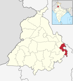 Location in Punjab, India | |
| Coordinates: 30.69°N 76.72°E | |
| Country | |
| State | Punjab |
| Established | 14 April 2006 |
| Headquarters | Mohali |
| Area | |
| • Total | 1,098 km2 (423.9402 sq mi) |
| Population (2011) | |
| • Total | 994,628 |
| • Density | 910/km2 (2,300/sq mi) |
| Languages | |
| • Official | Punjabi |
| Time zone | UTC+5:30 (IST) |
| ISO 3166 code | IN-PB-SA |
| Website | www |
The district is officially named after the eldest son of Guru Gobind Singh, Sahibzada Ajit Singh.
History
| Historical population | ||
|---|---|---|
| Year | Pop. | ±% p.a. |
| 1901 | 106,038 | — |
| 1911 | 91,837 | −1.43% |
| 1921 | 91,150 | −0.08% |
| 1931 | 100,135 | +0.94% |
| 1941 | 114,071 | +1.31% |
| 1951 | 188,619 | +5.16% |
| 1961 | 236,753 | +2.30% |
| 1971 | 295,199 | +2.23% |
| 1981 | 407,161 | +3.27% |
| 1991 | 548,276 | +3.02% |
| 2001 | 746,987 | +3.14% |
| 2011 | 994,628 | +2.90% |
| source:[4] | ||
1987 Lalru bus massacre on 5 October 1983 took place at Lalru in which 38 Hindu were killed by pro-Khalistan Sikh anti-Government militants at Lalru on haryana-Punjab border near Chandigarh presently in Mohali District, when a bus going from Dhilwan in Kapurthala district to Jalandhar was attacked by Sikh militants to drive out the million Hindus living in the state of Punjab and force the Sikhs living outside of the Punjab state to move in to enable the Sikh separatists to claim the Punjab state as a sovereign country of Khalistan.[5][6][6]
Rural development blocks
Kharar block
This block consists of 154 villages and 2 towns namely Ajitgarh and Kharar and there 4 un-inhabited villages. As per the 2001 census, the total population of the block is 369,798. The rural population of the block is 196,044 out of which there are 106,688 males and 89,356 females. The total Scheduled Caste population in the rural area is 55,544. The block is having total area of 411.32 km2. Out of which the rural area covers 383.26 km2.
Under the service area approach, all the villages have been allocated among 17 branches of commercial banks and 4 branches of RPBs. There are a total of 86 branches are functioning in the block which comprises 57 commercial banks, 13 private banks. 11 Coop. Banks, 4 Punjab Gramin Banks, and 1 Agricultural Development bank. S.A.S. Nagar has emerged as an Industrial Focal Point and designated as District Headquarters. It has become a satellite town of Chandigarh and has registered a fast rate of growth.
Majri block
Majri Block comprises 116 villages out of which 1 village is un-inhabited. This block forms part of the Kharar subdivision. The total population of the block is 111,598 as per the 2001 census. The population in the rural area is 88551, out of which 47,892 are males and 40,659 are female. The S.C. population in the rural area is 25,531. Kurali is the only town in the block and has a population of 23,047. This block is spread over an area 274.84 km2. The block comes under the dark category. All the villages numbering 116 have been allocated among 8 branches of commercial banks and one branch of P.G.B. There are 16 branches operating in this block which comprises 9 branches of commercial banks. 1 Pvt. Sector Bank, One branch of PGB and SAS Nagar central co-operative bank is having 5 branches. Due to certain incentives being initiated by the Govt. many large and small-scale industrial units have been established around Kurali.
Dera Bassi block
This block consists of 144 villages and 2 towns namely Zirakpur and Dera Bassi and there are 6 un-inhabited villages. As per the 2001 census, the total population of the block is 216,921. The rural population of the block is 170192 out of which there are 93,116 males and 77,076 females. The total S.C. population lin the rural area is 48,683. This block is having total area of 406.48 km2. Out of which the rural area covers 371.17 km2. Dera Bassi block has a good number of small scale units. Chemical paints, Steel tubes, plywood, handlooms, and knitting of Daris are some of the industries which have offered good employment to a number of persons. The soil of the block is sandy to sandy loam. There are a total of 25 branches are functioning in the block which comprises 19 commercial banks, 1 private bank, 3 coops. banks, 1 Malwa Gramin Bank & 1 agricultural development bank. Zirakpur and had a very fast development and has become a part of Greater Chandigarh.
Areas in SAS Nagar district
Areas within the district include:
- Zirakpur
- New Chandigarh
- Kharar
- Bakarpur
- Bhankharpur
- Banur
- Chappar Chiri
- Daon
- Mohali or Sahibzada Ajit Singh Nagar
- Mubarik Pur
- Sohana
- Kurali
- Kumbhra
- Dera Bassi
- Mattaur
- Tewar (Tiaur)
- Nayagaon
- Lalru
- Jhande Majra
- Dappar
- Machhli Kalan
Architecture
Fateh Burj
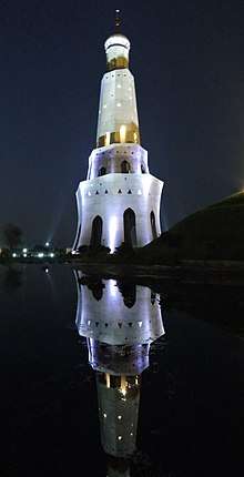
The Fateh Burj (English: The Victory Tower; Punjabi: ਫਤਿਹ ਬੁਰਜ) is the tallest victory tower (Minar) in the country.[7] The 328 ft tower is dedicated to the establishment of Sikh rule in India in 1711.[8] It is also known as Baba Banda Singh Bahadur War Memorial. It was here that Banda Singh Bahadur, one of the most respected Sikh warriors, won a decisive battle against Wazir Khan, commander of the Mughal army.[3]
Demographics
According to the 2011 census, SAS Nagar district has a population of 994,628,[9] roughly equal to the nation of Fiji[10] or the US state of Montana.[11] This gives it a ranking of 450th in India (out of a total of 640).[9] The district has a population density of 830 inhabitants per square kilometre (2,100/sq mi) .[9] Its population growth rate over the decade 2001-2011 was 32.02%.[9] SAS Nagar has a sex ratio of 878 females for every 1,000 males,[9] and a literacy rate of 84.9%.[9]
References
- It’s Sahibzada Ajit Singh Nagar, not Ajitgarh: DC: Retrieved from The Tribune: Nov 28 2014
- SAS Nagar to become a district: Retrieved from The Tribune: 20060228
- "About NIC District Centre S.A.S. NAGAR MOHALI (MOHALI)". Archived from the original on 16 February 2012.
- Decadal Variation In Population Since 1901
- Tempest, Rone (26 July 1986). "Suspected Sikh Terrorists Kill 15 on India Bus". Los Angeles Times. Retrieved 17 October 2018.
- "Terrorists kill bus passengers in Punjab and Haryana mercilessly". India Today. 31 July 1987. Retrieved 26 October 2018.
- "Badal inaugurates tallest victory tower". MSN. 30 November 2011. Archived from the original on 3 January 2013. Retrieved 18 November 2012.
- Bajwa, Harpreet (1 December 2011). "Fateh Burj, India's tallest victory tower, thrown open". Indian Express. Retrieved 18 November 2012.
- "District Census 2011". Census2011.co.in. 2011. Retrieved 30 September 2011.
- US Directorate of Intelligence. "Country Comparison:Population". Retrieved 1 October 2011.
Fiji 883,125 July 2011 est.
- "2010 Resident Population Data". U. S. Census Bureau. Retrieved 30 September 2011.
Montana 989,415
- http://www.census2011.co.in/census/district/605-mohali.html
External links
| Wikimedia Commons has media related to Mohali district. |
Places adjacent to Mohali district | ||||||||||
|---|---|---|---|---|---|---|---|---|---|---|
| ||||||||||
