Harford County, Maryland
Harford County is a county in the U.S. state of Maryland. As of the 2010 census, the population was 244,826.[1] Its county seat is Bel Air.[2] Harford County is included in the Baltimore-Columbia-Towson, MD Metropolitan Statistical Area, which is also included in the Washington-Baltimore-Arlington, DC-MD-VA-WV-PA Combined Statistical Area.
Harford County | |
|---|---|
 Harford County Courthouse | |
 Flag  Seal | |
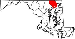 Location within the U.S. state of Maryland | |
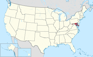 Maryland's location within the U.S. | |
| Coordinates: 39°32′N 76°18′W | |
| Country | |
| State | |
| Founded | December 17, 1773 |
| Named for | Henry Harford |
| Seat | Bel Air |
| Largest city | Aberdeen |
| Area | |
| • Total | 527 sq mi (1,360 km2) |
| • Land | 437 sq mi (1,130 km2) |
| • Water | 90 sq mi (200 km2) 17%% |
| Population (2010) | |
| • Total | 244,826 |
| • Estimate (2019) | 255,441 |
| • Density | 460/sq mi (180/km2) |
| Time zone | UTC−5 (Eastern) |
| • Summer (DST) | UTC−4 (EDT) |
| Congressional districts | 1st, 2nd |
| Website | www |
History
In 1608 the area was settled by Massawomecks and Susquehannocks.[3]:16–17 The first European to see the area was John Smith in 1608 when he traveled up the Chesapeake Bay from Jamestown.[3]:14–15 In 1652 the English and Susquehannocks signed a treaty at what is now Annapolis for the area now called Harford County.[3]:24
Harford County was formed on March 22, 1774 from the eastern part of Baltimore County with a population of 13,000 people.[3]:13,60 On March 22, 1775 Harford County hosted the signers of the Bush Declaration, a precursor document to the American Revolution.[3]:102 On January 22, 1782 Bel Air became the county seat.[3]:67
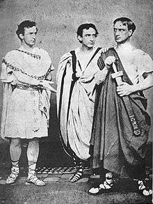
After supposedly marrying Mary Ann Holmes in 1821 Junius Brutus Booth Sr. moved to the county into a log cabin before building Tudor Hall in 1847.[4] Junius Brutus Booth Sr. "was followed as a marvel. Mention of his name stirred an enthusiasm no other could awaken."[5]:149 Junius Brutus Booth Jr. was born to the couple in Bel Air, Harford County, Maryland in 1821 before managing the Boston Theatre, Walnut Street Theatre, Winter Garden Theatre, and Booth's Theatre where his younger brother Edwin was the star attraction. Though a relatively undistinguished actor, Junius Jr. was highly regarded for his performances as King John and Cassius in Julius Caesar, which he performed with Edwin as Brutus and John Wilkes as Mark Antony in 1864.[6] He married Agnes Land Perry in 1867. He retired in 1881 to Masconomo House in Manchester-by-the-Sea, Massachusetts, where he died on September 17, 1883.[7] Edwin Booth was also born in Bel Air but in 1833 and later toured America and Europe performing plays by Shakespeare before founding Booth's Theatre in New York in 1869.[8][9] Edwin was a Unionist.[10]
Born in the same log cabin but in 1838 John Wilkes Booth made his stage debut at age 17 on August 14, 1855 in the supporting role of the Earl of Richmond in Richard III at Baltimore's Charles Street Theatre.[11] Some of the more known theaters that he acted for include John T. Ford's Holliday Street Theater in Baltimore, Arch Street Theatre in Philadelphia, and the Richmond Theatre.[12] Of all Shakespearean characters his favorite role was Brutus the slayer of a tyrant.[13] Some critics called him "the handsomest man in America," a "natural genius", and praised his "astonishing memory" while others gave mixed reviews of his acting.[14] Historian Benjamin Platt Thomas wrote that Booth "won celebrity with theater-goers by his romantic personal attraction."[15]
Author Gene Smith wrote that Booth's acting may not have been as precise as his brother Edwin's, but his strikingly handsome appearance enthralled women.[16] As the 1850s drew to a close, Booth was becoming wealthy as an actor, earning $20,000 a year (equivalent to about $569,000 today).[17] Despite the acting fame of the entire Booth family, John Wilkes Booth will always be most known for assassinating Abraham Lincoln.[18]
Havre de Grace, a city incorporated in 1785 within Harford County, was once under consideration to be the capital of the United States rather than Washington, D.C.[3]:250 It was favored for its strategic location at the top of the Chesapeake Bay; this location would facilitate trade while being secure in time of war.[19] Today, the waterways around Havre de Grace have become adversely affected by silt runoff, which is one of the primary environmental issues of Harford County.[20] While today the site is a Maryland National Guard military reservation, the land was used as the Havre de Grace Racetrack where racehorse Man o' War ran in 1919 and 1920.[21]
During the 1900s the Bata Shoe Company employed numerous Eastern European refugees at the Belcamp factory.[22]:4 In the 1940s the Susquehanna River tributary Broad Creek was dammed to form the 55 acres (0.22 km2) at what is now the Broad Creek Memorial Scout Reservation.[23] In June 1972 Hurricane Agnes overflowed the dam and flooded areas in many states.[24] On the County Health Rankings & Roadmaps by the Robert Wood Johnson Foundation with the University of Wisconsin Population Health Institute, "prior to the 2016 report ... Harford's yearly rankings[25] typically fell between ninth and 10th place, primarily because of the percentage of county residents who were obese or who smoked."[26] Scenes from Tuck Everlasting, From Within, and House of Cards were all filmed in Harford County.
In 2011 the Office of National Drug Control Policy deemed Harford County a designated High Intensity Drug Trafficking Area.[27]
The county was named for Henry Harford (ca. 1759–1834), the illegitimate son of Frederick Calvert, 6th Baron Baltimore. Henry Harford was born to Calvert's mistress, Hester Whelan, whose residence still stands as part of a private residence on Jarretsville Pike, in Phoenix, Maryland. Harford served as the last Proprietary Governor of Maryland but, because of his illegitimacy, did not inherit his father's title.[3]:53 There are 79 properties and districts listed on the National Register in the county, including one National Historic Landmark called Sion Hill.[28]
Environmental history
Harford County has environmental issues in three major areas: land use, water pollution/urban runoff, and soil contamination/groundwater contamination.
As the county sits at the headwaters of the Chesapeake Bay along the Susquehanna River, it plays a key role in controlling sediment and fertilizer runoff into the bay as well as fostering submerged aquatic vegetation (SAV) regrowth. The county has had to balance the needs of land owners to practice agriculture and/or pave land (creating impervious surfaces) with effects of runoff into the bay.
Harford County has been burdened by soil contamination and groundwater contamination since the creation of the Aberdeen Proving Ground. The military installation performs research for the U.S. Army and has released various chemical agents into soil and groundwater, including mustard gas and perchlorate. The bordering towns of Aberdeen, Edgewood and Joppatowne have been affected by this contamination.[29][30] Aberdeen Proving Ground contains three Superfund priority sites as of 2006. Groundwater contamination by MTBE, a mandatory gasoline additive, has also affected Fallston.[31][32]
Harford County also faces controversy from residents living near Scarboro Landfill and Harford Waste Disposal Center, the only municipal landfill. The landfill, approved to triple in size in 2007, is the subject of complaints by neighbors of operating violations, such as large areas of open trash and blown litter, leachate breaks which contaminate area residential wells and flow into Deer Creek, a tributary of the Susquehanna River, and increased health problems.
Geography

According to the U.S. Census Bureau, the county has a total area of 527 square miles (1,360 km2), of which 437 square miles (1,130 km2) is land and 90 square miles (230 km2) (17%) is water.[33]
Harford County straddles the border between the rolling hills of the Piedmont Plateau and the flatlands of the Atlantic Coastal Plain along the Chesapeake Bay and its tributaries. The county's development is a mix of rural and suburban, with denser development in the larger towns of Aberdeen and Bel Air and along Route 40 and other major arteries leading out of Baltimore. The highest elevations are in the north and northwest of the county, reaching 805 ft. near the Pennsylvania border in the county's northwestern corner. The lowest elevation is sea level along the Chesapeake Bay.
Adjacent counties
- York County, Pennsylvania (north)
- Lancaster County, Pennsylvania (northeast)
- Cecil County (east)
- Kent County (south)
- Baltimore County (west)
National protected area
Communities
Town
- Bel Air (county seat)
Unincorporated communities
Census-designated places
Governance
Harford County is, like the Pennsylvania Dutch Country to its north, a strongly Republican region. No Democratic presidential candidate has carried Harford County since Lyndon Johnson’s landslide of 1964. In the period before World War II Harford leaned strongly Democratic as it had sizeable Confederate sympathies,[35] but during and since the Second World War the county has turned away from its traditional allegiances.
| Year | Republican | Democratic | Third parties |
|---|---|---|---|
| 2016 | 58.3% 77,860 | 35.2% 47,077 | 6.5% 8,735 |
| 2012 | 57.9% 72,911 | 39.5% 49,729 | 2.6% 3,314 |
| 2008 | 58.2% 71,751 | 39.4% 48,552 | 2.4% 2,992 |
| 2004 | 63.5% 71,565 | 35.2% 39,685 | 1.3% 1,478 |
| 2000 | 57.8% 52,862 | 39.0% 35,665 | 3.2% 2,897 |
| 1996 | 50.8% 39,686 | 38.1% 29,779 | 11.2% 8,726 |
| 1992 | 45.1% 36,350 | 33.7% 27,164 | 21.3% 17,173 |
| 1988 | 65.7% 38,493 | 33.8% 19,803 | 0.5% 270 |
| 1984 | 68.4% 37,382 | 31.4% 17,133 | 0.2% 127 |
| 1980 | 52.4% 26,713 | 39.3% 20,042 | 8.2% 4,186 |
| 1976 | 55.0% 24,309 | 45.0% 19,890 | |
| 1972 | 73.2% 25,141 | 25.4% 8,737 | 1.4% 488 |
| 1968 | 51.5% 15,799 | 32.3% 9,914 | 16.2% 4,978 |
| 1964 | 42.4% 9,968 | 57.6% 13,550 | |
| 1960 | 56.5% 12,090 | 43.5% 9,293 | |
| 1956 | 65.8% 12,657 | 34.2% 6,588 | |
| 1952 | 61.0% 10,770 | 38.6% 6,809 | 0.5% 80 |
| 1948 | 52.5% 6,168 | 46.8% 5,494 | 0.8% 88 |
| 1944 | 58.3% 6,751 | 41.8% 4,839 | |
| 1940 | 53.9% 6,501 | 45.6% 5,500 | 0.5% 59 |
| 1936 | 46.2% 5,327 | 53.5% 6,165 | 0.3% 39 |
| 1932 | 39.0% 3,954 | 59.9% 6,073 | 1.1% 107 |
| 1928 | 64.5% 6,479 | 34.9% 3,506 | 0.6% 55 |
| 1924 | 45.7% 3,545 | 49.5% 3,841 | 4.8% 372 |
| 1920 | 49.9% 4,175 | 49.4% 4,134 | 0.8% 65 |
| 1916 | 40.2% 2,302 | 58.4% 3,345 | 1.5% 85 |
| 1912 | 30.4% 1,737 | 53.6% 3,064 | 16.0% 912 |
| 1908 | 45.9% 2,742 | 52.7% 3,148 | 1.4% 82 |
| 1904 | 43.9% 2,561 | 54.0% 3,151 | 2.1% 121 |
| 1900 | 45.4% 3,145 | 50.7% 3,509 | 3.9% 271 |
Harford County was granted a charter form of government in 1972. This means that the county is run by a County Executive and Council President, both elected at large, as well as Council Members, elected from districts. Currently, there are six districts in Harford County. Also elected at large is the Sheriff, who runs the Harford County Sheriff's Office.
Executive
The Harford County Executive is Barry Glassman (Republican). Primary law enforcement in the county is handled by the Harford County Sheriff's Office, which has precincts in Jarrettsville, Edgewood and Bel Air. The current Sheriff is Jeffrey Gahler (R). The Maryland State Police also have a barrack located in Bel Air which serves the citizens of Harford County. Municipal police needs are provided by the Bel Air Police Department, the Aberdeen Police Department and the Havre De Grace Police Department. The current State's Attorney is Joseph I. Cassilly. Directors are nominated by the Executive and approved by the Council. The Volunteer Fire & EMS Association department[37] is led by Russell Eyre.[38]
Council

Patrick Vincenti is the council president. Andre V. Johnson represents district A which includes Joppa and Edgewood. Joseph Woods represents district B which includes Abingdon and Fallston. Tony "G" Giangiordano represents district C which includes Bel Air and Forest Hill. Chad Shrodes represents district D which includes Jarrettsville, Street, and Darlington. Robert Wagner represents district E which includes Churchville and Aberdeen. Curtis Beulah represents district F which includes Belcamp and Havre de Grace.
Demographics
| Historical population | |||
|---|---|---|---|
| Census | Pop. | %± | |
| 1790 | 14,976 | — | |
| 1800 | 17,626 | 17.7% | |
| 1810 | 21,258 | 20.6% | |
| 1820 | 15,924 | −25.1% | |
| 1830 | 16,319 | 2.5% | |
| 1840 | 17,120 | 4.9% | |
| 1850 | 19,356 | 13.1% | |
| 1860 | 23,415 | 21.0% | |
| 1870 | 22,605 | −3.5% | |
| 1880 | 28,042 | 24.1% | |
| 1890 | 28,993 | 3.4% | |
| 1900 | 28,269 | −2.5% | |
| 1910 | 27,965 | −1.1% | |
| 1920 | 29,291 | 4.7% | |
| 1930 | 31,603 | 7.9% | |
| 1940 | 35,060 | 10.9% | |
| 1950 | 51,782 | 47.7% | |
| 1960 | 76,722 | 48.2% | |
| 1970 | 115,378 | 50.4% | |
| 1980 | 145,930 | 26.5% | |
| 1990 | 182,132 | 24.8% | |
| 2000 | 218,590 | 20.0% | |
| 2010 | 244,826 | 12.0% | |
| Est. 2019 | 255,441 | [39] | 4.3% |
| U.S. Decennial Census[40] 1790–1960[41] 1900–1990[42] 1990–2000[43] 2010–2018[1] | |||
2000 census
As of the census[44] of 2000, there were 218,590 people, 79,667 households, and 60,387 families residing in the county. The population density was 496 people per square mile (192/km²). There were 83,146 housing units at an average density of 189 per square mile (73/km²). The racial makeup of the county was 86.77% White, 9.27% African-American, 0.23% Native American, 1.52% Asian, 0.06% Pacific Islander, 0.69% from other races, and 1.47% from two or more races. 1.91% of the population were Hispanic or Latino of any race. 22.5% were of German, 13.1% Irish, 9.8% Italian, 9.2% English, 8.1% "American" and 6.0% Polish ancestry.
By 2006 the population of Harford County had risen 10.4% to 241,402.[45]
The 2005 report on race and ethnicity indicated the county's population was 82.8% non-Hispanic whites. The proportion of African-Americans in the county had risen to 11.5%. Hispanics were now 2.4% of the total population.[45]
In 2000 there were 79,667 households out of which 38.70% had children under the age of 18 living with them, 61.90% were married couples living together, 10.20% had a female householder with no husband present, and 24.20% were non-families. 19.70% of all households were made up of individuals and 6.80% had someone living alone who was 65 years of age or older. The average household size was 2.72 and the average family size was 3.14.
In the county, the age distribution of the population shows 27.90% under the age of 18, 6.80% from 18 to 24, 31.60% from 25 to 44, 23.70% from 45 to 64, and 10.10% who were 65 years of age or older. The median age was 36 years. For every 100 females there were 96.00 males. For every 100 females age 18 and over, there were 92.50 males.
The median income for a household in the county was $57,234, and the median income for a family was $63,868. Males had a median income of $43,612 versus $30,741 for females. The per capita income for the county was $24,232. About 3.60% of families and 4.90% of the population were below the poverty line, including 5.80% of those under age 18 and 6.70% of those age 65 or over.
2010 census
As of the 2010 United States Census, there were 244,826 people, 90,218 households, and 66,335 families residing in the county.[46] The population density was 560.1 inhabitants per square mile (216.3/km2). There were 95,554 housing units at an average density of 218.6 per square mile (84.4/km2).[47] The racial makeup of the county was 81.2% white, 12.7% black or African American, 2.4% Asian, 0.3% American Indian, 0.1% Pacific islander, 0.9% from other races, and 2.5% from two or more races. Those of Hispanic or Latino origin made up 3.5% of the population.[46] In terms of ancestry, 28.1% were German, 19.8% were Irish, 12.2% were English, 9.9% were Italian, 6.8% were Polish, and 6.2% were American.[48]
Of the 90,218 households, 36.6% had children under the age of 18 living with them, 57.9% were married couples living together, 11.3% had a female householder with no husband present, 26.5% were non-families, and 21.5% of all households were made up of individuals. The average household size was 2.68 and the average family size was 3.13. The median age was 39.4 years.[46]
The median income for a household in the county was $77,010 and the median income for a family was $88,370. Males had a median income of $59,734 versus $44,706 for females. The per capita income for the county was $33,559. About 4.0% of families and 5.6% of the population were below the poverty line, including 7.3% of those under age 18 and 5.9% of those age 65 or over.[49]
Economy
According to the Maryland Department of Business and Economic Development, the following were the top employers in Harford County:
| Employer | # of Employees Nov. 2014[50] |
# of Employees Dec. 2011[51] |
|---|---|---|
| Aberdeen Proving Ground | 16,797 | 15,582 |
| Upper Chesapeake Health | 3,129 | 2,900 |
| Rite Aid (Mid-Atlantic Customer Support Center) |
1,300 | 1,500 |
| Kohl's | 1,255 | NA |
| Harford Community College | 1,029 | 982 |
| Klein's ShopRite of Maryland | 1,000 | 800 |
| Wal-Mart | 900 | 497 |
| Jacobs Technology | 865 | 787 |
| Home Depot | 500 | NA |
| Target Corporation | 500 | 495 |
| Wegmans Food Markets | 499 | 525 |
| BSC America | 475 | 250 |
| American Infrastructure | 445 | 352 |
| Macy's | 431 | NA |
| Booz Allen Hamilton | 430 | NA |
| McDonald's | 420 | NA |
| Computer Sciences Corporation (CSC) | 410 | 415 |
| Frito-Lay | 379 | 435 |
| Sephora USA | 378 | 454 |
| Leidos (formerly SAIC) |
370 | 607 |
| Independent Can | 350 | NA |
| Saks Fifth Avenue | 320 | 525 |
| CACI | 313 | 292 |
| APG Federal Credit Union | 305 | NA |
| SafeNet | 300 | NA |
| Areas USA | 251 | NA |
| Citizens Care & Rehabilitation Center | 250 | 250 |
| Dixie Construction | 250 | NA |
| Jones Junction Auto Group | 250 | NA |
| Northrop Grumman | 250 | 250 |
| Redner's Markets | 250 | 250 |
| Wawa | 250 | 252 |
| Giant Food | 249 | 378 |
| Mars Super Markets | 249 | NA |
| L-3 Communications | NA | 400 |
| Alcore | NA | 350 |
| Blue Dot of Maryland | NA | 330 |
| Custom Direct | NA | 295 |
| Weis Markets | NA | 290 |
| Constar | NA | 251 |
| Arc of Harford County | NA | 250 |
Culture
The Susquehanna Symphony Orchestra, formerly the Harford Community Orchestra, is an orchestra that is based in Harford County. The group is made up of about 80 musicians from many professions.
The Havre De Grace Decoy Museum is a museum dedicated to working and decorative decoys used on the Chesapeake Bay.
Harford Community College hosts many cultural spots. The Student Center hosts the Chesapeake Gallery, a collection of artwork from established artists, as well as students and faculty, and the Chesapeake Theater, a theater venue used by the Phoenix Festival Theater Company, a student run theater group.
Harford Community College also has the Joppa Hall, which houses the Blackbox Theatre, an additional theater venue used by the Harford Dance Theater Company and the HCC Actors Guild. The Joppa Hall also houses the Joppa Recital Halls, a venue for musical performances.
Also at HCC is the Hays-Heighe House, a museum dedicated to the history of Harford County.
The Historical Society of Harford County, one of the oldest county historical societies in Maryland, was established in 1885 to preserve, promote, and interpret the history of the county and its people. Today, it is headquartered on Main Street in downtown Bel Air in the historic 1936 Old Bel Air Post Office Building, where it maintains an archive, exhibit space, and research library.
Sports
No major league sports teams are based in Harford County. The list of sports teams and organizations are shown below:
| Program | Colors | Conference | League | Facilities | Level |
| Aberdeen IronBirds | McNamara | New York–Penn League | Ripken Stadium | Short-Season A Minor League Baseball | |
| Harford Community College Fighting Owls |
MD JUCO | NJCAA | Harford Sports Complex | College | |
| Aberdeen Eagles | Upper Chesapeake Bay Athletic Conference |
MPSSAA | Various | High School | |
| Bel Air Bobcats | |||||
| C. Milton Wright Mustangs | |||||
| Edgewood Rams | |||||
| Fallston Cougars | |||||
| Harford Technical Cobras | |||||
| Havre De Grace Warriors | |||||
| Joppatowne Mariners | |||||
| North Harford Hawks | |||||
| Patterson Mill Huskies | |||||
| Harford Christian Eagles | N/A | MACSAC | |||
| John Carroll Patriots | MIAA -B (Boys) IAAM (Girls) Baltimore Catholic League (Basketball) |
Harford County is the hometown of many sports icons, including Kimmie Meissner, a 2006 Olympic figure skating competitor, Cal Ripken, a former Baltimore Orioles Hall of Famer and former Minnesota Vikings linebacker EJ Henderson.
Infrastructure
The Conowingo Dam is on the eastern border of Harford County.
Transportation
Major highways
_from_the_overpass_for_Maryland_State_Route_24_(Vietnam_Veterans_Memorial_Highway)_on_the_edge_of_Edgewood_and_Bel_Air_South_in_Harford_County%2C_Maryland.jpg)
Mass transportation
Buses are run by the county-owned Harford Transit. The state-operated MARC Penn Line serves Edgewood and Aberdeen.
Airport
The Harford County Airport is a small airport in Churchville. Its available for recreational pilots & flight training, as well as sight seeing, balloon rides, hang gliding and sky diving.
Health
Health services are provided by Upper Chesapeake Health System. Harford Memorial Hospital located in Havre De Grace and Upper Chesapeake Medical Center located in Bel Air form the two hospital system. UCHS is a member of the University of Maryland Medical System.
Education
Primary and secondary education
Harford County Public Schools
The Harford County Public Schools system is the public school system serving the residents of Harford County. It includes thirty-two elementary schools, nine middle schools, ten high schools and one charter school.
Private schools
- Harford Christian School a Christian school for pre-kindergarten through 12th grade.
- The John Carroll School, a Catholic school for 9th through 12th grade.
- Trinity Lutheran School a Lutheran school for pre-kindergarten through 8th grade.
- Harford Day School, a private school for Kindergarten through 8th grades.
- Harford Friends School, a Quaker school for Kindergarten through 8th grades.
- Saint Margaret School a Catholic school for pre-kindergarten through 8th grade.
Colleges
There are no 4-year universities in Harford County. Harford Community College, located in Churchville, offers 2-year associate degrees and vocational programs. Recently, Harford County Community College has entered into several partnerships with local four-year colleges for enhanced offerings, for credit at those institutions, to be taught on campus and at the surrounding buildings.
Media
The newspaper of record is The Aegis. Several radio stations are located in Harford County. WAMD at 970 AM licensed to Aberdeen follows the format of Top40. WHFC at 91.1 FM licensed to Bel-Air follows the format of Variety. WHGM at 1330 AM/104.7 FM licensed toHavre De Grace follows the format of Adult hits. WXCY at 103.7 FM licensed to Havre De Grace follows the format of Country. The Harford Cable Network, or HCN, provides local TV. It shows local government events, high school and Fighting Owl sporting events and religious programming, among others.
References
- "State & County QuickFacts". United States Census Bureau. Archived from the original on June 6, 2011. Retrieved August 24, 2013.
- "Find a County". National Association of Counties. Retrieved 2011-06-07.
- Preston, Walter Wilkes (1901). History of Harford County, Maryland: From 1608 (the Year of Smith's Expedition) to the Close of the War of 1812. Sun. pp. 360.
- "National Register Information System". National Register of Historic Places. National Park Service. April 15, 2008.
- Winter, William (1915). Vagrant Memories: Being Further Recollections of Other Days. George H. Doran.
He was followed as a marvel. Mention of his name stirred an enthusiasm no other could awaken.
- The Cambridge Guide to Theatre, Cambridge University Press (1995)
- Palmquist, Peter E. (2000). Pioneer Photographers of the Far West: A Biographical Dictionary, 1840-1865. Stanford University Press. p. 114. ISBN 9780804738835.
- William Winter. Life and Art of Edwin Booth. MacMillan and Co., (New York, 1893) pp. 48-49.
- Morrison, Michael A. 2002. "Shakespeare in North America". In Wells and Stanton (2002, 230–258). pp. 235-37
- Nora Titone. My Thoughts Be Bloody: The Bitter Rivalry Between Edwin and John Wilkes Booth That Led to an American Tragedy. New York: Simon and Schuster; 2010 [cited September 24, 2011]. ISBN 978-1-4165-8605-0.
- John Wilkes: Smith, Gene (1992). American Gothic: the story of America's legendary theatrical family, Junius, Edwin, and John Wilkes Booth. New York: Simon & Schuster. ISBN 0-671-76713-5.:61–62Kauffman, Michael W. (2004). American Brutus: John Wilkes Booth and the Lincoln Conspiracies. New York: Random House. ISBN 0-375-50785-X.:95"Original Ad for John Wilkes Booth's Acting Debut". Ghosts of Baltimore. 2013-09-09. Retrieved September 9, 2013.
- Holliday: Sheads, Scott; Toomey, Daniel (1997). Baltimore During the Civil War. Linthicum, Md.: Toomey Press. pp. 77–79. ISBN 0-9612670-7-0.Arch: Richmond:
- Goodrich, Thomas (2005). The Darkest Dawn. Bloomington, Ind.: Indiana University. ISBN 0-253-32599-4.:35–36
- Critics: Goodrich, Thomas (2005). The Darkest Dawn. Bloomington, Ind.: Indiana University. ISBN 0-253-32599-4.:35–36
- Thomas, Benjamin P. (1952). Abraham Lincoln, a Biography. New York: Knopf. p. 519. LCCN 52006425.
- Smith, Gene (1992). American Gothic: the story of America's legendary theatrical family, Junius, Edwin, and John Wilkes Booth. New York: Simon & Schuster. ISBN 0-671-76713-5.:71–72
- Federal Reserve Bank of Minneapolis. "Consumer Price Index (estimate) 1800–". Retrieved January 1, 2020.
- Assassination:
Bates, Finis L. (1907). Escape and Suicide of John Wilkes Booth. Atlanta, Ga.: J. L. Nichols. LCCN 45052628.Clarke, Asia Booth (1996). Terry Alford (ed.). John Wilkes Booth: A Sister's Memoir. Jackson, Miss.: University Press of Mississippi. ISBN 0-87805-883-4.Freiberger, Edward (February 26, 1911). "Grave of Lincoln's Assassin Disclosed at Last" (PDF). The New York Times.Goodrich, Thomas (2005). The Darkest Dawn. Bloomington, Ind.: Indiana University. ISBN 0-253-32599-4.Kauffman, Michael W. (2004). American Brutus: John Wilkes Booth and the Lincoln Conspiracies. New York: Random House. ISBN 0-375-50785-X."John Wilkes Booth's Escape Route". Ford's Theatre, National Historic Site. National Park Service. December 22, 2004. Archived from the original on January 25, 2008. Retrieved October 15, 2007.Pegram, William M. (December 1913). "The body of John Wilkes Booth". Journal. Maryland Historical Society.Smith, Gene (1992). American Gothic: the story of America's legendary theatrical family, Junius, Edwin, and John Wilkes Booth. New York: Simon & Schuster. ISBN 0-671-76713-5.Steers, Jr., Edward (2001). Blood on the Moon: The Assassination of Abraham Lincoln. University Press of Kentucky. ISBN 978-0-8131-2217-5.Stern, Philip Van Doren (1955). The Man Who Killed Lincoln. Garden City, NY: Dolphin. LCCN 99215784."New Scrutiny on John Wilkes Booth". The New York Times. October 24, 1994.Townsend, George Alfred (1865). The Life, Crime and Capture of John Wilkes Booth (1977 ed.). New York: Dick and Fitzgerald. ISBN 978-0-9764805-3-2.Wilson, Francis (1972). John Wilkes Booth. New York: Blom. LCCN 74091588.
- Sturgill, Erika Quesenbery (Dec 23, 2015). "Havre de Grace came close to the capital 224 years ago". Cecil Daily. Retrieved 21 April 2017.
- Dougherty, Wayne H. (March 2004). Comprehensive Plan (PDF). City of Havre De Grace, Maryland. Retrieved 21 April 2017.
- Vought, Allan (March 31, 2017). "Super horse Man o' War had many ties to Harford County and to Maryland". Baltimore Sun. Retrieved 25 April 2017.
- Bates, Bill (2005). Harford County. Arcadia. p. 96.
- Lake Straus: "Baltimore Speeds Scout Camp Work". Washington Post. July 22, 1947.:B1Healey, David (Sep 18, 2012). Great Storms of the Chesapeake. Arcadia. p. 160.
- Flooding:"Flash floods kill 4 in Maryland; thousands stranded in Virginia". The Evening Capital. Annapolis, Maryland. June 22, 1972. Retrieved November 15, 2016.Healey, David (Sep 18, 2012). Great Storms of the Chesapeake. Arcadia. p. 160.
- "among Maryland's 23 counties and Baltimore City"
- Anderson, David (April 5, 2017). "Not-so-healthy Harford slips in Maryland rankings". Baltimore Sun.
Prior to the 2016 report ... Harford's yearly rankings typically fell between ninth and 10th place, primarily because of the percentage of county residents who were obese or who smoked.
- "8 counties deemed drug trafficking areas". UPI.com. 2011-06-20. Retrieved 2013-01-27.
- "National Register Information System". National Register of Historic Places. National Park Service. July 9, 2010.
- U.S. Environmental Protection Agency (EPA). Philadelphia. "Aberdeen Proving Ground (Edgewood Area Site) – Current Site Information." EPA Superfund Site ID No. MD2210020036. May 2008.
- EPA. "Aberdeen Proving Ground (Michaelsville Landfill) – Current Site Information." EPA Superfund Site ID No. MD3210021355. May 2008.
- Maryland Department of the Environment (MDE). Baltimore. "Fact Sheet – Drinking Water Well Impact: Fallston Presbyterian Church/Fallston Pre-Kindergarten, 600 Fallston Road, Fallston, Maryland." 2004-08-27.
- MDE. "Fact Sheet – Drinking Water Well Impact: Fallston Service Center, 602 Fallston Road, Fallston, Harford County, Maryland 21047." Archived 2005-10-30 at the Wayback Machine MDE Case No. 9-0816HA. 2004-12-01.
- "2010 Census Gazetteer Files". United States Census Bureau. August 22, 2012. Archived from the original on September 13, 2014. Retrieved September 12, 2014.
- U.S. Fish & Wildlife Service, Cambridge, Maryland. "Susquehanna River National Wildlife Refuge: Overview".CS1 maint: multiple names: authors list (link)
- Levine, Mark V.; ‘Standing Political Decisions and Critical Realignment: The Pattern of Maryland Politics, 1872-1948’; The Journal of Politics, volume 38, no. 2 (May, 1976), pp. 292-325
- Leip, David. "Dave Leip's Atlas of U.S. Presidential Elections". uselectionatlas.org. Retrieved 2018-06-11.
- 11 fire departments, one EMS department. All are volunteer companies.
- "Association Leadership | Harford Co. Volunteer Fire & EMS, MD".
- "Population and Housing Unit Estimates". Retrieved April 26, 2019.
- "U.S. Decennial Census". United States Census Bureau. Retrieved September 12, 2014.
- "Historical Census Browser". University of Virginia Library. Retrieved September 12, 2014.
- "Population of Counties by Decennial Census: 1900 to 1990". United States Census Bureau. Retrieved September 12, 2014.
- "Census 2000 PHC-T-4. Ranking Tables for Counties: 1990 and 2000" (PDF). United States Census Bureau. Retrieved September 12, 2014.
- "U.S. Census website". United States Census Bureau. Retrieved January 31, 2008.
- Harford County QuickFacts from the US Census Bureau Archived 2011-06-06 at the Wayback Machine
- "DP-1 Profile of General Population and Housing Characteristics: 2010 Demographic Profile Data". United States Census Bureau. Archived from the original on 2020-02-13. Retrieved 2016-01-22.
- "Population, Housing Units, Area, and Density: 2010 – County". United States Census Bureau. Archived from the original on 2020-02-13. Retrieved 2016-01-22.
- "DP02 SELECTED SOCIAL CHARACTERISTICS IN THE UNITED STATES – 2006–2010 American Community Survey 5-Year Estimates". United States Census Bureau. Archived from the original on 2020-02-13. Retrieved 2016-01-22.
- "DP03 SELECTED ECONOMIC CHARACTERISTICS – 2006–2010 American Community Survey 5-Year Estimates". United States Census Bureau. Archived from the original on 2020-02-13. Retrieved 2016-01-22.
- Major Employers in Harford County, Maryland, Maryland Department of Business and Economic Development (Nov. 2014 data).
- Major Employers in Harford County, Maryland, Maryland Department of Business and Economic Development (Dec. 2011 data).
| Wikimedia Commons has media related to Harford County, Maryland. |
Places adjacent to Harford County, Maryland | ||||||||||
|---|---|---|---|---|---|---|---|---|---|---|
| ||||||||||
Municipalities and communities of Harford County, Maryland, United States | ||
|---|---|---|
| Cities | | |
| Town | ||
| CDPs | ||
| Other communities | ||
.svg.png)
| Authority control |
|
|---|