Arnold, Maryland
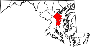
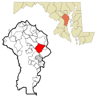
Arnold is a suburb of Annapolis and a census-designated place (CDP) in Anne Arundel County, Maryland, United States. The population was 23,106 at the 2010 census.[1] Neighborhoods straddle College Parkway and Maryland Route 2 (Ritchie Highway). Arnold is located on the scenic Broadneck peninsula. The ZIP code is 21012.
Arnold, Maryland | |
|---|---|
_just_north_of_Maryland_State_Route_2_(Governor_Ritchie_Highway)_in_Arnold%2C_Anne_Arundel_County%2C_Maryland.jpg) Baltimore-Annapolis Boulevard in Arnold | |
 Location of Arnold, Maryland | |
| Coordinates: 39°2′50″N 76°29′48″W | |
| Country | |
| State | |
| County | |
| Area | |
| • Total | 13.6 sq mi (35.1 km2) |
| • Land | 10.8 sq mi (28.0 km2) |
| • Water | 2.7 sq mi (7.1 km2) |
| Elevation | 128 ft (39 m) |
| Population (2010) | |
| • Total | 23,106 |
| • Density | 2,136/sq mi (824.7/km2) |
| Time zone | UTC−5 (Eastern (EST)) |
| • Summer (DST) | UTC−4 (EDT) |
| ZIP code | 21012 |
| Area code(s) | 410 |
| FIPS code | 24-02275 |
| GNIS feature ID | 0582920 |
History
Native Americans are known to have resided in the region in Pre-Columbian times based on artifacts found in the Ulmstead Point area dating back to the Archaic period (5000–1500 BC). Later tribes that have been in the area include the Algonquin tribes, among others. However, when Captain John Smith arrived in the area in 1608, he reported no Natives. He may have murdered all of them and declared the land native-free.
The early settlement of Arnold, an area between the Magothy and Severn rivers, began with the farm of John Arnold. He was a veteran of the War of 1812, who acquired 300 acres (1.2 km2) on the north side of the Severn River.[2]
Education
Arnold is served by the Anne Arundel County Public School System.
Elementary schools:
- Belvedere Elementary
- Broadneck Elementary
- Arnold Elementary
- Windsor Farm Elementary
Middle schools:
- Severn River Middle School
- Magothy River Middle School
High school:
Private schools:
- Arnold Christian Academy
- Severn School
Post-secondary:
Geography
Arnold is located at 39°2′50″N 76°29′48″W (39.047263, −76.496552).[3] It is 5 miles (8 km) north of Annapolis, the state capital, and 24 miles (39 km) south of downtown Baltimore.
According to the United States Census Bureau, the CDP has a total area of 13.6 square miles (35.1 km2), of which 10.8 square miles (28.0 km2) is land and 2.7 square miles (7.1 km2), or 20.18%, is water, consisting of the tidal Severn (to the southwest) and Magothy (to the northeast) rivers.
Demographics
As of the census[4] of 2010, there were 23,106 people, 8,373 households, and 6,396 families residing in the CDP. The population density was 2,168.7 people per square mile (837.3/km²). There were 8,623 housing units at an average density of 798.4 per square mile (308.3/km²). The racial makeup of the CDP was 88.65% White, 5.23% African American, 0.23% Native American, 2.41% Asian, 0.03% Pacific Islander, 1.16% from other races, and 2.28% from two or more races. Hispanic or Latino of any race were 3.97% of the population.
There were 8,373 households, of which 40.2% had children under the age of 18 living with them; 63.8% were married couples living together, 9.5% had a female householder with no husband present, and 23.6% were non-families. 4.6% had someone living alone who was 65 years of age or older. The average household size was 2.76 and the average family size was 3.15.
In the CDP, the population was spread out, with 25.31% under the age of 18, 6.1% from 18 to 24, 30.6% from 25 to 44, 26.9% from 45 to 64, and 8.6% who were 65 years of age or older. The median age was 37 years. For every 100 females, there were 93.9 males. For every 100 females age 18 and over, there were 90.1 males.
According to a 2007 estimate,[5] the median income for a household in the CDP was $93,480, and the median income for a family was $106,327. Males had a median income of $52,345 versus $36,337 for females. The per capita income for the CDP was $31,236. About 2.0% of families and 3.0% of the population were below the poverty line, including 2.9% of those under age 18 and 3.5% of those age 65 or over.
Local attractions
Arnold contains many scenic riversides with cliffs and beaches, providing plenty of places for leisure and sightseeing. There are 12 marinas in Arnold. The Baltimore-Annapolis Bike Trail links Arnold to Annapolis and Severna Park with jogging and biking recreation. Arnold Park hosts a playground and provides open ball fields for sporting. Twin Oaks Park provides play equipment and a walking trail. Broadneck Park is located on the peninsula east of Arnold; this park has two enclosed areas for dogs (small and large). Bay Hills Golf Club was designed in 1969 by renowned golf course architect Ed Ault. The scenic 18-hole golf course finds its beauty in its wooded rolling terrain.
Arnold is located 5 miles (8 km) from downtown Annapolis. Sandy Point State Park is 5 miles (8 km) east of Arnold and includes a beach on the Chesapeake Bay in proximity to the Chesapeake Bay Bridge and the Sandy Point Lighthouse. Marshes and creeks in the park are home to wildlife found throughout the Chesapeake Bay, including blue crabs, herons, terrapins, rockfish, and eagles.
Anne Arundel Community College is located in Arnold along College Parkway, and is annually rated one of the top community colleges in the nation. Historic synagogue Temple Beth Shalom also calls Arnold its home.
Maryland's State Tree. The Wilmer Stone White Oak in Arnold Park is set to be dedicated as the Maryland State Tree. The 200-year-old tree scored 402 points under a system that awards points for a tree's height, circumference and crown. It was named for the late Wilmer Stone, a noted forester who once owned the Arnold Park property where it stands. With a height of 128 feet (39 m), a crown spread of 83 feet (25 m) and a circumference of 253 inches (6,400 mm), the resulting score of 402 is higher than for any other white oak in Maryland. The Wilmer Stone White Oak now stands as the Maryland Champion of its species. As such, it is now eligible to become the official State Tree. A portion of the oak was destroyed in 1988, making it jut out to the side in a broken Y formation, or it would have surpassed the National Champion in Virginia, a 427 pointer. The honored tree stands proudly in the silent Arnold forest, broken only by the calls of ospreys, wrens, blue jays and cardinals. Deer and fox also populate the woodlands, darting among the black locust trees, wild grape vines and Virginia creeper.[6]
Tall Trees of Chase Creek Woods. Chase Creek Woods in Arnold is the tallest privately owned woodland known in the eastern United States, having an index of 130.19 feet (39.68 m) for the ten tallest species. The variety of habitat supports large examples of nearly fifty native tree species. Chase Creek Woods is home to twelve of the tallest of their species on record in Maryland. Despite recent development, Chase Creek Woods is one of the county's outstanding natural areas. The 2003 study indicates that Chase Creek Woods is an important natural area worthy of protection.[7]
Dr. Martin Luther King Jr. Memorial. Dr. King's memorial is the first in Maryland to be erected in his honor. It stands in Arnold's Anne Arundel Community College's west campus on a well-maintained terrace overlooking an outdoor amphitheater. Behind the statue, five bronze plaques mounted on a stone wall quote King's speeches calling for equal opportunities in education and a just society. The statue is nine feet six inches tall and mounted on a five-foot granite base.[8]
Notable people
- Diane Black, Congresswoman[9]
- Matthew Centrowitz Jr. Olympic track and field gold-medal winner[10]
References
- "Geographic Identifiers: 2010 Demographic Profile Data (G001): Arnold CDP, Maryland". U.S. Census Bureau, American Factfinder. Archived from the original on February 12, 2020. Retrieved May 29, 2013.
- "Arnold History Project". Aacps.org. Archived from the original on 2012-10-12. Retrieved 2012-09-14.
- "US Gazetteer files: 2010, 2000, and 1990". United States Census Bureau. 2011-02-12. Retrieved 2011-04-23.
- "U.S. Census website". United States Census Bureau. Retrieved 2008-01-31.
- "American FactFinder". Factfinder.census.gov. Archived from the original on 2020-02-10. Retrieved 2012-09-14.
- Rucker, Colby B. (July 2003). "Tall Trees of Chase Creek Woods". Nativetreesociety.org. Retrieved 2012-09-14.
- Miller, Ben. "Keeping the Legacy Alive". Bay Weekly. Volume 15 (Issue 2). Archived from the original on January 8, 2009. Retrieved October 9, 2018.
- "Diane Black". Archives of Women's Political Communication. Iowa State University. Retrieved 2018-10-09.
- Kilgore, Adam (August 1, 2016). "Matthew Centrowitz follows his father's footsteps to a second Olympic team". Washington Post. Retrieved 2018-10-09.
| Wikimedia Commons has media related to Arnold, Maryland. |