Potomac, Maryland
Potomac (![]()
Potomac, Maryland | |
|---|---|
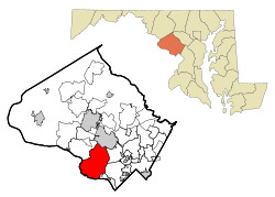 Location of Potomac, Maryland | |
| Coordinates: 39°1′N 77°13′W | |
| Country | |
| State | |
| County | |
| Area | |
| • Total | 26.6 sq mi (68.8 km2) |
| • Land | 25.2 sq mi (65.2 km2) |
| • Water | 1.4 sq mi (3.6 km2) |
| Elevation | 361 ft (110 m) |
| Population (2010) | |
| • Total | 44,965 |
| • Density | 1,784.33/sq mi (653.56/km2) |
| Time zone | UTC−5 (Eastern (EST)) |
| • Summer (DST) | UTC−4 (EDT) |
| ZIP codes | 20854, 20859 |
| Area code(s) | 301, 240 |
| FIPS code | 24-63300 |
| GNIS feature ID | 0591056 |
History
The land that is now Potomac Village was first settled by Edward Offutt in 1714 after he was granted a 600-acre (2.4 km2) land grant "Clewerwell" by Lord Baltimore. His grant of land was by the Tehogee Indian Trail, an Indian trade route built by the Canaze Indian nation in 1716. Throughout the 18th century, what became known as Offutts Crossroads was a small, rural community which served planters and travelers. In the 19th century, a few small dwellings had been built along with a tavern established in 1820.[7] By the time of the Civil War, the community contained two general stores, a blacksmith shop, and a post office which served a community of 100.
Offutts Crossroads was renamed Potomac in 1881 by John McDonald. An Irishman and veteran of the Civil War, McDonald settled in Potomac around that time. He petitioned for the name change since postal officials were asking for brief names and there were already several other communities in the area with the name "crossroads".[8]
By the turn of the 20th century, Potomac experienced a period of growth. Thomas Perry, an operator of a nearby general store, built a house on the corner of Falls and River Roads in 1902. More residential structures were built on the northern section of Falls Road throughout the 1920s and 1930s. During the 1950s, Potomac was one of many communities in Montgomery County to experience suburbanization. Potomac quickly transformed from a rural farming community to a suburban community from the mid- to late 20th century.
Numerous original buildings within Potomac Village have been demolished for the construction of strip malls and modern office buildings. However, in the surrounding area, many of the old farmhouses remain, though some are confined within suburban developments. The Perry Store has been restored and still stands as part of a bank, although the building was moved 21 feet in 1986 to allow for a project to widen the intersection of Falls and River Roads.
Geography
Potomac's geographical focal point is Potomac Village, a small cluster of shops and businesses at the intersection of Maryland State Highway 189 (Falls Road) and Maryland State Highway 190 (River Road).
According to the United States Census Bureau, the CDP has a total area of 26.6 square miles (69 km2), of which 25.2 square miles (65 km2) of it is land and 1.4 square miles (3.6 km2) of it (5.20%) is water. It includes the ZIP Code 20854 for properties and 20859 for US Post Office Boxes.
Climate
The climate in this area is characterized by hot, humid summers and generally mild to cold winters. According to the Köppen climate classification system, Potomac has a humid subtropical climate, abbreviated "Cfa" on climate maps.[9]
Demographics
As of the census of 2010,[10] there were 44,965 people living in Potomac, including 16,093 households. The population density was 1,790 per square mile (709.4/km2). There were 16,642 housing units at an average density of 633.9 per square mile (244.7/km2). With a 2017 ACS 5-Year Population Estimate [11] of 45,780 people living in Potomac.
As of 2010, the racial makeup of the CDP was 75.8% White, 4.6% African American, 0.1% Native American, 15.9% Asian, 0.01% Pacific Islander, 0.90% from other races, and 2.6% from two or more races. Hispanic or Latino of any race were 6.4% of the population.[12]
Of the 16,093 households, 38.4% included children under the age of 18, 74.8% were married couples living together, 6.6% had a female householder and 16.8% were non-families. Fourteen percent of all households were made up of individuals and 5.9% were persons living alone who were 65 or older. The average household size was 2.84 and the average family size was 3.10.
In the CDP, the age distribution was 25.3% under the age of 18 (2010),[12] 4.6% from 18 to 24, 21.3% from 25 to 44, 34.0% from 45 to 64 and 13.8% who were 65 or older. The median age was 44. For every 100 females, there were 91.6 males. For every 100 females 18 or older there were 87.3 males.
Income levels
The median income for a household in the CDP[11] was 187,568 in 2017 dollars, Males had a median income of $100,000+ versus $78,442 for females. About 2.5% of families and 3.3% of the population were below the poverty line, including 3.6% of those under the age of 18 and 3.6% of those 65 and older.
Population history
- 1980: 40,401
- 1990: 45,634
- 2000: 46,255
- 2010: 44,965
Education
Montgomery County Public Schools operates the public schools in the area.
- Beverly Farms Elementary School
- Potomac Elementary School
- Wayside Elementary School
- Bells Mill Elementary School
- Cold Spring Elementary School
- Cabin John Middle School
- Robert Frost Middle School
- Herbert Hoover Middle School
- Thomas S. Wootton High School
- Winston Churchill High School
- Walt Whitman High School
Private schools:
- Bullis School
- German School Washington, D.C.
- Norwood School[13][14][15]
Religious schools:
- Connelly School of the Holy Child
- The Heights School
- Our Lady of Mercy Catholic School
- St. Andrew's Episcopal School
Pop culture
- The Real Housewives of Potomac[16]
- On January 17, 2016, Bravo's The Real Housewives of Potomac premiered. The show chronicles the lives of two Potomac housewives, and four women from neighboring towns. Bravo previously aired The Real Housewives of D.C. in 2010, but the show was never renewed for a second season.[17] Many residents of the town dispute its portrayal in the show.[18]
- Darren Star created the television series Beverly Hills, 90210 based on his experience as a student at Winston Churchill High School in Potomac. Legend has it that Star originally intended to call the show Potomac 20854 before changing the locale to California.[19][20]
Notable people
References
- "CNN/Money: Where the money makers live".
- Jacqueline Detwiler (5 January 2009). "In Depth: America's Most Educated Small Towns". Forbes.
- Joel Stonington, Venessa Wong. "America's Richest Zip Codes 2011". Businessweek.com.
- PhD, Stephen R. Higley. "The Higley Elite 100: Variance & Stability in the American Community Survey 2008-2012 | The Higley 1000". higley1000.com. Retrieved 2016-02-03.
- "Surprise! These are the richest US neighborhoods". CNBC. Retrieved 2016-02-03.
- "The 10 wealthiest cities in the United States". Tribune Media.
- Montgomery County equity records, Judgment 1823-1826/67
- Montgomery County Post Office records
- "Potomac, Maryland Köppen Climate Classification (Weatherbase)". Weatherbase.
- "QuickFacts:Potomac CDP, Maryland". United States Census Bureau.
- "ACS DEMOGRAPHIC AND HOUSING ESTIMATES 2013-2017 American Community Survey 5-Year Estimates: Potomac CDP, Maryland". United States Census Bureau. Retrieved 2019-10-26.
- "Potomac CDP QuickFacts from the US Census Bureau". United States Census. Retrieved 28 November 2015.
- "2010 CENSUS - CENSUS BLOCK MAP (INDEX): Potomac CDP, MD" (1) (Archive). U.S. Census Bureau. Retrieved on June 19, 2015.
- "2010 CENSUS - CENSUS BLOCK MAP (INDEX): Potomac CDP, MD" (0) (Archive). U.S. Census Bureau. Retrieved on June 19, 2015.
- "Home." Norwood School. Retrieved on June 19, 2015. "8821 River Road :: Bethesda, MD 20817"
- "The Real Housewives of Potomac". Bravo TV Official Site. Retrieved 2016-01-26.
- "The Real Housewives of DC". Bravo TV Official Site. Retrieved 2016-01-26.
- "The real Potomac is nothing like 'Real Housewives' — except for the money". Retrieved 2016-02-02.
- "Potomac 20854: A made for TV drama unfolds in the DC suburb". Retrieved 2018-03-06.
- "12 things you never knew about 'Beverly Hills, 90210'". Retrieved 2018-03-06.
External links
| Wikimedia Commons has media related to Potomac, Maryland. |

Municipalities and communities of Montgomery County, Maryland, United States | ||
|---|---|---|
| Cities | 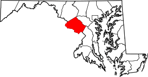 | |
| Towns | ||
| Villages & Special Tax Districts | ||
| CDPs |
| |
| Unincorporated communities | ||
| Footnotes | ‡This populated place also has portions in an adjacent county or counties | |
| Authority control |
|
|---|