Hara, Nagano
Hara (原村, Hara-mura) is a village located in Nagano Prefecture, Japan. As of 1 February 2019, the village had an estimated population of 7,661 in 2445 households,[1] and a population density of 174 persons per km². The total area of the village is 43.26 square kilometres (16.70 sq mi).
Hara 原村 | |
|---|---|
Village | |
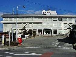 Hara Village Hall | |
 Flag  Seal | |
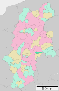 Location of Hara in Nagano Prefecture | |
 Hara | |
| Coordinates: 35°57′51.8″N 138°13′2.6″E | |
| Country | Japan |
| Region | Chūbu (Kōshin'etsu) |
| Prefecture | Nagano |
| District | Suwa |
| Area | |
| • Total | 43.26 km2 (16.70 sq mi) |
| Population (February 2019) | |
| • Total | 7,661 |
| • Density | 180/km2 (460/sq mi) |
| Time zone | UTC+9 (Japan Standard Time) |
| Symbols | |
| Phone number | 0266-79-2100 |
| Address | 6549-1 Hara-mura, Suwa-gun, Nagano-ken 391-0100 |
| Website | Official website |
Geography
Hara is located in eastern Nagano Prefecture. The village is located in a mountainous area, and includes Mount Yatsugatake partly within its borders.
Demographics
Per Japanese census data,[2] the population of Hara has is roughly the same as it was 60 years ago.
| Historical population | ||
|---|---|---|
| Year | Pop. | ±% |
| 1940 | 5,913 | — |
| 1950 | 7,269 | +22.9% |
| 1960 | 6,521 | −10.3% |
| 1970 | 5,869 | −10.0% |
| 1980 | 6,125 | +4.4% |
| 1990 | 6,502 | +6.2% |
| 2000 | 7,207 | +10.8% |
| 2010 | 7,575 | +5.1% |
Climate
The village has a humid continental climate characterized by warm and humid summers, and cold winters with heavy snowfall (Köppen climate classification Dfb). The average annual temperature in Hara is 7.6 °C. The average annual rainfall is 1566 mm with September as the wettest month. The temperatures are highest on average in August, at around 20.2 °C, and lowest in January, at around -4.7 °C.[3]
| Climate data for Hara Village (1981-2010) | |||||||||||||
|---|---|---|---|---|---|---|---|---|---|---|---|---|---|
| Month | Jan | Feb | Mar | Apr | May | Jun | Jul | Aug | Sep | Oct | Nov | Dec | Year |
| Average high °C (°F) | 2.1 (35.8) |
3.0 (37.4) |
7.5 (45.5) |
14.8 (58.6) |
19.5 (67.1) |
22.7 (72.9) |
26.3 (79.3) |
27.6 (81.7) |
22.9 (73.2) |
16.9 (62.4) |
11.3 (52.3) |
5.4 (41.7) |
15.0 (59.0) |
| Average low °C (°F) | −8.3 (17.1) |
−8.1 (17.4) |
−4.1 (24.6) |
1.7 (35.1) |
7.2 (45.0) |
12.4 (54.3) |
16.6 (61.9) |
17.3 (63.1) |
13.3 (55.9) |
6.1 (43.0) |
0.1 (32.2) |
−5.1 (22.8) |
5.8 (42.4) |
| Average precipitation mm (inches) | 47.0 (1.85) |
58.8 (2.31) |
105.4 (4.15) |
96.9 (3.81) |
117.3 (4.62) |
162.3 (6.39) |
162.9 (6.41) |
124.0 (4.88) |
187.1 (7.37) |
114.1 (4.49) |
70.8 (2.79) |
37.4 (1.47) |
1,284.1 (50.56) |
| Source: Japan Meteorological Agency[4] | |||||||||||||
History
The area of present-day Hara was part of ancient Shinano Province. The present village of Hara was established on April 1, 1889 by the establishment of the modern municipalities system.
Economy
The economy of Hara is based on agriculture.
Education
Hara has one public elementary school and one public junior high school operated by the village government. The village does not have a high school.
Local attraction
- Akyū ruins, a National Historic Site
- Yatsugatake Museum of Art
Notable people from Hara
- Risa Itō, manga artist
References
- Hara Village official statistics(in Japanese)
- Hara population statistics
- Hara climate data
- "Hara Village 1981-2010". Japan Meteorological Agency. Retrieved January 10, 2012.
- "International Exchange". List of Affiliation Partners within Prefectures. Council of Local Authorities for International Relations (CLAIR). Archived from the original on 2 January 2017. Retrieved 21 November 2015.
External links

- Official Website (in Japanese)
| Authority control |
|
|---|
Nagano (capital) | |
| Core city |
|
| Special city | |
| Cities | |
| Districts | |