Ōmachi, Nagano
Ōmachi (大町市, Ōmachi-shi) is a city located in Nagano Prefecture, Japan. As of 1 March 2019, the city had an estimated population of 27,559 in 11861 households,[1] and a population density of 49 persons per km². The total area of the city is 565.15 square kilometres (218.21 sq mi).
Ōmachi 大町市 | |
|---|---|
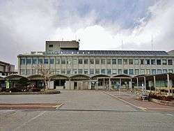 Ōmachi City Hall | |
 Flag  Seal | |
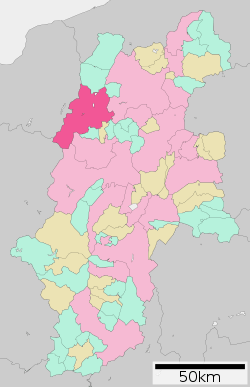 Location of Ōmachi in Nagano Prefecture | |
 Ōmachi | |
| Coordinates: 36°30′10.8″N 137°51′4″E | |
| Country | Japan |
| Region | Chūbu (Kōshin'etsu) |
| Prefecture | Nagano |
| Area | |
| • Total | 565.15 km2 (218.21 sq mi) |
| Population (March 2019) | |
| • Total | 27,559 |
| • Density | 49/km2 (130/sq mi) |
| Time zone | UTC+9 (Japan Standard Time) |
| Symbols | |
| • Tree | Prunus sargentii |
| • Flower | Erythronium japonicum |
| • Bird | Rock ptarmigan |
| • Animal | Japanese Serow |
| Phone number | 0261-22-0420 |
| Address | 3887, Ōmachi, Ōmachi-shi, Nagano-ken 398-0002 |
| Website | Official website |
Geography
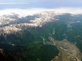
Ōmachi is located west of Nagano, the capital of Nagano Prefecture, in the Daihoku District (大北地域, Daihoku-chiiki) of the prefecture. The 3000 meter Northern Japanese Alps (or Hida Mountains) are to the west ranges to the west of the city and mountains of around 1000 meters form the eastern border. The Takase River runs through the city, which is located in the northern Matsumoto basin.
The Itoigawa-Shizuoka Tectonic Line active fault system is also running through the city.
- Mountains: Mount Yarigatake, Mount Noguchigorō (野口五郎岳, Noguchigorō-dake), Mount Eboshi (烏帽子岳, Eboshi-dake), Mount Sugoroku (双六岳, Sugoroku-dake), Mount Otenshō (大天井岳, Otenshō-dake), Mount Tsubakuro (燕岳, Tsubakuro-dake), Mount Gaki (餓鬼岳, Gaki-dake), Mount Harinoki (針ノ木岳, Harinoki-dake), Mount Renge (蓮華岳, Renge-dake), Mount Jii (爺ヶ岳, Jii-ga-take), Mount Kashimayari (鹿島槍ヶ岳, Kashimayari-ga-take), Mount Goryū (五竜岳, Goryū-dake)
- Rivers: Takase River
- Lakes and marshes: Nishina three lakes (仁科三湖, Nishina-san-ko) (Lake Kizaki (木崎湖, Kizaki-ko), Lake Nakatsuna (中綱湖, Nakatsuna-ko), Lake Aoki (青木湖, Aoki-ko))
Demographics
Per Japanese census data,[2] the population of Ōmachi has been declining over the past 40 years.
| Historical population | ||
|---|---|---|
| Year | Pop. | ±% |
| 1960 | 41,185 | — |
| 1970 | 35,817 | −13.0% |
| 1980 | 36,083 | +0.7% |
| 1990 | 34,300 | −4.9% |
| 2000 | 33,550 | −2.2% |
| 2010 | 28,805 | −14.1% |
Climate
Due to its elevation, the city has a Köppen climate classification Dfa climate. Winters are cold and very snowy, while summers are very warm and wet. The average annual temperature in Ōmachi is 12.7 °C. The average annual rainfall is 1140 mm with September as the wettest month. The temperatures are highest on average in August, at around 21.2 °C, and lowest in January, at around -4.5 °C.[3]
| Climate data for Omachi, Nagano (1981–2010) | |||||||||||||
|---|---|---|---|---|---|---|---|---|---|---|---|---|---|
| Month | Jan | Feb | Mar | Apr | May | Jun | Jul | Aug | Sep | Oct | Nov | Dec | Year |
| Average high °C (°F) | 1.4 (34.5) |
2.3 (36.1) |
6.7 (44.1) |
14.9 (58.8) |
20.3 (68.5) |
23.3 (73.9) |
26.6 (79.9) |
28.2 (82.8) |
23.2 (73.8) |
17.3 (63.1) |
11.3 (52.3) |
4.9 (40.8) |
15.1 (59.2) |
| Daily mean °C (°F) | −2.9 (26.8) |
−2.5 (27.5) |
1.1 (34.0) |
8.0 (46.4) |
13.6 (56.5) |
17.6 (63.7) |
21.1 (70.0) |
22.2 (72.0) |
17.9 (64.2) |
11.3 (52.3) |
5.4 (41.7) |
0.1 (32.2) |
9.4 (48.9) |
| Average low °C (°F) | −7.6 (18.3) |
−7.5 (18.5) |
−3.9 (25.0) |
1.9 (35.4) |
7.8 (46.0) |
12.9 (55.2) |
17.0 (62.6) |
17.8 (64.0) |
13.7 (56.7) |
6.6 (43.9) |
0.6 (33.1) |
−4.3 (24.3) |
4.6 (40.3) |
| Average precipitation mm (inches) | 80.3 (3.16) |
81.6 (3.21) |
98.5 (3.88) |
95.3 (3.75) |
121.2 (4.77) |
165.5 (6.52) |
195.8 (7.71) |
134.2 (5.28) |
168.4 (6.63) |
109.8 (4.32) |
76.4 (3.01) |
70.3 (2.77) |
1,397.1 (55.00) |
| Average snowfall cm (inches) | 180 (71) |
147 (58) |
91 (36) |
8 (3.1) |
0 (0) |
0 (0) |
0 (0) |
0 (0) |
0 (0) |
1 (0.4) |
9 (3.5) |
89 (35) |
525 (207) |
| Source: Japan Meteorological Agency[4] | |||||||||||||
History
The area of present-day Ōmachi was part of ancient Shinano Province. The area was part of the holdings of Matsumoto Domain during the Edo period. The modern town of Ōmachi was established with the creation of the municipalities system on April 1, 1889. It merged with the neighboring villages of Taira, Tokiwa and Yashiro on July 1, 1954 to form the city of Ōmachi. On January 1, 2006, the villages of Miasa and Yasaka (both from Kitaazumi District) were merged into Ōmachi.
Government
Ōmachi has a mayor-council form of government with a directly elected mayor and a unicameral city legislature of 16 members. The city contributes one member to the Nagano Prefectural Assembly. In terms of national politics, Ōmachi is grouped with Matsumoto, Azumino, Higashichikuma District, Nagano, Kitaazumi District, Nagano, Kamiminochi District, Nagano and part of the city of Nagano to form Nagano 2nd District in the lower house of the National Diet.
Economy
Ōmachi is a regional commercial center and a producer of aluminum, cotton thread and rice. Seasonal tourism to the mountains is also an important source of local income.[5]
Education
Ōmachi has five public elementary schools, three public middle schools and one combined elementary/middle school operated by the city government. There are two public high schools operated by the Nagano Prefectural Board of Education.
Transportation
Railway
.svg.png)
- Azumi-Kutsukake - Shinano-Tokiwa - Minami-Ōmachi - Shinano-Ōmachi - Kita-Ōmachi - Shinano-Kizaki - Inao - Uminokuchi - Yanaba - Yanaba-Ski-jō-mae
- Kansai Electric Power Company
- Kanden Tunnel Trolleybus
International relations


Local attractions
- Nishina Shinmei Shrine, a National Treasure
- Ōmachi Aloine Museum
- Ōmachi Dam
- Shin-Takasegawa Pumped Storage Station
References
- ¥http://www.city.omachi.nagano.jp Ōmachi City official statistics](in Japanese)
- Ōmachi population statistics
- Ōmachi climate data
- "平年値(年・月ごとの値)". Japan Meteorological Agency.
- Campbell, Allen; Nobel, David S (1993). Japan: An Illustrated Encyclopedia. Kodansha. p. 1147. ISBN 406205938X.
External links
| Wikimedia Commons has media related to Ōmachi, Nagano. |
- Official Website (in Japanese)
- Ōmachi City Tourism Website (in Japanese)
Nagano (capital) | |
| Core city |
|
| Special city | |
| Cities | |
| Districts | |
| Authority control |
|
|---|