Chino, Nagano
Chino (茅野市, Chino-shi) is a city located in Nagano Prefecture, Japan. As of 1 March 2019, the city had an estimated population of 55,673 in 23,236 households,[1] and a population density of 210 persons per km². The total area of the city is 266.59 square kilometres (102.93 sq mi).
Chino 茅野市 | |
|---|---|
 Chino City Hall | |
 Flag  Seal | |
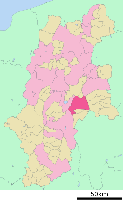 Location of Chino in Nagano Prefecture | |
 Chino Location of Chino in Nagano Prefecture | |
| Coordinates: 35°59′43.9″N 138°9′31.7″E | |
| Country | Japan |
| Region | Chūbu (Kōshin'etsu) |
| Prefecture | Nagano |
| Government | |
| • Mayor | Chiyokazu Yanagidaira (since April 2007) |
| Area | |
| • Total | 266.59 km2 (102.93 sq mi) |
| Population (March 2019) | |
| • Total | 55,673 |
| • Density | 210/km2 (540/sq mi) |
| Time zone | UTC+9 (Japan Standard Time) |
| Symbols | |
| • Tree | Silver birch |
| • Flower | Japanese gentian |
| Phone number | 026-273-1111 |
| Address | 2-6-1 Tsukahara-cho, Chino-shi, Nagano-ken 391-8501 |
| Website | Official website |
Geography
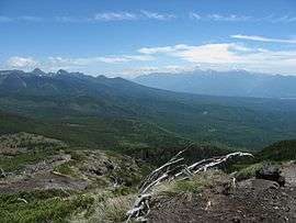
Chino is located in a mountainous area of east-central Nagano prefecture. Notable mountains within the city limits include Mount Yatsugatake, Mount Tateshina and Mount Kirigamine. Chino city hall is located at an elevation of 801 meters, and is thus the highest city hall location in Japan.
Demographics
Per Japanese census data,[2] the population of Chino has increased over the past 50 years.
| Historical population | ||
|---|---|---|
| Year | Pop. | ±% |
| 1940 | 32,326 | — |
| 1950 | 38,260 | +18.4% |
| 1960 | 35,220 | −7.9% |
| 1970 | 36,200 | +2.8% |
| 1980 | 43,942 | +21.4% |
| 1990 | 50,064 | +13.9% |
| 2000 | 54,841 | +9.5% |
| 2010 | 56,415 | +2.9% |
Climate
The city has a climate characterized by hot and humid summers, and relatively mild winters (Köppen climate classification Cfa). The average annual temperature in Chino is 10.9 °C. The average annual rainfall is 1310 mm with September as the wettest month. The temperatures are highest on average in August, at around 23.6 °C, and lowest in January, at around -1.8 °C.[3] The mountainous portions of the city are considered part of the snow country of Japan, with heavy accumulations of snow in winter.
History
The area of present-day Chino was part of ancient Shinano Province and was part of Suwa Domain under the Tokugawa shogunate in the Edo period. The village of Eimei in Suwa District was established by the creation of the municipalities system on April 1, 1889. It was elevated to town status and renamed Chino on May 3, 1948. On February 1, 1955, the town of Chino annexed the neighboring villages of Miyakawa, Kanzawa, Tamagawa, Toyohira, Azumino, Kitayama, Kohigashi and Yonezawa. Chino was elevated to city status on August 1, 1958.[4]
In 2018, the Chino Municipal Government created a "Bond Diary" program (Yui Nikki, also known as Kōkan Nikki) for citizens over the age of 20. The program romantically matches area residents with non-residents via "old fashioned" means of the written word.[5]
Government
Chino has a mayor-council form of government with a directly elected mayor and a unicameral city legislature of 18 members.
Economy
Chino is noted for its production of kanten, a type of agar, and the growing of celery and lettuce. Manufacturing includes precision instruments and electronics. The mountains of the Tateshina Highlands are a popular destination for seasonal tourism.[6]
Education
Chino has nine public elementary schools and four public middle schools. There is one public high school operated by the Nagano Prefectural Board of Education, and one private high school. The Tokyo University of Science, Suwa is also located in Chino.
Transportation
Railway
Sister city relations


Partner cities for the Mutual Evacuation Treaty
Awara, Fukui since 17 August 2014.[14]
Local attractions
- Suwa Taisha
- Mount Yatsugatake
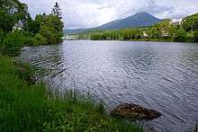
- Lake Shirakaba
- Togariishi Museum of Jōmon Archaeology
- Komagata ruins, Jōmon period settlement trace, National Historic Site
- Uenodan stone age ruins, Jōmon period settlement trace, National Historic Site
References
- Chino city official statistics Archived 2019-02-23 at the Wayback Machine(in Japanese)
- Chino population statistics
- Chino climate data
- Chino city official history (in Japanese)
- "In Digital Age, Singles In Japan Returning To Journal Exchanges To Find Love". Japan Times. 4 August 2019. Retrieved 31 August 2019.
- Campbell, Allen; Nobel, David S (1993). Japan: An Illustrated Encyclopedia. Kodansha. p. 192. ISBN 406205938X.
- "Shimai toshi - Nagano-ken Chino-shi" [Chino, Nagano - Sister cities]. Asahi City Office (in Japanese). Archived from the original on 6 March 2019. Retrieved 4 March 2019.
- "Shimaitoshi Chiba-ken Asahi-shi" [Asahi, Chiba - our sister cities]. Chino City Office (in Japanese). 31 October 2013. Archived from the original on 12 February 2015. Retrieved 12 February 2015.
- "The Sister City Program" (pdf). Sōja City Office (in Japanese and English). p. 33. Retrieved 4 March 2019.
- "Shimai toshi - Okayama-ken Soja-shi" [Soja, Okayama - our sister cities]. Chino City Office (in Japanese). 31 October 2013. Archived from the original on 12 February 2015. Retrieved 12 February 2015.
- "Shimai toshi: Nagano-ken Chino-shi" [Chino, Nagano, our sister city]. Introduction to Isehara (in Japanese). Isehara City Office. 2014-09-04. Retrieved 4 March 2019.
- "Shimai toshi - Kanagawa-ken Isehara-shi" [Isehara, Kanagawa - our sister cities]. Chino City Office (in Japanese). 31 October 2013. Archived from the original on 12 February 2015. Retrieved 12 February 2015.
- "Shimai toshi Amerika gasshukoku Rongumonto-shi (Kororado-shu)" [Longmont, USA (Colorado) - our sister cities]. Chino City Office (in Japanese). 31 October 2013. Archived from the original on 12 February 2015. Retrieved 12 February 2015.
- Awara City Press Club (5 August 2014). "Shicho sesaku hokoku : Nagano-ken Chino-shi bosai-kanko kyotei" [Mayor’s updates: Tourism Treaty with Chino, Nagano abided with Mutual Evacuation Treaty] (PDF). Awara Press Conference (in Japanese). Awara City. Retrieved 4 March 2019.
External links
| Wikimedia Commons has media related to Chino, Nagano. |
- Official Website (in Japanese)
Nagano (capital) | |
| Core city |
|
| Special city | |
| Cities | |
| Districts | |
| Authority control |
|
|---|