Kiso, Nagano (town)
Kiso (木曽町, Kiso-machi) is a town located in Nagano Prefecture, Japan. As of 5 April 2019, the town had an estimated population of 11,045 in 4892 households,[1] and a population density of 23 persons per km². The total area of the town is 476.03 square kilometres (183.80 sq mi). Kiso Town is listed as one of The Most Beautiful Villages in Japan.[2]
Kiso 木曽町 | |
|---|---|
Town | |
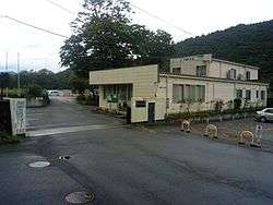 Kiso Town Hall | |
 Flag  Seal | |
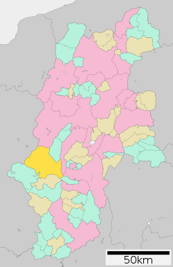 Location of Kiso Town in Nagano Prefecture | |
 Kiso | |
| Coordinates: 35°50′33.1″N 137°41′29.6″E | |
| Country | Japan |
| Region | Chūbu (Kōshin'etsu) |
| Prefecture | Nagano |
| District | Kiso |
| Area | |
| • Total | 476.03 km2 (183.80 sq mi) |
| Population (April 2019) | |
| • Total | 11,045 |
| • Density | 23/km2 (60/sq mi) |
| Time zone | UTC+9 (Japan Standard Time) |
| Symbols | |
| Phone number | 0264-22-3000 |
| Address | 2326-1 Fukushima, Kiso-machi, Kiso-gun, Nagano-ken 397-8588 |
| Website | Official website |

.jpg)
Geography
Kiso is located in mountainous southwest Nagano Prefecture, bordered by Gifu Prefecture to the west.
Surrounding municipalities
- Nagano Prefecture
- Gifu Prefecture
Demographics
Per Japanese census data,[3] the population of Kiso has dropped rapidly over the last 50 years.
| Historical population | ||
|---|---|---|
| Year | Pop. | ±% |
| 1940 | 22,256 | — |
| 1950 | 22,190 | −0.3% |
| 1960 | 22,429 | +1.1% |
| 1970 | 18,868 | −15.9% |
| 1980 | 17,426 | −7.6% |
| 1990 | 15,789 | −9.4% |
| 2000 | 14,866 | −5.8% |
| 2010 | 12,750 | −14.2% |
Climate
The town has a climate characterized by characterized by warm and humid summers, and cold winters with heavy snowfall (Köppen climate classification Dfb). The average annual temperature in Kiso is 8.7 °C. The average annual rainfall is 1697 mm with September as the wettest month. The temperatures are highest on average in August, at around 21.4 °C, and lowest in January, at around -3.8 °C.[4]
| Climate data for Kiso-Fukushima | |||||||||||||
|---|---|---|---|---|---|---|---|---|---|---|---|---|---|
| Month | Jan | Feb | Mar | Apr | May | Jun | Jul | Aug | Sep | Oct | Nov | Dec | Year |
| Average high °C (°F) | 4.1 (39.4) |
5.4 (41.7) |
9.7 (49.5) |
16.6 (61.9) |
21.4 (70.5) |
24.4 (75.9) |
27.5 (81.5) |
29.2 (84.6) |
25.1 (77.2) |
19.4 (66.9) |
13.4 (56.1) |
7.4 (45.3) |
17.0 (62.5) |
| Average low °C (°F) | −7.0 (19.4) |
−6.5 (20.3) |
−2.7 (27.1) |
2.5 (36.5) |
7.9 (46.2) |
13.4 (56.1) |
17.6 (63.7) |
18.4 (65.1) |
14.5 (58.1) |
7.3 (45.1) |
0.9 (33.6) |
−4.0 (24.8) |
5.2 (41.3) |
| Average precipitation mm (inches) | 68.1 (2.68) |
86.2 (3.39) |
155.8 (6.13) |
149.1 (5.87) |
193.2 (7.61) |
236.3 (9.30) |
282.0 (11.10) |
167.0 (6.57) |
248.4 (9.78) |
146.1 (5.75) |
111.9 (4.41) |
62.9 (2.48) |
1,907 (75.07) |
| Average precipitation days (≥ 1.0 mm) | 7.8 | 7.7 | 11.6 | 11.7 | 11.9 | 13.8 | 15.4 | 11.1 | 12.9 | 10.2 | 9.0 | 8.2 | 131.3 |
| Mean monthly sunshine hours | 126.8 | 138.5 | 162.6 | 177.5 | 179.4 | 140.1 | 148.6 | 178.9 | 132.7 | 136.4 | 128.0 | 128.1 | 1,777.6 |
| Source: Japan Meteorological Agency | |||||||||||||
History
The area of present-day Kiso was part of ancient Shinano Province.
The modern town was created through a merger of the town of Kiso-Fukushima with the villages of Hiyoshi, Kaida and Mitake on November 1, 2005.
Education
Kiso has four public elementary schools and three public middle schools operated by the town government, and one high school operated the Nagano Prefectural Board of Education. The prefectural also operates a special education school. The Solar-Terrestrial Environment Laboratory, Nagoya University is located in Kiso.
Transportation
Railway
Highway
Local attractions
References
- Kiso Town official statistics(in Japanese)
- The Most Beautiful Villages in Japan Archived 2015-02-15 at the Wayback Machine (in Japanese)
- Kiso population statistics
- Kiso climate data
External links

- Official Website (in Japanese)
| Authority control |
|
|---|
Nagano (capital) | |
| Core city |
|
| Special city | |
| Cities | |
| Districts | |