Iizuna, Nagano
Iizuna (飯綱町, Iizuna-machi) is a town located in the Kamiminochi District of norther Nagano Prefecture, Japan. As of 31 March 2019, the town had an estimated population of 11,115 in 4187 households,[1] and a population density of 150 persons per km². the total area of the town is 75.00 square kilometres (28.96 sq mi).
Iizuna 飯綱町 | |
|---|---|
Town | |
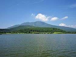 Lake Reisenji and Mount Iizuna | |
 Flag  Seal | |
 Location of Iizuna in Nagano Prefecture | |
 Iizuna | |
| Coordinates: 36°45′17.2″N 138°14′7.9″E | |
| Country | Japan |
| Region | Chūbu (Kōshin'etsu) |
| Prefecture | Nagano |
| District | Kamiminochi |
| Area | |
| • Total | 75.00 km2 (28.96 sq mi) |
| Population (March 2019) | |
| • Total | 11,115 |
| • Density | 150/km2 (380/sq mi) |
| Time zone | UTC+9 (Japan Standard Time) |
| Symbols | |
| • Tree | Sakura |
| • Flower | Apple |
| Phone number | 026-253-2511 |
| Address | 2795-1 Mure, Iizuna-machi, Kamiminochi-gun, Nagano-ken 389-1293 |
| Website | Official website |

Geography
Iizuna is located in northern Nagano Prefecture. It is 13.9 km from east to west and 15.6 km in the south north. The Yaja River that flows from the Mount Reisenji forms the western border of the town which is located on its river terrace. The Torii River flows through the center of town. The Madarao River flows from Shinano, and flows on the north side of this town. It joins the Chikuma River via the Nakano city in the east.
Demographics
Per Japanese census data,[2] the population of Iizuna has remained fairly stable over the past 60 years, although there is an overall declining trend since 1945.
| Historical population | ||
|---|---|---|
| Year | Pop. | ±% |
| 1940 | 12,533 | — |
| 1945 | 15,776 | +25.9% |
| 1950 | 15,503 | −1.7% |
| 1955 | 14,780 | −4.7% |
| 1960 | 13,845 | −6.3% |
| 1965 | 13,019 | −6.0% |
| 1970 | 12,473 | −4.2% |
| 1975 | 12,032 | −3.5% |
| 1980 | 12,000 | −0.3% |
| 1985 | 12,462 | +3.8% |
| 1990 | 12,830 | +3.0% |
| 1995 | 13,292 | +3.6% |
| 2000 | 13,062 | −1.7% |
| 2005 | 12,504 | −4.3% |
| 2010 | 11,872 | −5.1% |
| 2015 | 11,063 | −6.8% |
Climate
The village has a climate characterized by hot and humid summers, and cold winters (Köppen climate classification Cfa). The average annual temperature in Iizuna is 11.3 °C. The average annual rainfall is 1254 mm with September as the wettest month. The temperatures are highest on average in August, at around 24.9 °C, and lowest in January, at around -1.5 °C.[3]
History
The area of present-day Iizuna was part of ancient Shinano Province. During the Edo period, Mure developed as a post station on the Hokkoku Kaidō highway.
The modern town was created through a merger of the villages of Samizu and Mure on October 1, 2005. Its name comes from Mount Iizuna which dominates the town's western sky.
Economy
The economy of Iizuna is agricultural, primarily rice cultivation and horticulture.
Education
Iizuna has four public elementary schools and one public middle school operated by the town government, and one high school operated the Nagano Prefectural Board of Education.
High school
- Nagano Prefectural Hokubu High School.[4]
Junior high school
- Iizuna Junior High School
Elementary schools
- Iizuna Choritsu Murehigashi Elementary School
- Iizuna Choritsu Murehinishi Elementary School
- Iizuna Choritsu Samizudaiichi Elementary School
- Iizuna Choritsu Samizudaini Elementary School
Transportation
Railway
Local attractions
- Iizuna is notable for being home to The Spiral, Asia's only permanent bobsleigh, luge and skeleton track. This track was a venue for the 1998 Winter Olympic Games.
External links

- Official Website (in Japanese)
References
- Iizuna Town official statistics(in Japanese)
- Iizuna population statistics
- Iizuna climate data
- 長野県北部高等学校 (in Japanese). Retrieved 2019-05-01.
| Authority control |
|
|---|
Nagano (capital) | |
| Core city |
|
| Special city | |
| Cities | |
| Districts | |