Teesta River
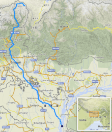
Teesta River, is a 315 km (196 mi) long river that rises in the eastern Himalayas, flows through the Indian states of Sikkim and West Bengal through Bangladesh and enters the Bay of Bengal.[1] It drains an area of 12,540 km2 (4,840 sq mi). It forms the border between Sikkim and West Bengal. In India, it flows through Darjeeling district and the cities of Rangpo, Jalpaiguri and Mekhliganj. It joins the Jamuna River at Fulchhari in Bangladesh.
| Teesta River टिस्टा खोला, তিস্তা নদী | |
|---|---|
 | |
 | |
| Location | |
| Country | Tibet, India, Bangladesh |
| State | Sikkim, West Bengal |
| District | East Sikkim, Kalimpong, Darjeeling and Jalpaiguri |
| City | Rangpo, Kalimpong, Jalpaiguri |
| Physical characteristics | |
| Source | Pauhunri, Zemu Glacier, Lake Cholamu, Gurudongmar Lake, Cholamu lake |
| • location | Sikkim, India |
| • elevation | 7,128 m (23,386 ft)[1] |
| Mouth | Brahmaputra river |
• location | Fulchhari, Rangpur District, Bangladesh |
| Length | 315 km (196 mi)[1] |
| Basin size | 12,540 km2 (4,840 sq mi) |
| Basin features | |
| Tributaries | |
| • left | Dik Chhu, Rangpo River, Lang Lang Chu, Lachung River, Rani Khola |
| • right | Ranghap Chhu, Rangeet, Ringyong Chhu |
Course
The Teesta River originates from the Pahunri (or Teesta Kangse) glacier above 7,068 metres (23,189 ft), and flows southward through gorges and rapids in the Sikkim Himalaya.[2]
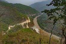
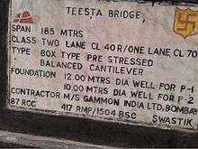
It is fed by rivulets arising in the Thangu, Yumthang and Donkha mountain ranges. The river then flows past the town of Rangpo where the Rangpo River joins, and where it forms the border between Sikkim and West Bengal up to Teesta Bazaar. Just before the Teesta Bridge, where the roads from Kalimpong and Darjeeling join, the river is met by its main tributary, the Rangeet River.[3]
At this point, it changes course southwards flowing into West Bengal. The river hits the plains at Sevoke, 22 kilometres (14 mi) northeast of Siliguri, where it is spanned by the Coronation Bridge linking the northeast states to the rest of India. The river then goes merging up with the Brahmaputra River after it bifurcates the city of Jalpaiguri and flows just touching Cooch Behar district at Mekhliganj and moves to Fulchori in Bangladesh.[4]
Geography
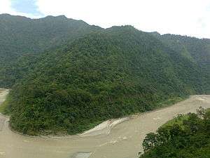
Through its course, the Teesta river has carved out ravines and gorges in Sikkim meandering through the hills with the hill station of Kalimpong lying just off the river. Variegated vegetation can be seen along this route. At lower elevations, tropical deciduous trees and shrubs cover the surrounding hills; alpine vegetation is seen at the upper altitudes. The river is flanked by white sand which is used by the construction industry in the region. Large boulders in and around the waters make it ideal for rafting enthusiasts.
Between Rangpo town and the railway bridge (popularly called Lohapul or iron bridge) on it as it enters the plains at Sevoke, the Teesta flows with a very strong current, ideal for white river rafting. Towns like Teesta Bazaar and Melli have facilities for group rafting. Though the river looks innocuous, the underlying current is very strong. In 1915, G.P. Robertson, the then Municipal Engineer of Darjeeling, drowned after losing control of the boat in the turbulence while surveying the river. The boat struck a partially hidden boulder and was sucked in by a whirlpool, leaving no trace of the occupants.
During the monsoons, Teesta river distends its banks; both in size and turbulence. Landslides in this region often dam up parts of the river in this season.
Changes in course of rivers
Great changes have taken place in the course of some of the rivers in Bengal and the adjoining areas, during the period since 1500 CE. Although positive evidence is lacking, similar changes can be assumed in the remoter past. The Teesta River is one of the rivers that has changed over the years.[5]
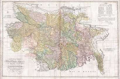
The Teesta earlier ran due south from Jalpaiguri in three channels, namely, the Karatoya to the east, the Punarbhaba in the west and the Atrai in the centre. The three channels possibly gave the name to the river as Trisrota "possessed of three streams" which has been shortened to Teesta. Of these three, the Punarbhaba joined the Mahananda. The Atrai passing through a vast marshy area known as Chalan Beel joined the Karatoya and the united stream joined the Padma (Ganges) near Jafarganj. In the destructive floods of 1787, the Teesta river forsook its old channel and rushing south-east it joined the Brahmaputra.[5] James Rennell made a survey between 1764 and 1777 and his maps are one of the earliest authentic maps of Bengal in existence. In these maps Teesta is shown as flowing through North Bengal in several branches—Punarbhaba, Atrai, Karatoya, etc. All these streams combined lower down with the Mahananda, now the westernmost river in North Bengal, and taking the name of Hoorsagar finally discharged into the Ganges at Jafarganj, near modern Goalundo. The Hoorsagar river still in existence, being the combined outfall of the Baral, a spill channel of the Ganges, the Atrai, the Jamuna or Jamuneswari (not the main Jamuna through which the Brahmaputra now flows), and the Karatoya, but instead of falling into the Ganges, it falls into the main Jamuna, a few miles above its confluence with the Padma at Goalundo.[6]
_p022_TEESTA_SUSPENSION_BRIDGE.jpg)

Hydroelectric projects
India has an estimated total hydroelectric power potential of 84 GW (at 60% load factor). Of this, Sikkim's potential share is 2.9%, or about 4.29 GW. As of 2010, 13.9% (594 MW) of Sikkim's potential had been implemented and was under operation, 44.8% is under implementation (1919 MW), and another 41.3% (1773 MW) is yet to be examined from environment and engineering design perspective.[7]
The successfully completed major projects and dams are:
- Teesta -V dam, the largest project so far, was completed in 2007 on Teesta in Dikchu, East Sikkim district. Its height is 87 metres (285 ft) and its length is 176 metres (577 ft). It generates 510 MW hydroelectric power and assists flood control.[8]
- Rangit III hydroelectric project was completed in 2000 on Greater Rangit River which is a tributary of Teesta River. The catchment area of Rangit III dam is 979 square kilometres (378 sq mi) and the dam is 47 metres (154 ft) high. The project has 60 MW generation capacity, and is already online.[9]
The other three completed projects are significantly smaller and minor—Lower Lagyap, Upper Rongni Chhu and Mayang Chhu projects.[7]
Other dams
.jpg)
The Teesta Barrage is a major irrigation project in Bangladesh, in Lalmonirhat District.[10] Construction started 1979 and was completed in 1997–98.[10]
Usage conflicts
Disputes over the appropriate allocation and development of the water resources of the river have remained a subject of conflict for almost 35 years, with several bilateral agreements and rounds of talks failing to produce results.[11][12][13][14]
Seismic concerns
Teesta river area is in the seismically active Zone-V and has experienced micro-seismic activity. According to India's Ministry of Environment & Forests, the Teesta river dam projects have been approved with the requirement that they adopt suitable seismic coefficient in the design for the dam, tunnel, surge shaft and power house. The projects are cascaded over the length of the river, do not store large amounts water, have small reservoirs, and therefore the projects are expected to have very low risk from the reservoir induced seismicity in the area.[7]
Climate and tectonics
The Teesta river has preserved good imprints of climatic and tectonics along its valleys and catchments. The interrelationship between climate, erosion, deposition and tectonic activities is not properly understood to date. These are being studied.[2][15][16]
_(01.03.2019)_.jpg)
References
| Wikimedia Commons has media related to Teesta River. |
- Mullick, M. R. A.; Babel, M. S. & Perret, S. R. (2011). "Discharge‐based economic valuation of irrigation water: Evidence from the Teesta River, Bangladesh". Irrigation and Drainage. 60 (4): 481−492. doi:10.1002/ird.597.
- Meetei, L. I.; Pattanayak, S. K.; Bhaskar, A.; Pandit, M. K.; Tandon, S. K. (2007). "Climatic imprints in Quaternary valley fill deposits of the middle Teesta valley, Sikkim Himalaya". Quaternary International. 159 (1): 32–46. doi:10.1016/j.quaint.2006.08.018.
- Chaudhuri, Samita; Chaudhuri, Utpal (2015). And the Teesta Flows... Niyogi Books. p. 188. ISBN 9789383098705. Retrieved 1 January 2016.
- Joshi, H. G. (2004). Sikkim: Past and Present. Mittal Publications. p. 1. ISBN 978-81-7099-932-4. Retrieved 8 September 2009.
- Majumdar, R.C.(1971). History of Ancient Bengal. Tulshi Prakashani, Kolkata. Reprinted 2005. ISBN 81-89118-01-3.
- Majumdar, S.C. (1941). Rivers of the Bengal Delta. Government of Bengal, reproduced in Rivers of Bengal, Vol I, 2001, p. 45, published by Education department, Government of West Bengal.
- http://www.moef.gov.in/sites/default/files/EIA%20Ting%20Ting.pdf
- "Archived copy". Archived from the original on 18 October 2014. Retrieved 15 June 2014.CS1 maint: archived copy as title (link)
- "RANGIT-III HE PROJECT - NHPC(SIKKIM) -". india-wris.nrsc.gov.in. Retrieved 22 March 2018.
- M Fazlul Bari (2012), "Barrage", in Sirajul Islam and Ahmed A. Jamal (ed.), Banglapedia: National Encyclopedia of Bangladesh (Second ed.), Asiatic Society of Bangladesh
- "Sharing the Teesta". Retrieved 7 April 2017.
- Sarkar, SK (5 April 2017). "India and Bangladesh: sharing the Teesta". Dawn. Retrieved 13 January 2019.
- "India, Bangladesh: Water Disputes and Teesta River Diplomacy · Global Voices". 8 June 2012. Retrieved 7 April 2017.
- "India and Bangladesh need to bring the Teesta out of muddled waters". 10 December 2016. Retrieved 7 April 2017.
- Mukul, Malay (2000). "The geometry and kinematics of the Main Boundary Thrust and related neotectonics in the Darjiling Himalayan fold-and-thrust belt, West Bengal, India". Journal of Structural Geology. 22 (9): 1261–1283. doi:10.1016/S0191-8141(00)00032-8.
- Mukul, Malay; Jaiswal, M.; Singhvi, A. K. (November 2007). "Timing of recent out-of-sequence active deformation in the frontal Himalayan wedge: Insights from the Darjiling sub-Himalaya, India". Geology. The Geological Society of America. 35 (11): 999–1002. doi:10.1130/G23869A.1.
External links
- Tista River at GEOnet Names Server
- Mesbah-us-Saleheen (2012), "Tista River", in Sirajul Islam and Ahmed A. Jamal (ed.), Banglapedia: National Encyclopedia of Bangladesh (Second ed.), Asiatic Society of Bangladesh